Unit 1.1. Water Cycle, Groundwater And Surface Water
Instructor: Mr. Kartik Omanakuttan
In this Unit 1.1, we begin with the physical foundation of water science: the movement, storage, and transformation of water through the hydrological cycle. The purpose of the unit is not simply to name processes such as evaporation, runoff, and recharge, but to understand how they connect atmosphere, land, rivers, wetlands, soils, and aquifers into one working system.
This unit is intentionally more theoretical than the later governance-oriented units. However, theory here is practical theory. A hydrologist estimating flood risk, an administrator reviewing a watershed plan, a practitioner designing a recharge structure, or a researcher interpreting water quality data all need the same first discipline: to ask where the water came from, where it is stored, how fast it moves, and what it carries with it.
The unit also introduces a habit of thinking that will continue through the rest of Module 1. We do not treat surface water, groundwater, water quality, and ecological condition as separate compartments. We begin with a connection. A river is connected to its catchment. A well is connected to an aquifer. A wetland is connected to seasonal flood pulses. A flood peak is connected to land cover. A dry-season flow is often connected to groundwater storage.
Lecturer: Dr. Sérgio António Neves Lousada
Lecture Topic: Hydraulic Planning in Insular Urban Territories: The Case of Madeira Island — São Vicente
Recorded Video: https://youtu.be/LR4Q2gKAnBE
PPT File
Zoom Chat
Reading Material
1.1.1 The Hydrological Cycle as a Connected System
What is the hydrological cycle and how does it work?
The hydrological cycle is the continuous circulation of water above, on, and below the Earth's surface. It has no single beginning and no final end. It can be entered analytically at precipitation, evaporation, transpiration, infiltration, runoff, groundwater flow, or storage, but each process only makes sense in relation to the others. The USGS water cycle diagrams (USGS, 2022) now explicitly show human water use alongside natural movement, which is useful because modern hydrology can no longer be taught as if people stand outside the cycle. The familiar classroom image of the water cycle can be misleading if it is read as a neat circle. Water does not move at one speed or along one fixed route. Atmospheric moisture may move across regions in days. Runoff may reach a stream within minutes or hours. Soil moisture may support vegetation for weeks (NASA, 2010). Groundwater may remain below ground for decades, centuries, or longer. The difference between rapid flux and slow storage is one of the central ideas of water science. A second key idea is partitioning. When rain falls on a catchment, it is divided among interception by vegetation, evaporation, transpiration, infiltration, recharge, overland flow, and channel flow. This partitioning depends on rainfall intensity, soil texture, slope, vegetation, antecedent moisture, geology, and land cover. The same 50 millimetres of rainfall can produce very different hydrological outcomes in a forested catchment, a compacted agricultural field, a dry rangeland, a glacier-fed basin, or a paved urban watershed.
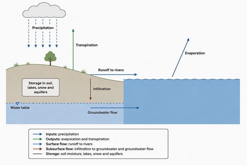
Figure 1.1.1: The hydrological cycle as movement and storage. Source: based on USGS (2022) and NOAA (n.d.) hydrologic cycle descriptions.
Storage is the part of the cycle that beginners often underestimate. Water is stored in snow and ice, soil moisture, wetlands, lakes, reservoirs, river channels, vegetation, unsaturated zones, and aquifers. Storage determines whether a catchment responds violently or gradually to rainfall. It also determines whether a region can carry water from wet periods into dry periods. A catchment with healthy soils, wetlands, and connected aquifers behaves differently from a catchment that has been drained, paved, or compacted. Residence time is equally important. It refers to how long water remains in a particular store before moving onward. Short residence times produce rapid response and are central to flood risk. Long residence times produce delayed responses and are central to groundwater recovery, pollutant persistence, and the time lag between an intervention and visible improvement. A fertilizer applied today may affect a stream quickly through runoff or slowly through groundwater pathways.
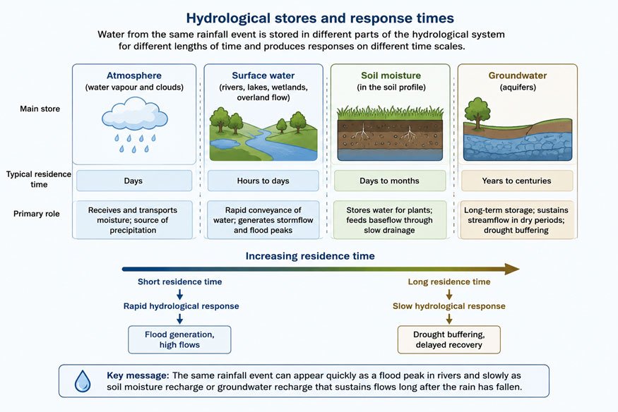
Figure 1.1.2: Residence time and the speed of hydrological response. Source: Kartik Omanakuttan
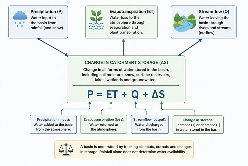
Figure 1.1.3: Basin water balance and storage change. Source: Kartik Omanakuttan
Read the Bare Fact
Water scarcity, floods, and contamination often begin as failures to understand the connection. A borewell is connected to an aquifer. A field drain is connected to a stream. A city road is connected to a flood peak. A wastewater outlet is connected to a downstream drinking-water intake. The water cycle is not background scenery. It is the operating system of every water decision (USGS, 2022).
Task and Instructions for Participants
All participants are advised to carefully review the following open-access materials before proceeding to the narration below. While watching or reading, do not memorize the diagram. Instead, identify where storage occurs, where water moves quickly, and where water moves slowly.
Essential watch
The relationship between groundwater and surface water, and the effect that one has on the other in terms of water quantity and quality
Additional watch
Overview of the water cycle and climate connections. Focus on how solar energy, temperature, and atmospheric circulation drive movement.
(Copyright: Source creators retain copyright. Links are to open-access educational content)
Narration - Water Moving Through a Landscape
Imagine a monsoon storm falling on a mixed catchment that includes forested hills, agricultural fields, a town, and a small river. The same storm produces several different kinds of water. On the forested slope, vegetation slows rainfall, litter absorbs it, and soil pores allow infiltration. Some of that water becomes soil moisture. Some moves laterally through shallow subsurface layers. Some percolates downward and becomes recharge. On a compacted field, especially after repeated tillage or heavy machinery movement, infiltration may be lower. Water moves faster across the surface, carrying sediment, fertilizer residues, and organic matter. In the town, roofs, roads, and drains convert rainfall into rapid runoff. The river, therefore, receives water not as a single smooth input, but as a combination of quick stormflow and slower baseflow. A hydrograph, which shows river discharge over time, is one of the simplest ways to see how a catchment works. A sharp peak after rainfall indicates rapid runoff and limited storage. A slower rise and fall suggest that soils, wetlands, floodplains, and aquifers are absorbing and releasing water more gradually. For flood management, water supply planning, and pollution control, the shape of the hydrograph matters as much as the total volume of rain.
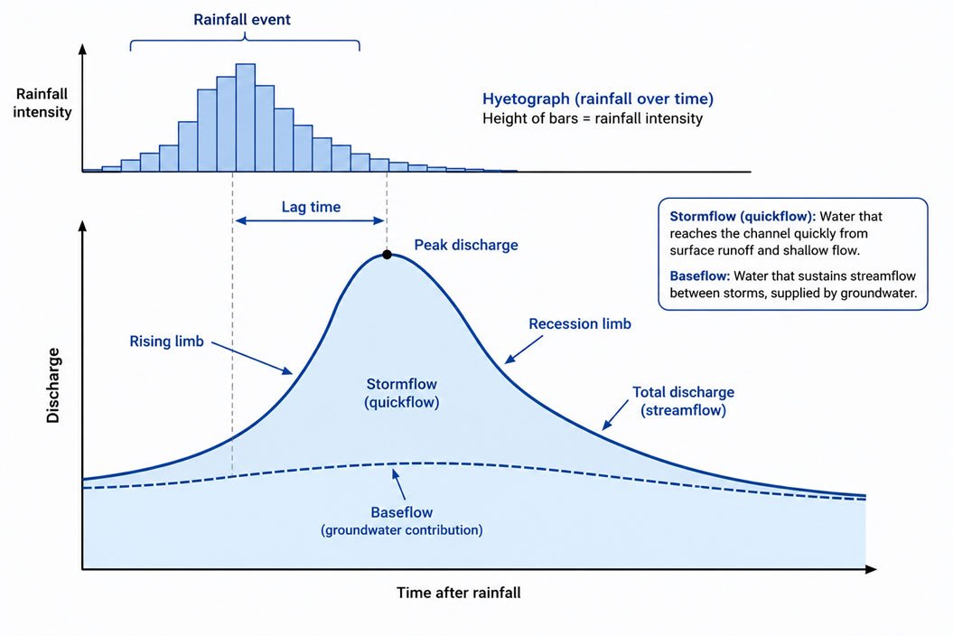
Figure 1.1.4: Hydrograph response showing stormflow and baseflow. Source: Kartik Omanakuttan
Reflective Questions (Mandatory for all students)
Please reflect on the following questions and post your thoughts in Forum W-001 under the tag "Reflective Questions 1.1". Try to connect the concepts to a place you know well.
- In a catchment familiar to you, where does rainwater move quickly, and where is it stored temporarily?
- In a catchment familiar to you, where does rainwater move quickly, and where is it stored temporarily?
- Can you identify a local river, lake, or wetland whose condition cannot be understood without considering upstream land and groundwater processes?
1.1.2 Surface Water Processes, Catchments and River Flow
Surface water includes rivers, streams, lakes, reservoirs, wetlands, and ponds. These water bodies are visible, but their behaviour is controlled by the catchments that feed them. A catchment, or watershed, is the area of land from which water drains to a common outlet. Every point on land belongs to a catchment, and catchment boundaries are therefore basic units for hydrological analysis. Catchments are not merely map units. They are working landscapes. Their slopes influence flow velocity, their soils influence infiltration, their vegetation influences evapotranspiration, and their geology influences groundwater movement. A catchment with deep, permeable soils will distribute rainfall differently from a catchment with shallow, rocky soils. A catchment with intact wetlands will attenuate flood peaks differently from a catchment with channelized drains.
River flow is built from several components: direct rainfall on the channel, overland flow, shallow subsurface flow, and groundwater discharge. NOAA describes total runoff as the combined contribution of these pathways, with streamflow commonly understood as a mixture of direct runoff and baseflow. This is why a river can continue to flow after weeks without rain: it is being supported by stored water, especially groundwater. Baseflow is particularly important for ecological and human use. During dry periods, baseflow sustains aquatic habitats, drinking-water intakes, irrigation withdrawals, and cultural uses of rivers. If groundwater levels decline, baseflow often declines too. This is one of the reasons why groundwater pumping can appear as a surface-water problem: the river does not need to be directly diverted for its dry-season flow to be reduced. Lakes and wetlands function differently from rivers because storage is more visible. A lake may buffer short-term inflows, allowing sediment to settle and nutrients to be processed. A wetland may slow water, reduce flood peaks, support biodiversity, and improve water quality. But storage also creates vulnerability. Pollutants can accumulate, nutrients can trigger eutrophication, and evaporation losses can be substantial in hot, dry climates. Surface-water science, therefore, requires attention to both movement and residence. A fast-flowing mountain stream, a floodplain wetland, and a deep reservoir cannot be interpreted with the same assumptions. Flowing water tends to transport materials downstream. Stored water tends to transform materials internally. The shift from a river to a reservoir behind a dam is therefore not only a change in quantity; it is a change in physical, chemical, and biological behaviour (NOAA, 2025).
Urban Runoff and Flood Peaks
Urbanization changes the water cycle by replacing permeable soil and vegetation with roofs, roads, parking areas, and storm drains. This does not create more rainfall; it changes the pathway. More water reaches channels quickly, flood peaks rise, and pollutants deposited on urban surfaces are washed into drains. In practical terms, a city is not simply located within a catchment. It actively rewires the catchment. This is why urban flood management cannot be reduced to larger drains alone. Larger drains may move water faster, but they can also increase downstream flood peaks. Sponge-city approaches, rain gardens, permeable pavements, restored urban wetlands, and protected floodplains are attempts to restore some of the storage and infiltration functions lost through urbanisation. Their success depends on design, maintenance, and the scale at which they are applied.
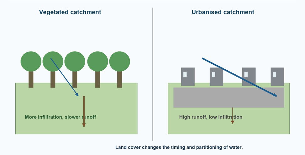
Figure 1.1.5: Land-cover change and runoff response. Source: Kartik Omanakuttan
1.1.3 Groundwater Occurrence, Recharge, and Storage
Groundwater is water stored below the land surface in pores, fractures, and other openings within soils and rocks. An aquifer is a geological formation that can store and transmit usable quantities of groundwater. Aquifers may be unconfined, where the water table forms the upper boundary, or confined, where water is stored beneath a low-permeability layer and may be under pressure. Recharge occurs when water infiltrates and percolates downward to replenish groundwater. Recharge is controlled by rainfall, soil texture, vegetation, slope, geology, land use, and the depth of the water table. It is not simply equal to rainfall. In many dry regions, a large part of rainfall returns to the atmosphere through evapotranspiration before it can recharge aquifers. The unsaturated zone, also called the vadose zone, lies between the land surface and the water table. It is crucial because water, nutrients, and contaminants move through it before reaching groundwater (Stonestrom, 2011). A thick unsaturated zone may delay contamination, but it may also store pollutants that continue to leach downward for years. A thin unsaturated zone can make groundwater more vulnerable to rapid contamination.
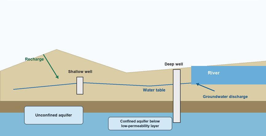
Figure 1.1.6: Aquifer types and basic groundwater movement. Source: Based on USGS (2022) groundwater and surface-water concepts.
Groundwater science requires attention to time. A shallow alluvial aquifer may respond to seasonal rainfall. A deep confined aquifer may contain older water that accumulated under different climatic conditions. Pumping such water can support agriculture or cities for a time, but if withdrawal exceeds recharge, the apparent supply is partly a withdrawal from storage. Hydraulic conductivity describes how easily water moves through a material. Gravel and coarse sand usually transmit water more readily than clay. Fractured rock may transmit water rapidly along cracks but slowly through the rock matrix. This is why two wells located close to each other may produce very different yields: the subsurface is rarely uniform. Groundwater storage can create a sense of security because aquifers are less visibly variable than rivers. However, this apparent stability can be deceptive. A falling water table may remain politically invisible until wells fail, pumping costs rise, or land subsidence becomes visible. The later groundwater decline is recognized, the harder it is to reverse. For practical field analysis, three questions are essential. First, where is the recharge occurring? Second, how fast does water move from recharge areas to wells, springs, or rivers? Third, what activities occur along that pathway? These questions link hydrology directly to water quality because groundwater does not merely store water; it stores the history of contact among water, rock, soil, and human activity.
1.1.4 Surface Water and Groundwater as One Resource
A major lesson from modern hydrology is that surface water and groundwater should not be treated as separate resources. USGS Circular 1139 (Winter et al., 1998) makes this point directly by describing groundwater and surface water as a single resource. Streams may gain water from aquifers, lose water to aquifers, or shift between gaining and losing conditions across seasons. In a gaining stream, groundwater discharges through the streambed and sustains flow. In a losing stream, stream water seeps downward and recharges the aquifer. In many real landscapes, the same river may gain water in one reach and lose water in another. Seasonal changes can also reverse the direction of exchange.
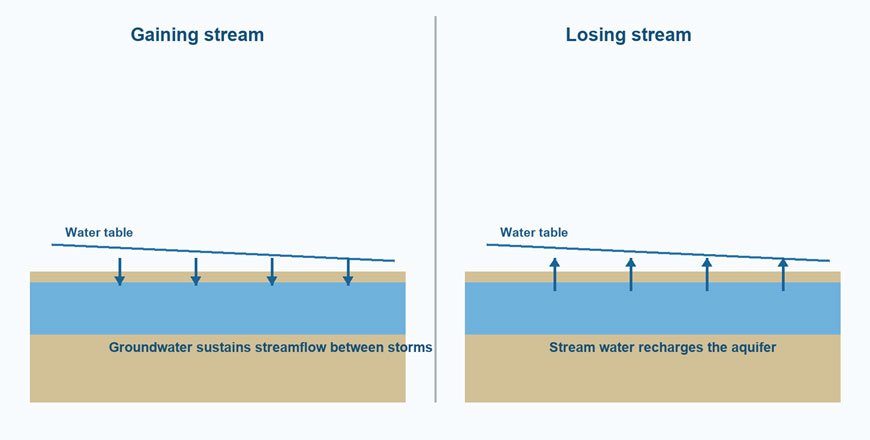
Figure 1.1.7: Gaining and losing streams as surface-water groundwater exchange. Source: based on USGS Circular 1139 (Winter et al., 1998).
This interaction has practical consequences. Pumping groundwater near a river can reduce river baseflow. Polluted river water can infiltrate into shallow aquifers. Recharge structures may improve local groundwater levels, but their effect depends on geology and hydraulic gradients. A river that appears to be a surface-water problem may therefore be partly a groundwater problem. Water quality also travels across the surface-water groundwater boundary. Nitrate from agricultural soils may move slowly through groundwater and emerge years later in a stream. Contaminated river water may infiltrate into shallow wells during pumping. Salinity from irrigation return flows may affect both shallow groundwater and drainage channels. The boundary is a zone of exchange, not a wall.
Wells Near Rivers
In alluvial plains, wells are often located near rivers because sediments are permeable and water levels are shallow. During wet periods, river water may recharge the aquifer. During dry periods, groundwater may sustain river flow. Heavy pumping can reverse gradients so that river water is drawn toward wells. This can be beneficial where river water is clean, but risky where river water carries pathogens, industrial effluent, or high nutrient loads. This example matters for drinking-water planning. A well that appears to draw groundwater may, under pumping conditions, draw a mixture of groundwater and riverbank filtrate. In some settings, bank filtration improves water quality by allowing sediments to filter particles and microbes. In other settings, it can transfer river contamination to water-supply wells. Hydrological context decides which interpretation is correct.
1.1.5 Hydrological Variability, Extremes and Climate Change
The water cycle is variable by nature. No catchment receives the same rainfall every year, and no river has a single normal flow. What climate change does is alter the probability and intensity of events. NASA and WMO both emphasise that a warmer atmosphere changes evaporation, atmospheric water vapour, and precipitation patterns, while WMO's (2024) assessment reported strong departures from normal conditions in rivers, reservoirs, lakes, groundwater, and glaciers. For water science, this means that averages are necessary but insufficient. A mean annual rainfall value can hide long dry spells, short intense storms, and seasonal shifts. A reservoir designed for historical flow may face new patterns of inflow. A recharge plan based on annual rainfall may fail if rainfall increasingly arrives in intense events that run off before infiltrating.
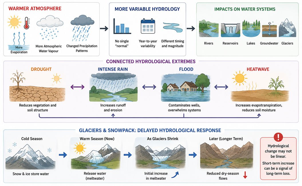
Fig 1.1.8: Climate change and hydrological extremes. Atmospheric warming intensifies the water cycle, producing greater variability in precipitation, more frequent droughts and floods, and altered cryospheric water storage, resulting in widespread impacts on freshwater systems. Source: Conceptually adapted from IPCC AR6 assessments of water-cycle (IPCC, 2021; IPCC, 2022).
Hydrological extremes are also connected. Drought can reduce vegetation cover and soil structure, increasing runoff when intense rain eventually arrives. Floods can contaminate shallow wells and overwhelm wastewater systems. Heatwaves can increase evapotranspiration and reduce soil moisture even without a major decline in rainfall. Therefore, drought, flood, heat and water quality should not be analysed as entirely separate problems. Glaciers and seasonal snowpacks illustrate a delayed hydrological response. They store water in cold seasons and release it during warmer periods. As glaciers shrink, some basins may initially experience increased meltwater, followed later by reduced dry-season flows. This is an important example of why hydrological change may not be linear: a short-term increase in water can be a signal of long-term loss.
1.1.6 Applied Hydrological Reading of a Catchment
To apply Unit 1.1, participants should learn to read a catchment before judging a water problem. The first question is always about boundaries: what land area contributes water, sediment, nutrients, or contaminants to the point of concern? The second question is about pathways: does water reach the point mainly through overland flow, drains, shallow subsurface flow, groundwater discharge, or direct channel flow? The third question concerns storage. Where is water held in the catchment before it moves onward? Storage may occur in wetlands, ponds, reservoirs, soils, snow, floodplains, aquifers, and even vegetation. Loss of storage usually produces a faster hydrological response. Restoration of storage can reduce flood peaks, support dry-season flows, and improve some water quality conditions. The fourth question concerns time. Is the problem immediate, seasonal, or delayed? Flood peaks are often immediate. Dry-season scarcity is seasonal. Groundwater contamination and aquifer depletion may be delayed. A good water diagnosis should identify the relevant time scale before proposing a solution.
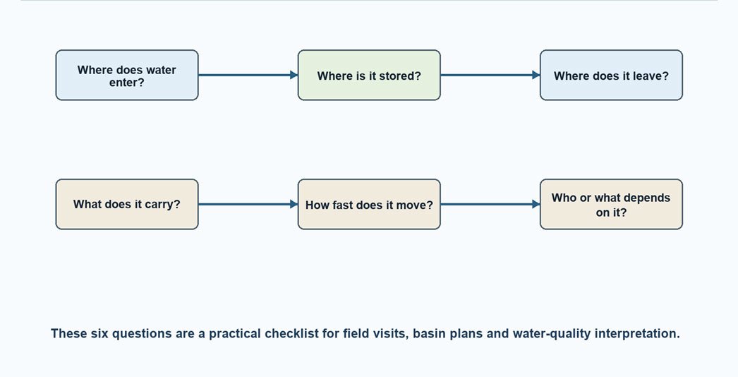
Figure 1.1.9: Reading a catchment through hydrological questions. Source: Kartik Omanakuttan
Field Exercise for Students
Choose one water body, well, wetland, or drainage channel in your region. Prepare a one-page catchment note using the six diagnostic questions in Figure 1.1.8. Do not begin with a solution. Begin with the movement of water.
Hydrological Measurements and Evidence
Hydrological interpretation requires evidence. Rainfall gauges, stream gauges, groundwater observation wells, soil-moisture measurements, evaporation pans, remote sensing and field observation all provide partial views of the water cycle. None of them is sufficient alone. A rainfall record without streamflow tells us little about runoff response. A stream gauge without groundwater levels may miss the contribution of baseflow. A groundwater hydrograph without pumping data may be misread as climate variability.
The most basic measurement is precipitation, but even rainfall is not simple. A single gauge can miss spatial variation, especially in mountain regions and convective storms. Radar and satellite estimates improve spatial coverage but require calibration. For local planning, participants should ask whether rainfall data represent the actual catchment or merely the nearest station. Streamflow measurement converts water level into discharge through a rating curve. This is a powerful tool, but rating curves can change when channels erode, sediment deposits, vegetation grows, or floods modify the cross-section. A measured river level is therefore not automatically a reliable flow estimate unless the rating relationship is maintained. Groundwater monitoring requires repeated water-level measurements in wells whose construction and aquifer setting are known. A single well level is only a snapshot. A time series reveals recharge pulses, seasonal decline, pumping stress, and long-term trends. In many regions, the absence of groundwater monitoring is itself a major scientific limitation. Uncertainty should be made visible rather than hidden. Hydrological data are affected by instrument error, spatial variation, missing records, and interpretation assumptions. A professional water assessment is not weakened by acknowledging uncertainty. It is strengthened when uncertainty is clearly described and when decisions are tested against a range of plausible conditions. For this reason, the water balance should be treated as both an equation and an investigative discipline. If estimated precipitation, evapotranspiration, runoff, and storage change do not fit together, the mismatch is not merely a calculation problem. It is an invitation to re-examine assumptions, data quality, and unmeasured pathways.
Common Misreadings of the Water Cycle
A common mistake is to treat rainfall as water availability. Rainfall is only an input. Availability depends on how much infiltrates, how much runs off, how much evaporates, how much is stored, and whether the water remains usable. This mistake is especially common in public debate after heavy rainfall, when visible flooding is wrongly interpreted as proof that scarcity has disappeared. A second mistake is to treat rivers as pipes. Rivers are not only channels carrying water from upstream to downstream users. They exchange water with floodplains, aquifers, sediments, wetlands, and the atmosphere. They transport sediment and nutrients, provide habitat, and respond to seasonal variation. When rivers are managed only as conveyance channels, their ecological and hydrological functions are narrowed. A third mistake is to treat groundwater as a hidden reservoir independent of the surface. In reality, groundwater is part of the same cycle. Recharge comes from land and surface water; discharge sustains springs, wetlands, and streams. Groundwater pumping can therefore create effects far from the well itself. A fourth mistake is to treat engineering control as hydrological independence. Dams, drains, pumps, and canals change water pathways, but they do not abolish the water cycle. They shift timing, location, storage, evaporation, sediment movement, and ecological consequences. Good water science asks what has been shifted, not merely what has been controlled (NOAA, n.d.).
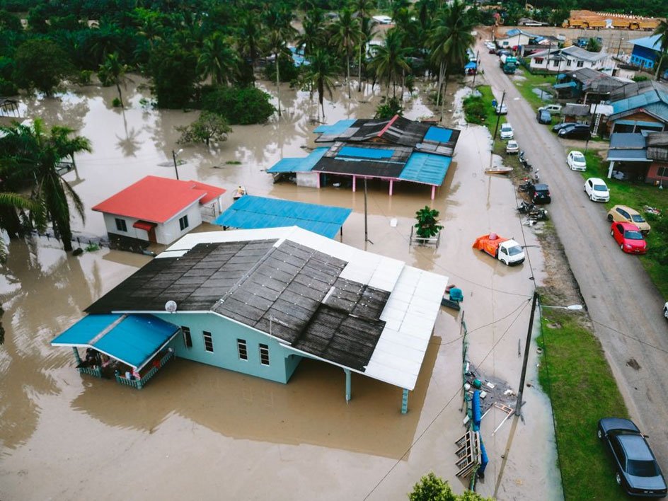
Figure 1.1.10: A flooded village in Malaysia. Source: Pexels
Checklist for Interpreting a Water Problem
Before naming any water problem as scarcity, flood, pollution, or mismanagement, participants should work through a simple hydrological checklist. First, identify the relevant boundary. Is the problem located in a field, a village, a city ward, a lake catchment, an aquifer system, or a river basin? A wrong boundary produces a wrong diagnosis. Second, identify the dominant pathway. Is water moving mainly over the surface, through drains, through soil, through shallow groundwater, through deep aquifers, or through a managed canal or pipe system? Different pathways carry different risks. Surface runoff can carry sediment and pathogens rapidly. Groundwater can carry dissolved nitrate slowly. Canals can transfer water and salinity across landscapes. Third, identify the time scale. Is the problem event-based, seasonal, multi-year, or long-term? Flash flooding, dry-season water shortage, reservoir decline, aquifer depletion, and contaminant persistence all belong to different time scales. Confusing time scales leads to poor interventions, such as treating a long-term depletion problem as if it were a one-year drought. Fourth, identify the storage element that is failing or changing. In some cases, the missing storage is soil moisture. In others, it is floodplain storage, wetland storage, snowpack, reservoir storage, or groundwater storage. The most effective intervention often becomes visible only after the missing or degraded storage function is identified. This checklist is deliberately simple, but it prevents many analytical errors. It trains students to move from a visible symptom to the connected hydrological system that produced it.
1.1.7 Case Studies in Hydrological Connection
Many urban floods are described as drainage failures. This is sometimes true, but it is often incomplete. A city flood is usually the visible expression of a changed catchment. Impervious surfaces increase runoff. Encroached floodplains reduce temporary storage. Drains move water quickly to channels. Filled wetlands remove natural buffers. When intense rainfall occurs, the system has fewer places to hold water. The science is straightforward but often politically difficult: flood risk is not controlled only by the drain at the street corner. It is controlled by land cover, upstream development, channel capacity, floodplain occupation, soil infiltration, solid-waste blockage, rainfall intensity, and the timing of downstream water levels. A purely engineering response may reduce flooding in one locality while shifting risk downstream. This illustrates why hydrological theory matters for administrators and planners. If the problem is interpreted only as insufficient drainage, the solution will be more drains. If the problem is interpreted as loss of catchment storage and accelerated runoff, the response will include land-use control, wetland protection, detention basins, permeable surfaces, and maintenance of drainage systems.
Case Study 1.1-A: Urban Flooding and Catchment Storage — The Chennai Floods of 2015
The floods that inundated Chennai during November–December 2015 are frequently described as the consequence of extreme rainfall. Rainfall was undoubtedly a major triggering factor; however, focusing exclusively on rainfall obscures the hydrological processes that transformed a heavy precipitation event into a large-scale urban disaster. The Chennai case illustrates a fundamental principle of hydrology: floods are not determined by rainfall alone, but by the ability of a catchment to absorb, store, delay, and safely convey water (Sharif et al., 2020).
Historically, the Chennai region consisted of an interconnected system of wetlands, tanks, marshes, floodplains, and seasonal waterways. These landscape elements functioned collectively as a distributed storage network. During intense rainfall, excess water spread across wetlands and low-lying floodplains, slowing runoff and reducing peak discharge. Over time, however, urban expansion altered these hydrological functions. Wetlands were filled for residential and commercial development, lakes were fragmented or encroached upon, drainage channels were narrowed, and impervious surfaces expanded rapidly. Researchers examining the 2015 floods concluded that development on former ponds, lakes, and low-lying areas substantially reduced the city’s capacity to store floodwaters.
The consequence was a profound change in runoff generation. Rainfall that would previously have infiltrated soil or been temporarily stored in wetlands was rapidly converted into surface runoff. Roads, parking areas, rooftops, and paved surfaces acted as hydraulic conduits, accelerating the movement of water toward already overloaded drainage networks. Simultaneously, the loss of wetlands reduced opportunities for temporary retention. The Centre for Science and Environment later argued that protecting lakes alone is insufficient because the catchments and feeder channels supplying those water bodies must also be protected if flood storage functions are to be maintained. An important governance lesson emerged from the disaster. Much of the public discussion initially focused on drainage capacity, leading to demands for larger stormwater drains. Yet hydrological analysis showed that drainage was only one component of the problem. Flood risk was shaped by a combination of catchment modification, wetland loss, land-use change, encroachment of floodplains, solid-waste blockage of drains, and reservoir management decisions. Several studies subsequently emphasized that urban flooding should not be treated solely as a drainage engineering issue but as a catchment-management problem involving land-use planning, environmental regulation, infrastructure maintenance, and hydrological forecasting.
The Chennai case also reveals how flood risk can be socially differentiated. High-income residents often have access to insurance, alternative accommodation, and financial resources for recovery. Informal settlements located in flood-prone zones typically experience greater losses and slower recovery. Small businesses, many of which lack insurance or continuity planning, suffered severe damage when floodwaters entered commercial premises.
Several public commentators and environmental groups argued that the floods were not solely a natural disaster but a consequence of cumulative planning failures. WWF India summarized the issue bluntly when discussing the event, stating that “the Chennai floods of 2015 were not a natural disaster” but were linked to dysfunctional drainage systems and the degradation of wetlands. The hydrological lesson is clear. Urban flood management cannot rely exclusively on drainage expansion. Catchment storage, infiltration, floodplain connectivity, wetland conservation, and land-use regulation are equally important components of flood-risk reduction. Cities that remove storage from their catchments inevitably become more dependent on expensive engineered infrastructure to manage increasingly rapid runoff.
Task for Students: Analytical questions from the case study
Participants should answer the following questions in Forum W-001 under the tag "Case Study 1.1".
- In an urban flood-prone area known to you, which lost storage elements are most important: wetlands, floodplains, open soils, ponds, or drainage maintenance?
- Would Chennai have experienced the same magnitude of flooding if its historic wetland system had remained intact?
- How could a city reduce flood peaks without simply transferring water faster to downstream communities?
Case Study 1.1-B - Springs, Baseflow, and Groundwater Dependence
Springs are places where groundwater returns to the surface. In many mountain and plateau regions, springs support domestic water supply, small irrigation systems, livestock, religious practices, and local ecosystems. A spring may appear as a small local feature, but it represents a larger recharge-discharge system. When springs decline, communities often attribute the change to reduced rainfall alone. Rainfall matters, but so do land cover, recharge zones, road cutting, landslides, groundwater pumping, soil compaction, and changes in vegetation. A spring can decline because the recharge area has changed, because subsurface pathways have been disrupted, or because withdrawals have increased. The practical lesson is that spring management must begin uphill and underground. Protecting only the spring outlet is insufficient if recharge zones are degraded. Conversely, recharge interventions will fail if they are placed where geology does not allow water to reach the spring system. Hydrogeological mapping and community knowledge must therefore work together.
Case Study 1.1-B: Springs, Baseflow, and Groundwater Dependence — Drying Springs in the Indian Himalaya
Across the Himalaya, springs have historically served as the primary source of domestic water for mountain communities. Unlike rivers, which are visible and often receive significant management attention, springs represent the discharge points of groundwater systems that are largely hidden beneath the landscape. Their apparent simplicity can be deceptive. A spring emerging from a hillside may reflect recharge processes occurring hundreds of metres away and months or years earlier. For millions of people in states such as Uttarakhand, Himachal Pradesh, Sikkim, and Nagaland, springs provide drinking water, support livestock, irrigate small agricultural plots, and sustain cultural and religious practices. Yet throughout the Himalayan region, spring discharge has been declining. Numerous springs that once flowed year-round have become seasonal, while others have ceased flowing entirely. Recent assessments suggest that a substantial proportion of Himalayan springs have either degraded or disappeared, affecting water security for large rural populations (Rathod et al., 2021).
The immediate explanation often offered by communities is declining rainfall. Rainfall variability undoubtedly plays a role, but hydrogeological investigations reveal a more complex picture. Changes in land cover, road construction, slope destabilization, urban expansion, deforestation, groundwater abstraction, and altered recharge conditions all influence spring discharge. Roads cut through hillsides can intercept subsurface flow paths. Land-use changes may reduce infiltration. Increased withdrawals can lower groundwater storage. As a result, the decline of a spring often reflects changes occurring throughout an entire recharge area rather than at the spring outlet itself. This insight led to the development of the springshed management approach, which treats springs not as isolated features but as components of broader hydrogeological systems. The central principle is straightforward: if groundwater recharge areas are degraded, protecting only the spring outlet will not restore discharge. Conversely, recharge interventions placed in unsuitable geological settings may fail entirely because infiltrated water does not contribute to the targeted spring system.
Several Himalayan states have begun implementing springshed programmes that combine hydrogeological mapping with community participation. These programmes identify recharge zones, assess groundwater flow pathways, and implement measures such as recharge trenches, infiltration structures, vegetation restoration, and land-use management. Evidence from multiple projects indicates that spring discharge can be partially restored when interventions are designed around actual hydrogeological processes rather than assumptions. Recent discussions among Himalayan water experts have highlighted examples where springshed interventions increased spring discharge by as much as 30 percent. The governance dimensions of spring management are particularly significant. Springs are often managed locally, but the processes controlling them extend beyond administrative boundaries and private landholdings. Recharge areas may lie on forest land, agricultural land, or community commons. Effective management, therefore, requires coordination among local communities, government agencies, hydrogeologists, and land managers.
At a recent Himalayan water conference, experts referred to springs as the region’s “hidden water towers,” emphasizing their importance for nearly 50 million people living in mountain regions. The conference concluded that spring degradation cannot be addressed solely through engineering structures; it requires integrated management of recharge zones, land use, groundwater systems, and community institutions. The Himalayan spring crisis illustrates a broader hydrological lesson. Surface water security is often dependent on groundwater systems that remain poorly understood and weakly governed. When springs decline, the solution is rarely found at the outlet itself. Instead, it is found uphill, underground, and across the landscape that controls recharge.
Mandatory Quiz: [Click Here]
1.1.8 Wrap Up Unit 1.1
Please post a short synthesis in Forum W-001 under the tag "Unit 1.1 Reflection". Your response should include:
- One hydrological connection that you had previously underestimated.
- One practical example from your country or region where groundwater and surface water interact.
- One question you would ask before approving a water development project in a catchment.
Closing Note
Water does not respect the categories by which we administer it. It moves through air, soil, rivers, roots, pipes, wells, and bodies. To study the water cycle is therefore to learn a discipline of connection. Before we can manage water, we must first follow it.
References
IPCC (2021). Climate Change 2021: The Physical Science Basis. Contribution of Working Group
I to the Sixth Assessment Report. Chapter 8: Water Cycle Changes and Chapter 11: Weather and Climate Extreme Events in a Changing Climate. https://www.ipcc.ch/report/ar6/wg1/downloads/report/IPCC_AR6_WGI_Chapter08.pdf
IPCC (2022). Climate Change 2022: Impacts, Adaptation and Vulnerability. Contribution of
Working Group II to the Sixth Assessment Report of the Intergovernmental Panel on Climate Change. Cambridge University Press. Chapter 4: Water. https://www.ipcc.ch/report/ar6/wg2/chapter/chapter-4/
NASA (2010). Overview of the water cycle and climate connections.
https://science.nasa.gov/earth/earth-observatory/the-water-cycle
National Oceanic and Atmospheric Administration (NOAA) (2025). National Water Model
(NWM): Access to NOAA National Water Model data. https://water.noaa.gov/assets/styles/public/images/wrn-national-water-model.pdf
NOAA Northwest River Forecast Center. (n.d.). Description of Hydrologic Cycle.
https://www.nwrfc.noaa.gov/info/water_cycle/hydrology.cgi
Rathod, R., Kumar, M., Mukherji, A., Sikka, A., Satapathy, K. K., Mishra, A., ... & Khan, M.
(2021). Resource book on springshed management in the Indian Himalayan Region: guidelines for policy makers and development practitioners. New Delhi, India: International Water Management Institute (IWMI) New Delhi, India: NITI Aayog, Government of India New Delhi, India: Swiss Agency for Development and Cooperation (SDC). https://tinyurl.com/mrb99amm
Sharif, M., Dhillon, M. S., Chandra, S., Kumar, M., & Vasanthakumar, V. (2020). Urban
flooding—a case study of Chennai floods of 2015. In Smart Cities—Opportunities and Challenges: Select Proceedings of ICSC 2019 (pp. 797-807). Singapore: Springer Singapore. https://doi.org/10.1007/978-981-15-2545-2_64
Stonestrom, D. A., (2011), Estimating groundwater recharge, Eos Trans. AGU, 92(32), 269.
https://doi.org/10.1029/2011EO320008
USGS (2022). Water Cycle resources and diagrams.
https://www.usgs.gov/special-topics/water-science-school/science/water-cycle-diagrams
Winter, T. C., Harvey, J. W., Franke, O. L., & Alley, W. M. (1998). Ground Water and Surface
Water: A Single Resource. USGS Circular 1139. https://pubs.usgs.gov/circ/circ1139/
WMO State of Global Water Resources 2024.