Unit 2.5: Integrated Watershed Management
Instructor: Ms. Syeda Tabassum Tasfia
The transition from water management to watershed management reflects a fundamental shift in how planners and scientists understand the relationship between land, water, and ecosystems. Traditional water management often focused narrowly on supply, distribution, or single-purpose engineering solutions, treating water as a discrete resource to be extracted, stored, or conveyed. Watershed management, by contrast, treats the watershed and the river basin as the natural spatial unit for planning because water moves through connected land surfaces, soils, vegetation, wetlands, streams, and river channels in ways that make upstream and downstream conditions inseparable. River basins provide the larger drainage framework within which catchments and sub-watersheds are nested, and wetlands are not peripheral water bodies within this system but functional components that regulate groundwater recharge, attenuate floods, purify water, and sustain ecological connectivity (Bullock & Acreman, 2003; Acreman & Holden, 2013).
Integrated Watershed Management (IWM) formalises this understanding into a management philosophy and operational framework that coordinates land use, water resources, biodiversity conservation, ecosystem services, and human livelihoods within hydrologically defined boundaries. These components are often difficult to understand or manage effectively in isolation because interactions among hydrological, ecological, and socio-economic processes generate cascading effects across spatial and temporal scales. This unit explores the conceptual foundations and applied dimensions of IWM, including systems thinking, stakeholder participation, adaptive management, land use dynamics, biodiversity conservation, and ecosystem services, thereby building toward the climate resilience and vulnerability discussions addressed in Unit 2.6.
2.5.1: Holistic Approach to Integrated Watershed Management
Integrated Management of Land, Water and Ecosystems
Throughout much of the twentieth century, water resources management was predominantly sectoral, engineering-oriented, and institutionally fragmented. Hydrologists managed streamflow, agricultural agencies focused on crop production and irrigation, forestry departments managed upland vegetation, and fisheries agencies concentrated on aquatic productivity, often with limited coordination among sectors (Biswas, 2004; Global Water Partnership [GWP], 2000). Over time, the limitations of this fragmented approach became increasingly evident. Interventions designed to optimise one sector frequently generated unintended consequences elsewhere in the watershed system. Irrigation schemes contributed to waterlogging and salinisation; deforestation accelerated soil erosion and reservoir sedimentation; urban drainage infrastructure amplified downstream flood peaks; and excessive groundwater abstraction reduced river baseflows and impaired wetland ecosystems (Brooks et al., 2013; GWP, 2000).
Integrated Watershed Management emerged as a response to this fragmentation, recognising that the watershed itself, not administrative boundaries or sectoral mandates, is the most ecologically and hydrologically meaningful unit for coordinated land and water management (Brooks et al., 2013; Organisation of American States [OAS], 1996). IWM may be defined as a coordinated, interdisciplinary, and participatory approach to managing natural resources and human activities within a watershed to balance water availability, water quality, ecosystem integrity, biodiversity conservation, food production, hazard reduction, and livelihood security in a socially equitable, economically viable, and ecologically sustainable manner (GWP, 2000; Brooks et al., 2013). This definition highlights several important characteristics.
First, IWM is explicitly multi-objective because watersheds simultaneously support domestic water supply, agriculture, industry, biodiversity, fisheries, recreation, cultural practices, and climate regulation, and watershed management therefore requires balancing competing objectives rather than maximising a single outcome (GWP, 2000; Brooks et al., 2013). Second, IWM is process-oriented because the legitimacy and effectiveness of management outcomes depend heavily on governance quality, stakeholder participation, transparency, and adaptive learning processes (OAS, 1996; GWP & International Network of Basin Organisations [INBO], 2009). Third, IWM is inherently spatially and temporally nested because processes operating at the plot or field scale influence sub-catchment dynamics, which in turn affect river basin processes, estuaries, and coastal ecosystems through cumulative hydrological and ecological interactions (Brooks et al., 2013).
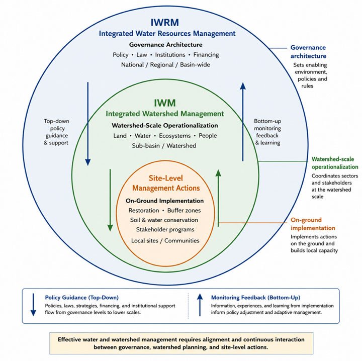
Figure 2.5.1.a. Nested governance framework for integrated water and watershed management, illustrating three interacting scales: Integrated Water Resources Management (IWRM) as the outer governance architecture encompassing policy, law, institutions, and financing at national and basin-wide levels; Integrated Watershed Management (IWM) as the intermediate watershed-scale operationalization coordinating land, water, ecosystems, and people; and site-level management actions as on-ground implementation of restoration, buffer zones, soil and water conservation, and stakeholder programmes. Bidirectional arrows indicate top-down policy guidance and bottom-up monitoring feedback, and learning. Effective management requires continuous alignment across all three scales. (Image courtesy: Syeda Tabassum Tasfia. Original schematic with conceptual framework informed by Global Water Partnership (GWP, 2000) and GWP & INBO (2009).)
The relationship between Integrated Water Resources Management (IWRM) and IWM warrants clarification. IWRM, as defined by the Global Water Partnership (2000), is "a process which promotes the coordinated development and management of water, land, and related resources to maximise economic and social welfare equitably without compromising the sustainability of vital ecosystems" (p. 22). IWM is best understood as the watershed-scale operationalisation of IWRM principles, translating the broader governance framework into site-specific planning and management actions within defined hydrological units such as catchments, sub-basins, and river basins (GWP & INBO, 2009). In this sense, IWRM provides the governance architecture; IWM is the management practice.
A systems perspective treats the watershed not as a collection of independent parts but as an integrated, dynamic socio-ecological system whose behaviour emerges from the interactions among hydrological, geomorphological, ecological, climatic, and human components (Walker & Salt, 2006; Brooks et al., 2013). This perspective has several important implications for watershed management. First, it demands attention to feedback loops, because a management intervention in one part of the watershed may trigger cascading effects elsewhere in the system. For example, agricultural terracing designed to reduce hillslope erosion may decrease sediment delivery to downstream channels, alter channel morphology, influence floodplain inundation patterns, affect wetland hydroperiods, and modify groundwater recharge processes (Brooks et al., 2013; Calder, 2005). Second, systems thinking highlights the importance of temporal lags and non-linear responses. In many humid catchments, forest removal may initially increase annual streamflow because evapotranspiration declines; however, long-term degradation of soil structure and reduced infiltration can subsequently decrease dry-season baseflows and groundwater recharge (Calder, 2005).
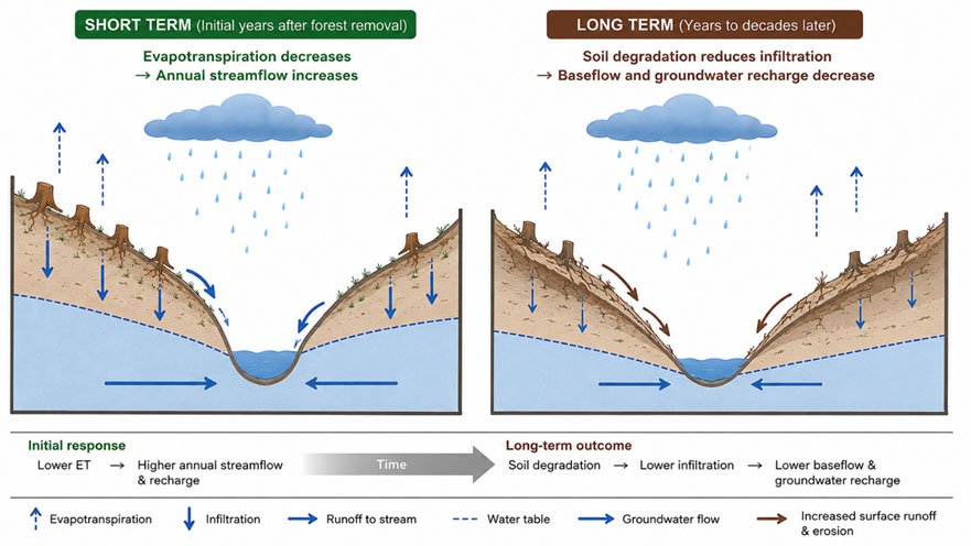
Figure 2.5.1.b: Conceptual illustration showing how forest removal can initially increase streamflow through reduced evapotranspiration, but later decrease infiltration, baseflow, and groundwater recharge as soils degrade (Image courtesy: Syeda Tabassum Tasfia. Original schematic with conceptual framework informed by Calder, I. R. (2005))
Likewise, ecological recovery following wetland restoration may require years or decades because microbial communities, nutrient cycling pathways, and riparian vegetation require time to re-establish (Bullock & Acreman, 2003). Third, systems approaches reveal that gradual environmental change may eventually push the watershed beyond ecological thresholds, producing abrupt and potentially irreversible transitions such as salinisation of irrigated dryland catchments, eutrophication of lakes due to nutrient accumulation, or desertification following vegetation loss in semi-arid watersheds. The resilience literature describes such transitions as shifts between alternative stable states, and emphasises that once critical thresholds are crossed, restoration may become extremely difficult, costly, or uncertain (Walker & Salt, 2006; Groffman et al., 2006).
Finally, systems approaches emphasise cross-scale interactions because local land management decisions aggregate to influence basin-scale hydrology, while regional and global climatic processes shape local watershed dynamics. These interactions are especially evident in transboundary basins such as the Nile, Mekong, and Indus systems, where upstream infrastructure development and water allocation decisions have profound downstream ecological, economic, and geopolitical consequences.
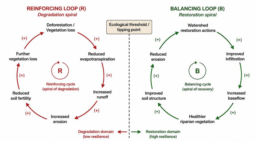
Figure 2.5.1.c: Causal loop diagram illustrating two competing feedback mechanisms in a watershed system: a reinforcing degradation loop (R) in which deforestation reduces evapotranspiration, increases runoff and erosion, depletes soil fertility, and drives further vegetation loss; and a balancing restoration loop (B) in which watershed restoration actions improve infiltration, increase baseflow, support riparian vegetation recovery, and reduce erosion. A dashed ecological threshold/tipping-point separates the degradation domain (low resilience) from the restoration domain (high resilience). All causal links are positive (+), indicating that each change amplifies the next variable in the same direction. Original schematic. Image courtesy: Syeda Tabassum Tasfia. Feedback loop concepts informed by Holling (1973) and Walker & Salt (2006).
Task for Students
Choose a specific watershed management problem in your country or region (e.g., recurring floods, declining water quality, depleted groundwater, fish population collapse). Map out the key components and feedback loops in the system using a simple causal loop diagram. Identify at least one positive (amplifying) and one negative (stabilizing) feedback loop. What does a systems lens reveal about this problem that a single-sector engineering approach would miss? Post your diagram and analysis in Forum W-001.
Watch the Video:
Watch this NPTEL lecture for a detailed academic discussion of watershed systems, feedback loops, cross-scale interactions, and participatory watershed planning. (Courtesy: Prof. Sudip Mitra, IIT Guwahati / NPTEL - CC BY)
References
Acreman, M., & Holden, J. (2013). How wetlands affect floods. Wetlands, 33(5), 773–786.
https://doi.org/10.1007/s13157-013-0473-2
Biswas, A. K. (2004). Integrated water resources management: A reassessment. Water
International, 29(2), 248–256. https://doi.org/10.1080/02508060408691775
Brooks, K. N., Ffolliott, P. F., & Magner, J. A. (2013). Hydrology and the management of
watersheds (4th ed.). Wiley-Blackwell. https://doi.org/10.1002/9781118459751
Bullock, A., & Acreman, M. (2003). The role of wetlands in the hydrological cycle. Hydrology
and Earth System Sciences, 7(3), 358–389. https://doi.org/10.5194/hess-7-358-2003
Calder, I. R. (2005). Blue revolution: Integrated land and water resource management (2nd ed.).
Earthscan.
Global Water Partnership. (2000). Integrated water resources management (TAC Background
Paper No. 4). GWP Technical Advisory Committee. https://www.gwp.org/globalassets/global/toolbox/publications/background-papers/04-integrated-water-resources-management-2000-english.pdf
Global Water Partnership & International Network of Basin Organizations. (2009). A handbook
for integrated water resources management in basins. GWP. https://www.cawater-info.net/bk/iwrm/pdf/gwp-inbo_handbook.pdf
Groffman, P. M., Baron, J. S., Blett, T., Gold, A. J., Goodman, I., Gunderson, L. H., & Wiens, J.
A. (2006). Ecological thresholds: The key to successful environmental management or an important concept with no practical application? Ecosystems, 9(1), 1–13. https://doi.org/10.1007/s10021-003-0142-z
Holling, C. S. (1973). Resilience and stability of ecological systems. Annual Review of Ecology
and Systematics, 4, 1–23. https://doi.org/10.1146/annurev.es.04.110173.000245
Organisation of American States. (1996). Chapter 9: Integrated watershed management [Training
manual]. OAS. https://www.oas.org/cdcm_train/courses/course1/Chapter%209-Integrated%20Watershed%20Management.pdf
Walker, B., & Salt, D. (2006). Resilience thinking: Sustaining ecosystems and people in a
changing world. Island Press.
2.5.2: Stakeholder Involvement
The technical dimensions of integrated watershed management, including hydrological modelling, GIS analysis, remote sensing, ecosystem service valuation, and ecological assessment, are essential but insufficient on their own. Watersheds are ultimately governed through social institutions, political processes, and human decision-making. Farmers, municipalities, industries, indigenous communities, conservation organisations, river basin authorities, and national governments all influence watershed conditions while simultaneously depending upon watershed resources. Consequently, effective IWM requires not only interdisciplinary science but also institutional coordination, participatory governance, and inclusive stakeholder engagement.
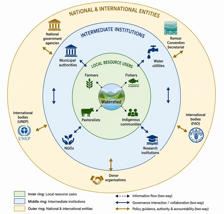
Figure 2.5.2.a: Stakeholder mapping framework for integrated watershed governance, illustrating three concentric tiers of actors: local resource users (inner ring: farmers, fishers, pastoralists, and indigenous communities) who interact directly with watershed resources; intermediate institutions (middle ring: municipal authorities, water utilities, NGOs, and research institutions) that mediate between local and national levels; and national and international entities (outer ring: national government agencies, Ramsar Convention Secretariat, UNEP, FAO, and donor organizations) that set governance frameworks and provide external support. Three types of interaction flows are distinguished: information exchange (dashed arrows), governance interaction and collaboration (solid blue arrows), and policy guidance, authority, and accountability (gold arrows). Effective watershed governance depends on active, two-way engagement across all three tiers. (Image courtesy: Original schematic prepared by Syeda Tabassum Tasfia. Stakeholder typology framework informed by Reed (2008) and Global Water Partnership (GWP, 2000). Note: Institutional logos (Ramsar, UNEP, FAO) are used for educational identification purposes only.)
Community Participation and Institutional Coordination
Stakeholders in watershed management include any individuals, communities, groups, or organisations that influence, or are influenced by, watershed conditions and management decisions. These stakeholders frequently possess divergent interests, unequal political power, and different forms of knowledge. Smallholder farmers influence erosion and runoff through land management practices; urban utilities depend upon upstream watershed conditions for water quality; indigenous communities often maintain place-based ecological knowledge and customary resource governance systems; and sectoral agencies may pursue conflicting objectives related to irrigation, forestry, conservation, infrastructure development, or energy production. The theoretical rationale for stakeholder participation rests on three complementary arguments (Reed, 2008).
First, the epistemic argument recognises that local and indigenous communities often possess detailed knowledge of seasonal hydrology, flood behaviour, traditional water harvesting systems, soil conditions, and historical environmental change that may not be captured in scientific datasets, and incorporating this knowledge improves problem diagnosis and contextual relevance. Second, the legitimacy argument emphasises that decisions affecting shared water resources are more likely to be accepted and implemented when affected stakeholders participate meaningfully in decision-making processes, thereby strengthening procedural legitimacy and social trust. Third, the implementation argument recognises that soil conservation, riparian restoration, grazing management, and pollution reduction measures are generally more effective when communities participate actively in planning, implementation, monitoring, and benefit-sharing processes (Reed, 2008; Newig & Fritsch, 2009).

Figure 2.5.2.b: Collective commitment and collaboration among diverse watershed stakeholders. (Image courtesy Mikael Blomkvist, Pexels.com)
Institutional coordination is the structural counterpart to stakeholder participation. Watershed boundaries rarely coincide with administrative boundaries, creating governance challenges that require coordination across municipalities, provinces, states, and, in some cases, national borders. Coordination mechanisms may include river basin organisations (RBOs), watershed committees, inter-agency planning bodies, or multi-stakeholder governance platforms. Their institutional design strongly influences participation, accountability, conflict resolution, and management effectiveness. Examples from the Global South demonstrate varying governance approaches. India's participatory watershed development programmes under the Integrated Watershed Management Programme emphasised decentralised planning and village-level participation, while South Africa's catchment management agencies were designed to integrate equity, ecological sustainability, and stakeholder representation within post-apartheid water reforms.
Participatory Watershed Management Approaches
Participatory watershed management has evolved substantially since the top-down development projects of the 1970s and 1980s. Contemporary approaches increasingly emphasise co-production of knowledge, in which scientists, government agencies, civil society organisations, and local communities collaboratively define problems, generate knowledge, evaluate alternatives, and monitor outcomes (Norström et al., 2020). Co-production differs fundamentally from purely consultative participation. In consultative processes, local actors may provide input but retain little influence over final decisions. Co-production, by contrast, recognises multiple forms of knowledge as legitimate and seeks shared authority in decision-making, and effective co-production requires explicit attention to power asymmetries, institutional trust, and mechanisms for equitable participation (Norström et al., 2020).
Participatory Rural Appraisal (PRA) and Rapid Rural Appraisal (RRA) methods remain widely used in watershed planning. Common tools include transect walks to observe landscape conditions with community members; seasonal calendars documenting local experiences of floods, droughts, agricultural cycles, and water scarcity; community resource mapping of water sources, degraded areas, and land uses; and problem-ranking exercises to identify locally perceived priorities. A persistent challenge involves the inclusion of marginalised groups. Women, pastoralists, indigenous peoples, landless labourers, and minority communities often experience disproportionate vulnerability to watershed degradation while simultaneously lacking representation in formal governance structures. Gender-responsive watershed planning, therefore, requires deliberate inclusion mechanisms, such as women's representation quotas, accessible meeting schedules, and recognition of differentiated water-use roles (Reed, 2008; Pahl-Wostl, 2009).
Watch the following video for an overview of participatory watershed management principles and practice:
Task for Students
Identify a water governance body (river basin organization, watershed committee, or water user association) operating in your country or region. Based on publicly available information: Who are its members? What decision-making authority does it hold? Are women, indigenous groups, or smallholder farmers represented? Does it function as a genuinely participatory institution or primarily as a consultative mechanism? Post your assessment in Forum W-001.
References
Global Water Partnership & International Network of Basin Organizations. (2009). A handbook
for integrated water resources management in basins. GWP. https://www.cawater-info.net/bk/iwrm/pdf/gwp-inbo_handbook.pdf
Newig, J., & Fritsch, O. (2009). Environmental governance: Participatory, multi-leveland
effective? Environmental Policy and Governance, 19(3), 197–214. https://doi.org/10.1002/eet.509
Norström, A. V., Cvitanovic, C., Löf, M. F., West, S., Wyborn, C., Balvanera, P., Bednarek, A.
T., Bennett, E. M., Biggs, R., de Bremond, A., Campbell, B. M., Canadell, J. G., Carpenter, S. R., Folke, C., Fulton, E. A., Gaffney, O., Gelcich, S., Jouffray, J.-B., Leach, M., ... Österblom, H. (2020). Principles for knowledge co-production in sustainability research. Nature Sustainability, 3(3), 182–190. https://doi.org/10.1038/s41893-019-0448-2
Pahl-Wostl, C. (2009). A conceptual framework for analysing adaptive capacity and multi-level
learning processes in resource governance regimes. Global Environmental Change, 19(3), 354–365. https://doi.org/10.1016/j.gloenvcha.2009.06.001
Reed, M. S. (2008). Stakeholder participation for environmental management: A literature
review. Biological Conservation, 141(10), 2417–2431. https://doi.org/10.1016/j.biocon.2008.07.014
2.5.3: Sustainability and Adaptive Management
The concept of sustainability is central to watershed management, but is frequently applied in vague or inconsistent ways. In watershed contexts, sustainability refers to maintaining the long-term capacity of socio-ecological systems to provide water resources, ecosystem services, biodiversity, food production, and livelihood support across generations while preserving ecological integrity and resilience under conditions of environmental change. Two major challenges complicate sustainable watershed management. The first is intergenerational equity: current management decisions influence the environmental conditions and resource availability inherited by future generations. The second is uncertainty: watershed systems are complex, non-linear, and incompletely understood, particularly under changing climatic and socio-economic conditions.
Principles of Sustainable Watershed Management
The Dublin Principles (1992) remain foundational in global water governance. They combine empirical observations with normative governance commitments by emphasising that freshwater is finite and vulnerable; that water management should be participatory; that women play central roles in water governance; and that water possesses economic value in competing uses. Ecologically sustainable watershed management requires maintenance of environmental flows, also termed ecological flows or e-flows. Environmental flows refer to the quantity, quality, timing, and variability of water required to sustain freshwater ecosystems, estuaries, and associated human livelihoods, and recognition of this requirement has transformed river basin planning because it challenges the assumption that all available water may be allocated to extractive human uses (Arthington et al., 2018). The Brisbane Declaration and Global Action Agenda on Environmental Flows (2018) emphasise that environmental flows are essential for biodiversity conservation, fisheries, sediment transport, cultural values, and ecosystem resilience. Examples from the Murray–Darling Basin in Australia and the Orange-Senqu Basin in southern Africa illustrate the ecological and political complexity of allocating water for ecosystems under conditions of competing agricultural and urban demand. Economic viability constitutes another pillar of sustainability. Watershed management investments, including soil conservation, wetland restoration, green infrastructure, and forest rehabilitation, must often justify their costs through avoided damages, enhanced ecosystem services, or long-term productivity gains. However, conventional cost-benefit analysis frequently undervalues non-market ecosystem services such as biodiversity conservation, flood attenuation, cultural heritage, and climate regulation. Consequently, sustainability assessments increasingly incorporate ecosystem service valuation, multi-criteria analysis, and distributional considerations (Millennium Ecosystem Assessment, 2005).
Adaptive and Learning-Based Management Approaches
Adaptive management emerged from resilience and systems ecology research led by C.S. Holling and colleagues during the 1970s. It recognises that natural resource management occurs under conditions of uncertainty and incomplete knowledge, and rather than treating management plans as fixed prescriptions, it conceptualises management interventions as iterative learning processes. The adaptive management cycle typically involves defining management objectives and hypotheses, implementing interventions, monitoring ecological and social responses, evaluating outcomes relative to predictions, and adjusting management actions based on learning, thereby transforming management into structured learning rather than static control (Williams & Brown, 2012).
In practice, implementing adaptive management is institutionally challenging. Long-term monitoring programmes require sustained financial support and institutional continuity that often exceed political and project cycles. Agencies may also resist acknowledging uncertainty or revising previous decisions, and adaptive governance requires mechanisms capable of integrating new information into collective decision-making processes. The literature distinguishes between passive and active adaptive management. Passive adaptive management relies on monitoring outcomes from selected strategies, whereas active adaptive management deliberately tests alternative management interventions to generate comparative learning. Although active adaptive management produces stronger scientific inference, it requires greater institutional capacity, stakeholder trust, and political tolerance for experimentation (Williams & Brown, 2012). Collaborative adaptive management integrates stakeholder participation into adaptive learning processes, whereby stakeholders contribute to monitoring design, interpretation of results, and revision of management strategies. This approach has been applied in the Murray–Darling Basin in Australia, Pacific salmon restoration programmes in Canada, and transboundary watershed governance initiatives in southern Africa.
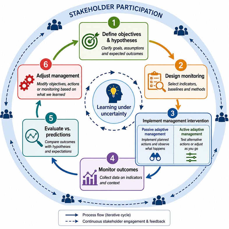
Figure 2.5.2.b: The adaptive management cycle applied to watershed management, illustrating six iterative steps: (1) define objectives and hypotheses; (2) design monitoring by selecting indicators, baselines, and methods; (3) implement management interventions, distinguishing between passive adaptive management (implement and observe) and active adaptive management (design and test alternative interventions); (4) monitor outcomes by collecting data on indicators and context; (5) evaluate outcomes against predictions and hypotheses; and (6) adjust management objectives, actions, or monitoring based on findings. Stakeholder participation and continuous feedback (dashed outer ring) are embedded throughout all stages, and the inner hub represents the core purpose of adaptive management: learning under uncertainty. The cycle then repeats iteratively. (Image courtesy: Original schematic by Syeda Tabassum Tasfia. Adaptive management cycle informed by Williams & Brown (2012).)
Task for Students
"Adaptive management is conceptually powerful but rarely implemented fully in practice." Drawing upon this sub-unit and any watershed case study of your choice, evaluate this statement. What barriers most strongly constrain adaptive watershed governance, and are these barriers primarily technical, institutional, financial, or political? Post your response in Forum W-001.
References
Arthington, A. H., Bhaduri, A., Bunn, S. E., Jackson, S. E., Tharme, R. E., Tickner, D., Young,
B., Acreman, M., Baker, N., Capon, S., Horne, A. C., Kendy, E., McClain, M. E., Poff, N. L., Richter, B. D., & Ward, S. (2018). The Brisbane Declaration and Global Action Agenda on Environmental Flows (2018). Frontiers in Environmental Science, 6, 45. https://doi.org/10.3389/fenvs.2018.00045
Global Water Partnership. (2000). Integrated water resources management (TAC Background
Paper No. 4). GWP Technical Advisory Committee. https://www.gwp.org/globalassets/global/toolbox/publications/background-papers/04-integrated-water-resources-management-2000-english.pdf
Millennium Ecosystem Assessment. (2005). Ecosystems and human well-being: Synthesis.
Island Press. https://www.millenniumassessment.org/en/Synthesis.html
Walker, B., & Salt, D. (2006). Resilience thinking: Sustaining ecosystems and people in a
changing world. Island Press.
Williams, B. K., & Brown, E. D. (2012). Adaptive management: The U.S. Department of the
Interior applications guide. U.S. Department of the Interior. https://www.doi.gov/sites/doi.gov/files/migrated/ppa/upload/Adaptive-Management-Applications-Guide-27.pdf
2.5.4: Land Use, Ecology, and Biodiversity
Land use represents the primary interface between human activity and watershed processes. Agricultural expansion, forest management, grazing systems, mining operations, infrastructure development, and urbanisation all alter hydrological pathways, sediment transport, nutrient cycling, habitat structure, and ecological connectivity, and understanding these linkages is fundamental to integrated watershed management.
Major Land Use Drivers: Agriculture, Forestry, Grazing, Urbanisation, and Mining
Agriculture is among the dominant drivers of watershed transformation globally. Conversion of forests, wetlands, and grasslands into cropland alters evapotranspiration, infiltration, soil structure, and runoff generation. Intensive tillage, mechanised compaction, removal of perennial vegetation, and artificial drainage systems often increase overland flow, erosion, nutrient export, and sediment delivery to streams, although hydrological impacts vary substantially by climate, soil type, crop system, and management practices (Foley et al., 2005). Forestry practices exert equally significant influences on watershed hydrology. Clear-cutting typically reduces transpiration and canopy interception while increasing runoff, erosion risk, and stream temperatures in many forested catchments. Meta-analyses indicate that forest removal often increases annual water yield in humid catchments, although long-term soil degradation and altered infiltration may subsequently reduce dry-season flows (Bosch & Hewlett, 1982). Reforestation and ecological restoration often improve soil structure, infiltration capacity, and sediment retention, although impacts on water yield vary depending on vegetation type, climate, and catchment characteristics. For example, in China's Loess Plateau, large-scale ecological restoration programmes have substantially reduced erosion and sediment export to the Yellow River (Foley et al., 2005).
Urbanisation produces some of the most dramatic hydrological transformations. Impervious surfaces such as roads, rooftops, and parking areas reduce infiltration and increase rapid runoff generation. Urban watersheds often exhibit flashier hydrographs, elevated flood peaks, reduced groundwater recharge, increased thermal pollution, and degraded water quality due to contaminants including hydrocarbons, heavy metals, nutrients, pathogens, and microplastics. The concept of the urban stream syndrome describes the characteristic ecological degradation associated with urbanisation, including altered channel morphology, reduced biodiversity, simplified food webs, and dominance by pollution-tolerant species (Walsh et al., 2005). Green infrastructure approaches such as rain gardens, permeable pavements, bioswales, and constructed wetlands increasingly seek to restore infiltration and attenuate stormwater flows. Mining generates particularly severe localised impacts. Acid mine drainage results from oxidation of sulphide minerals exposed during mining activities, producing acidic runoff capable of mobilising heavy metals and severely degrading aquatic ecosystems. Tailings dam failures, such as the Fundão disaster in Brazil in 2015, demonstrate the catastrophic downstream risks associated with poorly managed mining waste.
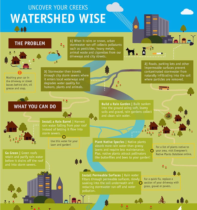
Figure 2.5.2.c: Watershed-scale pollution problems driven by different land uses (left) and rain garden solutions as green infrastructure interventions (right), illustrating the shift from grey to nature-based urban stormwater management. (Image courtesy: https://nicoleczorny.wordpress.com/portfolio/infographics/)
Impacts of Land Use Change on Hydrology, Sediment, and Ecosystems
Land use change influences multiple hydrological and ecological processes simultaneously. Distributed hydrological models such as the Soil and Water Assessment Tool (SWAT) and HEC-HMS are widely used to assess the impacts of land use and climate change on streamflow, erosion, and sediment yield. Empirical studies demonstrate that conversion from natural vegetation to intensive agriculture or urban land uses frequently increases runoff coefficients, peak discharges, and sediment export, although magnitudes vary considerably depending on slope, rainfall intensity, vegetation type, watershed scale, and soil properties (Foley et al., 2005). Excessive sedimentation has major ecological and economic implications. Sediment accumulation reduces reservoir storage capacity, alters channel morphology, degrades spawning habitats, increases turbidity, and transports nutrients and contaminants downstream. Reservoir sedimentation remains a major challenge across South Asia, sub-Saharan Africa, and Latin America, where rapid land-use change often occurs in erosion-prone watersheds (Brooks et al., 2013).
Vegetation–Soil–Water Interactions
Vegetation, soil, and water interact through tightly coupled feedback mechanisms. Vegetation intercepts rainfall, stabilises soil through root systems, enhances infiltration through macropore formation, and regulates evapotranspiration, while soil properties in turn influence infiltration, moisture retention, nutrient cycling, and plant productivity. When vegetation cover is removed through deforestation, overgrazing, drought, or fire, soils become increasingly vulnerable to raindrop impact, aggregate breakdown, crust formation, and erosion. Reduced infiltration increases overland flow and accelerates sediment transport, and in semi-arid regions, these positive feedbacks can drive rapid land degradation and desertification. Such dynamics are evident in parts of the Sahel, western India, and semi-arid Latin America, where vegetation loss and rainfall variability interact to increase hydrological vulnerability (Calder, 2005).
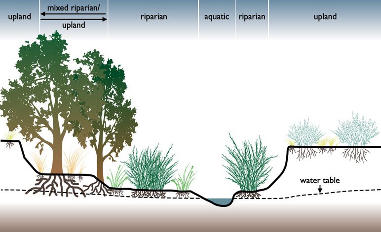
Figure 2.5.2.d: An illustrative diagram of a mixed riparian zone, middle zone, in respect to the aquatic and upland regions. (Image courtesy: Wikipedia, https://upload.wikimedia.org/wikipedia/commons/f/f0/Example_of_a_riparian_area.png)
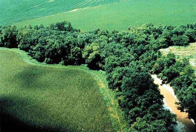
Figure 2.5.2.e: Aerial view of a riparian buffer strip along a winding agricultural stream Image courtesy: Wikipedia, https://upload.wikimedia.org/wikipedia/commons/7/71/Riparian_strip.jpg.
Biodiversity, Riparian Vegetation, and Landscape Connectivity
Riparian zones are among the most ecologically significant landscape elements within watersheds. Although they often occupy relatively small spatial areas, they provide disproportionately important hydrological and ecological functions. Riparian vegetation stabilizes streambanks, filters sediments and nutrients, moderates stream temperatures through shading, contributes organic matter and woody debris to aquatic habitats, and provides movement corridors for terrestrial and aquatic species (Gregory et al., 1991). Landscape connectivity is fundamental to watershed biodiversity. Freshwater systems are longitudinally connected (upstream-downstream), laterally connected (river-floodplain), and vertically connected (surface-groundwater interactions), and human infrastructure such as dams, levees, road crossings, and channelization fragments these connections, disrupting migration pathways, sediment transport, and floodplain processes. GIS-based connectivity assessment tools are increasingly used to identify barriers to ecological connectivity and prioritize restoration actions such as fish passage structures, riparian restoration, and dam removal. Biodiversity contributes directly to watershed functioning, because diverse riparian vegetation enhances filtration efficiency and ecological resilience, and diverse aquatic communities support nutrient cycling, ecosystem metabolism, and trophic stability. Consequently, biodiversity conservation and watershed management are often mutually reinforcing objectives rather than competing priorities.
Task for Students
Select one major land use type discussed in this sub-unit (agriculture, forestry, grazing, urbanisation, or mining). Identify a documented case from your country or region in which this land use altered watershed hydrology, sediment transport, or ecosystem condition. What management interventions were implemented, and how effective were they? Post your analysis in Forum W-001.
References
Bosch, J. M., & Hewlett, J. D. (1982). A review of catchment experiments to determine the
effect of vegetation changes on water yield and evapotranspiration. Journal of Hydrology, 55(1–4), 3–23.
Brooks, K. N., Ffolliott, P. F., & Magner, J. A. (2013). Hydrology and the management of
watersheds (4th ed.). Wiley-Blackwell. https://doi.org/10.1002/9781118459751
Calder, I. R. (2005). Blue revolution: Integrated land and water resource management (2nd ed.).
Earthscan.
Foley, J. A., DeFries, R., Asner, G. P., Barford, C., Bonan, G., Carpenter, S. R., Chapin, F. S.,
Coe, M. T., Daily, G. C., Gibbs, H. K., Helkowski, J. H., Holloway, T., Howard, E. A., Kucharik, C. J., Monfreda, C., Patz, J. A., Prentice, I. C., Ramankutty, N., & Snyder, P. K. (2005). Global consequences of land use. Science, 309(5734), 570–574. https://doi.org/10.1126/science.1111772
Gregory, S. V., Swanson, F. J., McKee, W. A., & Cummins, K. W. (1991). An ecosystem
perspective of riparian zones. BioScience, 41(8), 540–551. https://doi.org/10.2307/1311607
Walsh, C. J., Roy, A. H., Feminella, J. W., Cottingham, P. D., Groffman, P. M., & Morgan, R. P.
(2005). The urban stream syndrome: Current knowledge and the search for a cure. Journal of the North American Benthological Society, 24(3), 706–723. https://doi.org/10.1899/04-028.1
Walker, B., & Salt, D. (2006). Resilience thinking: Sustaining ecosystems and people in a
changing world. Island Press.
2.5.5: Water Resources Management and Ecosystem Services
The ecosystem services framework has become one of the most influential conceptual approaches in environmental management because it links ecosystem functioning directly to human well-being, and within watershed management, it provides scientific, ecological, and economic justification for conserving and restoring watershed systems.
Watershed Ecosystem Services
The Millennium Ecosystem Assessment (2005) classified ecosystem services into four categories: provisioning services, including freshwater, fisheries, food, timber, and fibre; regulating services, including flood regulation, erosion control, water purification, climate regulation, and carbon sequestration; cultural services, including recreation, spiritual values, aesthetic appreciation, and cultural identity; and supporting services, including nutrient cycling, soil formation, primary productivity, and biodiversity maintenance. Although analytically useful, these categories overlap substantially because watershed processes simultaneously generate multiple ecosystem services.

Figure 2.5.5.a: Fishing: a provisioning ecosystem service supplying food and livelihoods (Image courtesy: Rohan Solankurkar, unsplash.com)
Regulating services are particularly important in watershed systems. Wetlands and floodplains attenuate flood peaks; forests stabilize slopes and reduce erosion; riparian buffers filter sediments and nutrients; and intact catchments reduce downstream water treatment costs. However, these benefits frequently remain economically invisible because ecosystem services are often public goods whose benefits accrue downstream or across society rather than directly to upstream land managers (Millennium Ecosystem Assessment, 2005). Carbon sequestration has become increasingly important in watershed conservation because forests, peatlands, and grasslands store substantial amounts of carbon in biomass and soils, and peatland conservation in Southeast Asia and mangrove restoration in coastal tropical watersheds illustrate the strong links among watershed management, biodiversity conservation, and climate mitigation (Millennium Ecosystem Assessment, 2005).
Trade-offs Between Development and Ecosystem Conservation
Watershed management decisions often involve trade-offs among ecosystem services. Agricultural expansion may increase food production while reducing flood regulation and biodiversity. Hydropower dams may enhance energy security while disrupting sediment transport, fish migration, and floodplain ecology. The water-energy-food nexus framework highlights these interdependencies because irrigation, hydropower generation, domestic supply, and industrial production frequently compete for limited water resources, and sector-specific optimisation often produces undesirable watershed-scale outcomes that require explicit recognition of trade-offs, cumulative impacts, and distributional consequences (Millennium Ecosystem Assessment, 2005).
Payments for Ecosystem Services (PES)
Payments for Ecosystem Services (PES) seek to align economic incentives with watershed conservation objectives. In watershed PES schemes, downstream beneficiaries such as municipalities, hydropower operators, or water utilities compensate upstream land managers for practices that improve or maintain watershed services (Wunder, 2015). Costa Rica's PSA programme is widely regarded as one of the most influential PES initiatives, although debate continues regarding its additionality and long-term social equity outcomes. Since the late 1990s, payments financed through fuel taxes and water tariffs have supported forest conservation and reforestation activities, contributing to watershed protection and biodiversity conservation. China's Sloping Land Conversion Program and watershed restoration initiatives in Latin America and East Africa also illustrate large-scale efforts to integrate ecosystem services into land management policy (Salzman et al., 2018). Nevertheless, PES implementation faces important challenges. Demonstrating causal relationships between upstream land management and downstream hydrological services can be scientifically difficult because multiple interacting variables, including climate variability, geology, soils, and spatial scale, influence watershed responses. Institutional challenges include monitoring, verification, equitable benefit distribution, land tenure insecurity, and long-term financial sustainability (Wunder, 2015; Salzman et al., 2018).
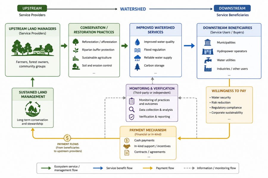
Figure 2.5.2.f: Conceptual structure of a watershed Payment for Ecosystem Services (PES) mechanism. Upstream land managers (farmers, forest owners, community groups) implement conservation and restoration practices, including reforestation, riparian buffer protection, sustainable agriculture, and soil and erosion control, which generate improved watershed services (water quality, flood regulation, reliable water supply, and carbon storage) for downstream beneficiaries (municipalities, hydropower operators, water utilities, and other users). Downstream beneficiaries' willingness to pay is motivated by water security, risk reduction, regulatory compliance, and corporate sustainability goals. Funds for the payment mechanism (financial or in-kind), which flow back upstream to sustain long-term land management. Monitoring and verification by independent third parties provides the information flows that link service delivery to payment conditionality. (Image courtesy: Original schematic by Syeda Tabassum Tasfia). Conceptual framework informed by Wunder (2015) and Salzman et al. (2018).)
Task for Students
Consider a proposed water-related infrastructure project in your country, such as a dam, irrigation scheme, urban expansion project, or water transfer initiative. Using the ecosystem services framework, identify: which ecosystem services are likely to increase; which services are likely to decline; which social groups or regions gain or lose; and whether a PES mechanism could help address trade-offs. Post your response in Forum W-001.
Mandatory Quiz: [Click Here]
References
Millennium Ecosystem Assessment. (2005). Ecosystems and human well-being: Synthesis.
Island Press. https://www.millenniumassessment.org/en/Synthesis.html
Salzman, J., Bennett, G., Carroll, N., Goldstein, A., & Jenkins, M. (2018). The global status and
trends of payments for ecosystem services. Nature Sustainability, 1(3), 136–144. https://doi.org/10.1038/s41893-018-0033-0
Wunder, S. (2015). Revisiting the concept of payments for environmental services. Ecological
Economics, 117, 234–243. https://doi.org/10.1016/j.ecolecon.2014.08.016