Unit 2.2 Watershed Planning Survey and Planning
Instructor: HG/Er. Sabina Khatri
In this Unit 2.2, we will examine the foundational methodologies of watershed surveying and the systemic process of watershed planning. Without rigorous surveying, watershed management devolves into guesswork. A watershed survey involves the systematic collection and analysis of data related to topography, hydrology, geology, soils, land use, vegetation, climate, and socio-economic conditions within a drainage basin. This information identifies resource potentials, environmental constraints, and key challenges such as soil erosion, water scarcity, flooding, and land degradation. Watershed planning utilizes these survey findings to develop integrated management strategies that promote water conservation, enhance groundwater recharge, improve agricultural productivity, and protect ecosystems. By adopting a holistic and participatory approach, watershed planning aims to optimize resource utilization while ensuring long-term environmental sustainability and resilience to climate change.
2.2.1. Watershed Planning
Watershed planning stands as one of the most powerful operational expressions of Integrated Water Resources Management (IWRM), transforming high-level principles into concrete, landscape-specific action. In its most advanced form, it is not merely a technical exercise but a deliberate reimagining of entire river basins as interconnected socio-ecological systems. Within this framework, land, water, people, and ecosystems are no longer treated as separate domains but as interdependent components of a single functioning whole. Watershed planning therefore becomes the operational bridge between theory and practice, translating sustainability ideals into structured, place-based strategies that directly shape how communities interact with water resources.
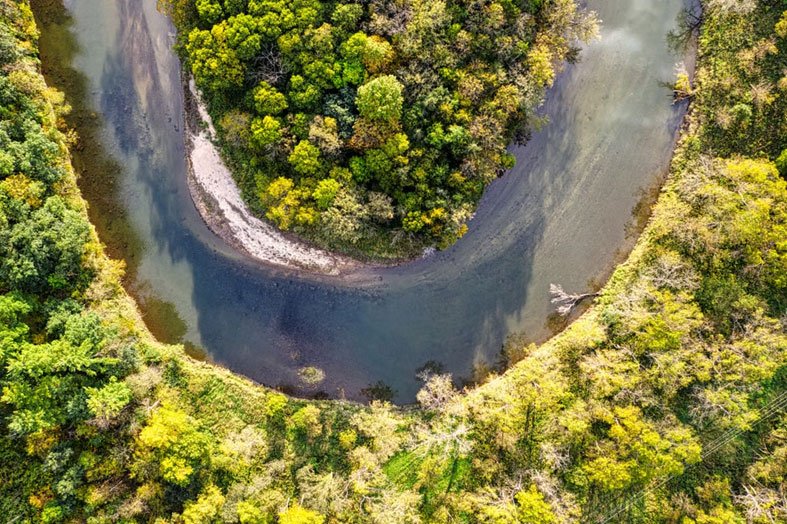
Figure 2.2.1.a. An Ox bow lake formed from a river. Source: Pexels (open access)
Historically, water management was fragmented into isolated silos, each discipline operating almost as if it inhabited a separate universe. Civil engineers focused narrowly on drainage channels and flood conveyance, biologists monitored aquatic species and habitat conditions, and urban planners drew zoning maps with little regard for upstream hydrological consequences. Decisions were made in isolation, often optimizing one component of the system while unintentionally degrading another, as though rivers respected departmental boundaries or ecosystems paused at administrative borders. The modern watershed approach shatters this outdated worldview by revealing a fundamental truth: everything within a watershed is profoundly interconnected. Water does not negotiate with human institutions; it flows relentlessly across landscapes, carrying sediments, nutrients, pollutants, and the consequences of human action from the highest mountain ridge to the lowest coastal estuary. A single oil spill in an upland stream, a patch of deforestation, or an intensification of agriculture can cascade downstream, amplifying impacts across entire regions. In this sense, the watershed behaves less like a collection of separate parts and more like a single, living hydrological organism, where every action reverberates through the whole system.
This interconnected reality demands an integrated form of management that is both holistic and adaptive, capable of addressing problems at the scale at which they actually occur. Watershed planning allows us to confront the most elusive and complex challenge in water governance: non-point source pollution. Contaminants in these scenarios emerge not from a single identifiable pipe, but from millions of diffuse sources such as farms, roads, parking lots, and urban surfaces. Unlike a factory discharge, there is no single valve to turn off, no single culprit to regulate. The entire landscape becomes both the source and the solution, requiring coordinated land-use planning, behavioral change, and systemic thinking that treats the watershed not as a boundary to manage, but as a unified ecological system to steward.
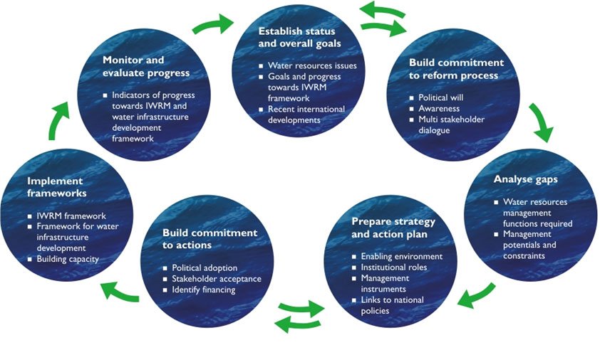
Figure 2.2.1.b. IWRM Planning Cycle (Source: Global Water Partnership (2000). Integrated Water Resources Management (TAC Background Paper No. 4).)
At its core, watershed planning is a systematic and evidence-driven process designed to manage land and water resources in a manner that is simultaneously sustainable, efficient, and equitable. This process begins with detailed watershed surveys that map hydrological patterns, land use dynamics, soil characteristics, and ecological conditions using tools such as GIS, remote sensing, and field-based assessments. Yet it extends far beyond biophysical science. It incorporates institutional structures, governance mechanisms, and community-level realities, recognizing that water systems cannot be managed effectively without understanding the diverse stakeholders who depend on them. To counterbalance purely technical tendencies, Parkes et al. (2019) introduced The Adaptive Watershed (TAW) through the International Institute for Sustainable Development (IISD). TAW serves as a capacity development tool to assist watershed stakeholders in constructing and implementing plans. Using ecosystem management and adaptive management concepts, TAW emphasizes action and inclusion to generate resilience to climate change scenarios, incorporating adaptability to shifting political, environmental, social, and economic landscapes.
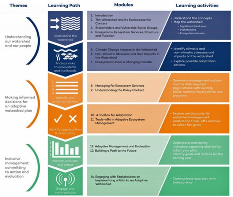
Figure 2.2.1.c. Logical flow of The Adaptive Watershed’s (TAW’s) approach to capacity development. Source: Parkes et al. (2019). Water, 11(4), 662.
TAW fuses rigorous biophysical analysis with socio-economic understanding to ensure interventions are technically robust, socially legitimate, and environmentally resilient. It evaluates trade-offs between agricultural productivity, ecosystem protection, urban development, and long-term water security. TAW operates through three themes (Figure 2.2.1.b): (a) Understanding our watershed and our people, (b) making informed decisions, and (c) inclusive management: Committing to action and evaluation. These are implemented across 14 modules designed to advance collaboration. From soil conservation terraces in upland farms to floodplain restoration in downstream cities, every intervention is guided by integrated knowledge of the entire basin system.
A contrasting but complementary approach is the Watershed Health Assessment Framework (WHAF), developed by the Minnesota Department of Natural Resources (MDNR, 2018). WHAF is a comprehensive GIS-based visualization and data analysis tool designed to evaluate the overall condition or "health" of watershed systems. It moves beyond single-variable assessments of water quality or quantity, adopting a holistic approach that considers how well a watershed functions as an interconnected system. WHAF combines indicators such as hydrologic regime integrity, water quality status, aquatic habitat condition, connectivity of waterways, and landscape stressors like land-use change.
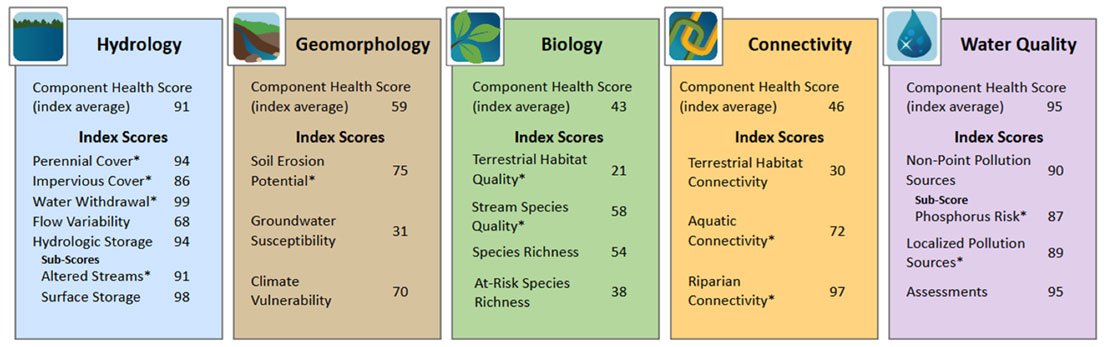
Figure 2.2.1.d. Examples of Watershed Health Assessment Framework (WHAF) health scores from the Pine River Watershed, Minnesota (MDNR WHAF, 2018).
WHAF components are scored using a three-tier system, ranging from 0 (unhealthy/increased impairment) to 100 (healthy/lack of impairment). The primary component is watershed health, derived from the average of five second-tier scores: Biology, connectivity, geomorphology, hydrology, and water quality. These are, in turn, derived from third-tier index scores based on GIS variables collected by public agencies. This framework translates complex environmental data into accessible indices that guide restoration priorities, land-use planning, and conservation strategies. It helps identify relationships between human activities and watershed responses, proving particularly useful for evaluating the impacts of urbanization, agriculture, and climate variability. Ultimately, WHAF serves as a decision-support system enabling managers to track changes over time, assess cumulative impacts, and implement targeted interventions.
The suite of watershed planning tools integrating IWRM principles—simulation models, optimisation models, hydro-economic frameworks, geospatial technologies, WHAF, and TAW—represents a significant shift away from traditional silo-based practices. Modern watershed planning overcomes historical limitations by adopting a systems-oriented approach where hydrological processes, ecological functions, and socio-economic dynamics are analysed in an integrated framework. Together, these tools enable a coordinated, evidence-based, and adaptive form of decision-making that replaces fragmented thinking with integrated management.
Participatory Exercise (Forum W-001)
Before proceeding further, every participant is requested to contribute to Forum W-001 under the discussion thread "Planning Failures in My Watershed".
Briefly describe one watershed planning challenge from your own country or region. Do not restrict yourself to flooding alone. You may discuss urban expansion into floodplains, river encroachment, groundwater recharge failures, poor watershed zoning, wetland loss, agricultural runoff, institutional conflicts, failure of watershed restoration projects, etc. The objective is to appreciate that watershed planning problems are rarely technical alone; they usually emerge from governance failures.
Task for Instructor / Facilitator
Monitor the Forum W-001 throughout the week. Summarise the most common planning problems identified by participants and integrate selected examples into the discussion during the livestream session and Case Studies presented later in this unit.
Task and Instructions for Students
Before continuing, all students are advised to watch the following open-access educational videos. These videos describe the foundational concepts of watershed delineation and the application of spatial modeling tools in planning.
Essential Watch
Climate Change and Water Resources
Additional Watch
Watershed Management Planning
While watching, consider:
How can my land management choices help 'slow, spread, and sink' water to restore the natural hydrological cycle and build landscape resilience?
While watching, ask yourself:
Which stakeholders are included in the planning process, and who appears to be missing?
Read the Bare Fact
Planning failures are rarely caused by the absence of scientific knowledge. More commonly, they occur because scientific knowledge is separated from planning institutions, because agencies work independently of one another, or because political decisions override hydrological realities. Watershed degradation therefore represents a failure of integration rather than a failure of hydrology. Across the world, flood control agencies often work independently from groundwater authorities. Agricultural departments encourage irrigation expansion without considering downstream environmental flows. Urban planning permits development on floodplains while disaster management agencies spend increasing resources responding to floods that those same planning decisions helped create. A watershed does not recognise institutional boundaries. Yet governments frequently do. This disconnect explains why technically sound watershed plans sometimes fail during implementation. Planning is not merely about producing maps and reports. It is equally about coordinating institutions, reconciling competing interests, and maintaining ecological functions while accommodating development. The Global Water Partnership (2000) defines Integrated Water Resources Management as:
"A process which promotes the coordinated development and management of water, land and related resources in order to maximize economic and social welfare in an equitable manner without compromising the sustainability of vital ecosystems."
Compare this definition with many existing watershed plans in your own country. Do they genuinely coordinate land, water, biodiversity, agriculture and urban planning? Or do they simply assemble reports prepared independently by different departments?
2.2.2. The Watershed Planning Survey
In watershed management, the survey is the diagnostic foundation upon which every planning decision depends. Before a watershed can be restored, protected, or developed, planners must first understand how it functions (Cao et al., 2022). A watershed survey is therefore not simply the collection of environmental data; it is a systematic investigation into the hydrological, ecological, geomorphological, social, and economic processes operating across an entire drainage basin. Poor surveys inevitably produce poor plans. Conversely, comprehensive surveys allow managers to identify opportunities for restoration, anticipate future risks, and allocate resources where interventions will produce the greatest long-term benefit. Unlike conventional engineering surveys that often focus on a single project site, watershed surveys examine an interconnected landscape. Water flowing through a watershed carries sediment, nutrients, contaminants, energy, and biological organisms across administrative boundaries. Consequently, a change observed at one location may be the consequence of activities occurring many kilometres upstream. The survey therefore seeks not only to measure conditions but also to explain relationships between different components of the watershed system. Modern watershed surveys integrate information from hydrology, geomorphology, ecology, climatology, agriculture, economics, engineering, sociology, and governance. Increasingly, these disciplines are supported by Geographic Information Systems (GIS), remote sensing, digital elevation models, drone-based observations, hydrological modelling, and participatory mapping conducted with local communities. The survey therefore becomes a multidisciplinary exercise that combines quantitative measurements with local knowledge to produce an evidence base for adaptive management. Rather than treating data collection as an isolated technical activity, contemporary watershed planning recognises surveys as iterative processes. As new information becomes available through monitoring, climate observations, or stakeholder consultation, survey databases are updated, allowing watershed plans to evolve alongside changing environmental conditions.
Physical and Topographic Assessment: Modern watershed surveys combine traditional field methods with advanced technologies such as remote sensing and Geographic Information Systems (GIS). Satellite imagery enables large-scale assessment of land cover and change over time, while GIS facilitates spatial analysis and integration of multiple datasets. Critical tasks include precise delineation—marking the ridges and high points that determine water flow direction—and geomorphological study. Analyzing the shape of river channels reveals stability; a river that is "downcutting" or widening is often a symptomatic indicator of upstream land-use changes. Hydrological data collection forms another critical component. Streamflow measurements, rainfall records, groundwater levels, and water quality parameters are required to understand flow regimes and variability. According to Ward and Trimble (2004), accurate hydrological data are indispensable for identifying erosion-prone areas, flood risks, and water availability constraints. In data-scarce regions, planners often rely on proxy indicators, modelling, and participatory knowledge from local communities.
Information Box
Core Datasets Required for Modern Watershed Planning: A scientifically robust watershed survey should ideally integrate the following datasets before planning begins.
Table 2.2.1
| Physical | Ecological | Socio-economic | Governance |
| Digital Elevation Model | Land Cover | Population | Administrative Boundaries |
| River Network | Riparian Vegetation | Livelihoods | Water Rights |
| Rainfall | Biodiversity | Agriculture | Institutional Responsibilities |
| Streamflow | Wetlands | Irrigation | Protected Areas |
| Groundwater Levels | Habitat Connectivity | Industry | Existing Plans |
| Soils | Water Quality | Infrastructure | Disaster Management Plans |
The Chemical Inventory: Here we are measuring the invisible properties of the water. Water quality assessment goes beyond simply measuring H2O; it involves tracking the invisible chemical signals that reveal ecosystem health. This chemical inventory allows scientists to measure what cannot be seen and diagnose the ecological condition of a watershed, relying on key parameters:
- Nutrient Loading: High levels of Nitrogen and Phosphorus (often from fertilizers) that cause eutrophication and "dead zones."
- Dissolved Oxygen (DO): The "breath" of the water. If the DO levels fall too low (typically < 5 mg/L for many species), aquatic life suffocates.
- Conductivity and pH: These indicators detect industrial runoff, salinity intrusion, or acid mine drainage.
- Modern watershed programmes increasingly combine laboratory sampling with continuous monitoring sensors, automatic samplers, satellite observations and biological indicators that integrate environmental conditions over much longer periods.
Dissecting the Limits of Chemical Snapshots
Chemical measurements are inherently limited. They represent momentary snapshots of water quality, capturing conditions only at the exact moment a sample is drawn. A river might test clean on a Tuesday but carry lethal pollutant pulses on a Wednesday following a heavy rain event. Because of this temporal limitation, reliance on chemistry alone provides an incomplete picture of watershed health. To understand chronic, long-term conditions, we must look to the organisms that live within the system. Chemical data therefore answer an important question: “What is happening today?”. Biological communities answer a different question: “What has been happening here over the past months or years?” “What has been happening here over the past months or years?”
Biological Integrity (The Bio-Survey): Biological communities act as continuous monitors, reflecting conditions over extended periods. Surveying benthic macroinvertebrates—such as dragonfly larvae, mayflies, and stoneflies—provides a robust assessment of long-term watershed health. These organisms are classified according to their tolerance to pollution, sedimentation, and low dissolved oxygen levels. Sensitive species are typically reduced or eliminated under degraded conditions, while pollution-tolerant species persist or become dominant. The absence of sensitive taxa serves as direct evidence of chronic environmental stress. By analysing species diversity, abundance, and community composition, an integrated and time-averaged evaluation of ecological integrity is obtained, surpassing what chemical testing alone can provide.
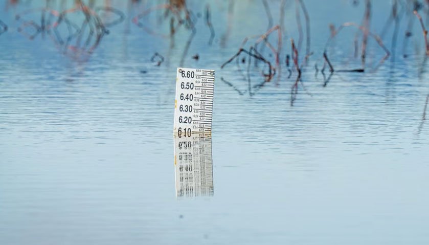
Figure 2.2.2.a. Water level gauge, a ruler-style tool designed for monitoring flood levels and water depths. Source: Pexels (Open access)
Socio-economic Survey: Effective watershed planning requires looking beyond physical data to understand socio-economic conditions. Population dynamics, livelihoods, land tenure, and institutional arrangements shape both water demand and management capacity. Participatory methods such as community mapping, focus group discussions, and stakeholder consultations capture local knowledge and priorities. Chambers (1994) argues that participatory approaches not only improve data quality but also foster ownership and long-term commitment to watershed interventions. Once baseline information is compiled, the planning phase begins. This phase is inherently iterative and multidisciplinary. Frameworks such as the DPSIR (Drivers-Pressures-State-Impact-Response) model (European Environment Agency, 1999) help planners conceptualise cause-effect relationships within the watershed system and design targeted responses. Spatial planning plays a central role here; GIS-based analysis allows planners to delineate sub-watersheds, identify critical source areas, and optimise the placement of interventions such as soil conservation structures or recharge zones. Burrough and McDonnell (2015) note that spatial decision support systems enhance transparency and analytical rigour in complex basins.
Climate change considerations are increasingly integrated into this process. Changes in rainfall patterns, temperature, and extreme events alter hydrological regimes and exacerbate existing vulnerabilities. Adaptive planning approaches emphasise flexibility, scenario analysis, and resilience-building measures. According to IPCC (2023) assessments, watershed-scale planning is particularly effective for climate adaptation because it aligns natural processes with human management strategies, ultimately harmonising development and conservation objectives.
Read the Bare Fact
Watershed degradation is rarely caused by one catastrophic event. More often it represents the cumulative consequence of thousands of individually insignificant decisions. A farmer clears a small forest patch, a municipality approves one more housing development, A road is constructed across a drainage channel, a wetland is gradually filled, and groundwater abstraction increases slightly each year. Each action appears negligible when viewed independently. Collectively, they reorganise the hydrology of an entire watershed. By the time rivers begin flooding more frequently or streams cease flowing during the dry season, the planning failures responsible may have accumulated over decades. The survey therefore performs a second function beyond measuring the present: it reconstructs the history that produced today's watershed.
Mandatory Quiz: [Click Here]
Case Study 2.2-A: Limpopo River Basins (Africa) Living Labs: Limpopo River Basin
Instructions: All students should read the following case study below and answer the questions that follow in brief. Link:
Post your answers to the following questions in the Forum W-001:
- What is the primary objective of the research program supported by the CGI Challenge Program?
- What is the primary objective of the research program supported by the CGI Challenge Program?
- Why is the involvement of local farmers considered the 'backbone' of this research project?
Case Study 2.2-B: Reading Exercise
Instructions
Download the PDF files for the Sukhomajri Watershed Project (India) and the New York City Watershed Protection Program (USA). Read and contrast how a developing-nation community-driven survey approach compares to a developed-nation urban payment-for-ecosystem-services planning model.
Post your answers to the following questions in the Forum W-001:
- What is meant by "Social Fencing" in the Sukhomajri Project?
- Name two major watershed interventions implemented in the Sukhomajri Project.
- Name two major watershed interventions implemented in the Sukhomajri Project.
Final Reflection Question for Students
"If you were responsible for managing a watershed under increasing climate variability, how would you combine watershed surveys, GIS, stakeholder participation, TAW principles, and watershed health assessments to develop a sustainable management plan?"
References
Burrough, P. A., & McDonnell, R. A. (2015). Principles of Geographical Information
Systems. Oxford University Press. Google Book
Cao, Z., Wang, S., Luo, P., Xie, D., & Zhu, W. (2022). Watershed Ecohydrological Processes
in a Changing Environment: Opportunities and Challenges. Water, 14(9), 1502. https://doi.org/10.3390/w14091502
Chambers, R. (1994). Participatory rural appraisal (PRA): Analysis of experience. World
Development, 22(9), 1253–1268. https://doi.org/10.1016/0305-750X(94)90003-5
European Environment Agency (EEA). (1999). DPSIR Framework Environmental Indicators:
Typology and Overview. Technical Report No. 25. https://www.eea.europa.eu/publications/TEC25
Global Water Partnership. (2000). Integrated Water Resources Management (TAC
Background Paper No. 4). Stockholm, Sweden. https://www.gwp.org/globalassets/global/toolbox/publications/background-papers/04-integrated-water-resources-management-2000-english.pdf
Intergovernmental Panel on Climate Change (IPCC). (2023). Climate Change 2023: Synthesis
Report. https://www.ipcc.ch/report/ar6/syr/
International Institute for Sustainable Development (IISD). (2018). The Adaptive Watershed:
A Planning and Capacity Development Framework for Watershed Management.https://www.iisd.org
Minnesota Department of Natural Resources (MDNR). (2018). Watershed Health Assessment s
Framework (WHAF): User Guide and Technical Documentation.https://www.dnr.state.mn.us/whaf/index.html
Parkes, M. W., Morrison, K. E., Bunch, M. J., Hallström, L. K., Neudoerffer, R. C., Venema,
H. D., & Waltner-Toews, D. (2019). Towards integrated governance for water, health and social-ecological systems: The Adaptive Watershed framework. Water, 11(4), 662. https://doi.org/10.3390/w11040662
Perry, J., & Thompson, L. (2019). Empowering the Next Generation of Watershed Decision-
Makers: A Pedagogical Design. Water, 11(4), 662. https://doi.org/10.3390/w11040662
Ward, A. D., & Trimble, S. W. (2004). Environmental Hydrology (2nd ed.). CRC Press.