Unit 2.1 Principles of Water Management in the Watersheds
Instructor: HG/Er. Sabina Khatri
In this unit, we examine how water is managed within watershed boundaries. The shift from science to management is not merely a change of topic. It is a change in logic. Science describes systems; management intervenes in them. Intervention, as we shall see, is far more complicated than description.
2.1.1 Water and Water Cycle
Earth functions as a coupled system in which water connects the atmosphere, hydrosphere, lithosphere, and biosphere. Water continuously moves between these spheres through evaporation, condensation, precipitation, infiltration, and runoff. This movement regulates climate, shapes landscapes, and supports biological processes. About 71 percent of Earth's surface is water-covered, but the distribution is starkly uneven: oceans hold roughly 96.5 percent of all water, and freshwater available for human use constitutes a fraction of one percent.
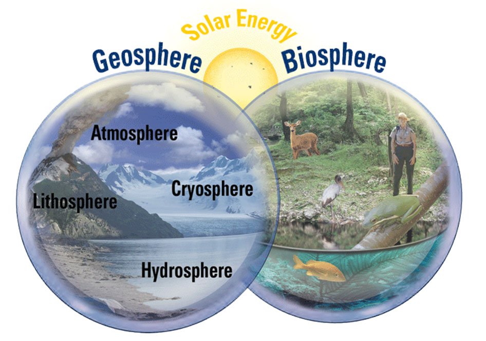
Figure 2.1.1.a Two main systems of the Earth: The Geosphere and The Biosphere. Image Source: James A. Tomberlin, USGS
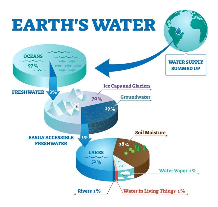
Figure 2.1.1.b Composition of Earths water [Copyright: normaals]
The Earth is a watery place. But just how much water exists on, in, and above our planet? About 71 percent of the Earth's surface is water-covered, and the oceans hold about 96.5 percent of all Earth's water. Water also exists in the air as water vapour, in rivers and lakes, in icecaps and glaciers, in the ground as soil moisture and in aquifers, and even in you and your dog.
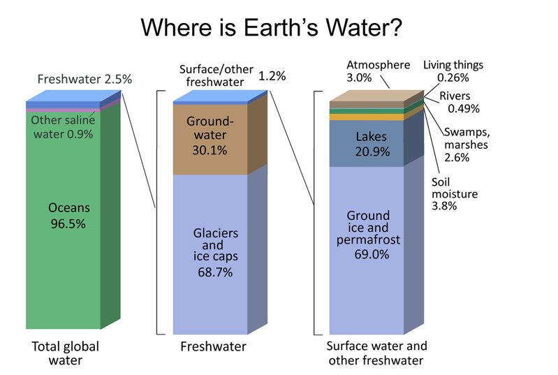
Figure 2.1.1.c Water Distribution of the World (Source: Igor Shiklomanov's chapter "World fresh water resources" in Peter H. Gleick (editor), 1993, Water in Crisis: A Guide to the World's Fresh Water Resources.)
Water acts as both a resource and a transport medium. It carries nutrients, minerals, and energy across ecosystems. Oceans, rivers, lakes, glaciers, groundwater, and the atmosphere form an interconnected network storing and circulating water globally. Human activities — agriculture, urbanization, industry — alter the natural movement and quality of water, making the water cycle not merely a natural process but a socio-hydrological one. Understanding water in Earth as a closed system helps explain how natural processes are interconnected and why maintaining the balance of that system matters.
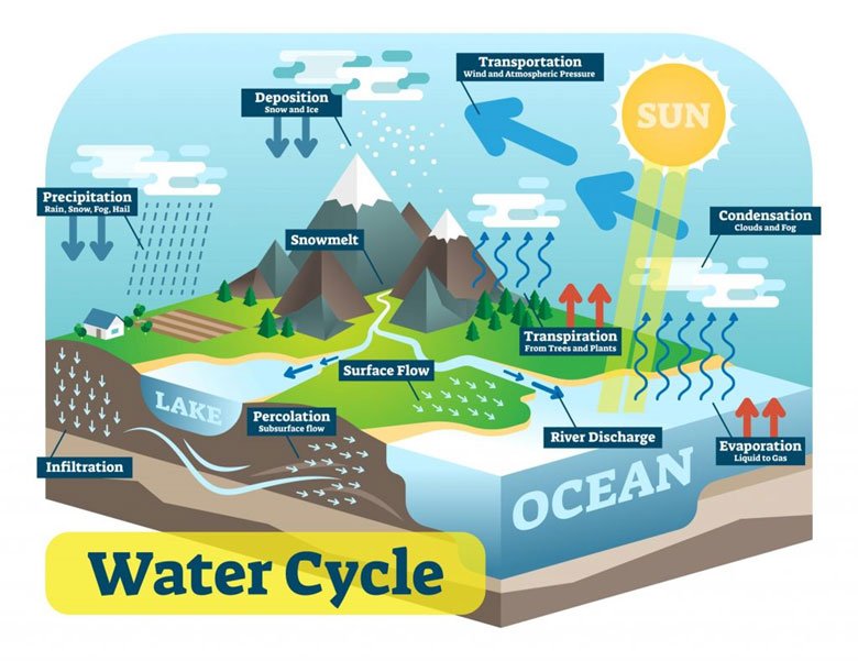
Figure 2.1.1.d. The Water Cycle [Source: normaals]
A watershed, also called a drainage basin or catchment, is the naturally defined geographic region where all precipitation and surface runoff converge toward a common outlet — a river, lake, reservoir, estuary, or ocean. Boundaries are determined by topographic divides, or ridgelines, separating one drainage area from another. Any rainfall within the watershed ultimately contributes to flow toward the designated outlet through interconnected surface and subsurface pathways. Headwaters form the uppermost portions where streams originate and play a critical role in maintaining streamflow and water quality. Tributaries contribute flow to larger channels. Confluences mark points where streams merge, increasing discharge and altering hydrological characteristics. Outflows are the final discharge points where water enters a larger receiving body. Watersheds range from small local drainage areas associated with streams or wetlands to vast river basins like the Amazon or the Mississippi that influence regional hydrology, ecosystems, and socioeconomic activities.
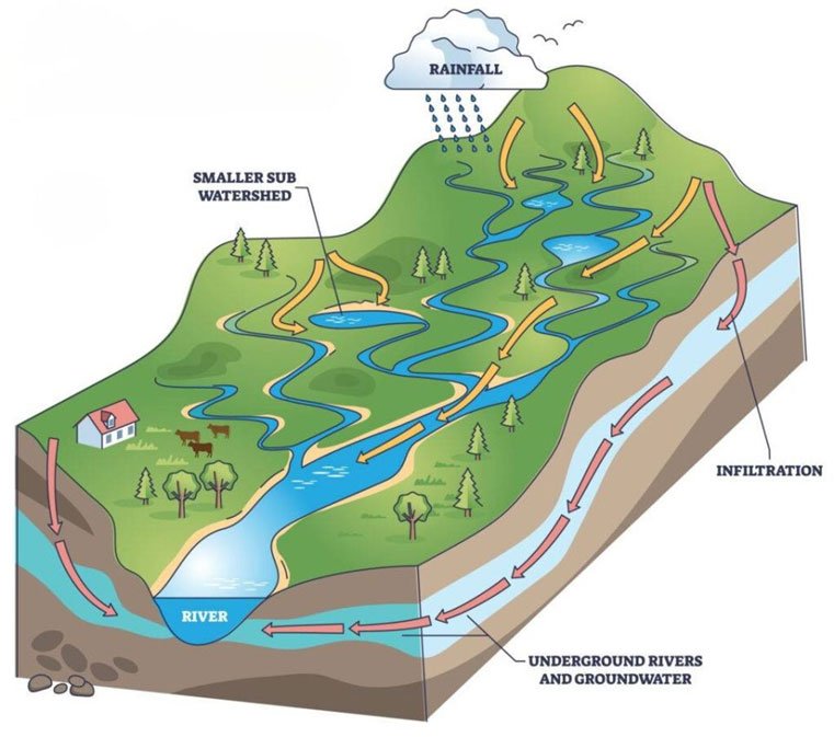
Figure 2.1.1.e. Fig 3: Schematic Diagram of Watershed. Copyright © 2026, The Watershed Foundation
Task and Instructions for Students
You have studied the water cycle and watershed concepts in Module 1. Now, watch the following open-access video to see how these concepts translate into real-world watershed dynamics. After watching, post a short note in the Forum-W001 identifying one way in which human activity in your home watershed has altered natural hydrological processes.
2.1.2. Principles of Water Management in Watersheds
Managing a watershed means abandoning the habit of managing water in isolation. We cannot manage one well, one canal, or one river reach and expect the system to respond predictably. A watershed is a living system: land, water, soil, vegetation, and people interact continuously within it. Imagine the watershed as a bowl in the landscape. Every drop of rain falling inside that bowl eventually flows to the same place. Everything done inside it — farming, building, logging — affects the water that everyone downstream depends on. The principles governing this management are not abstract ideals. They emerge from decades of trial, failure, and partial success in watershed programs worldwide.
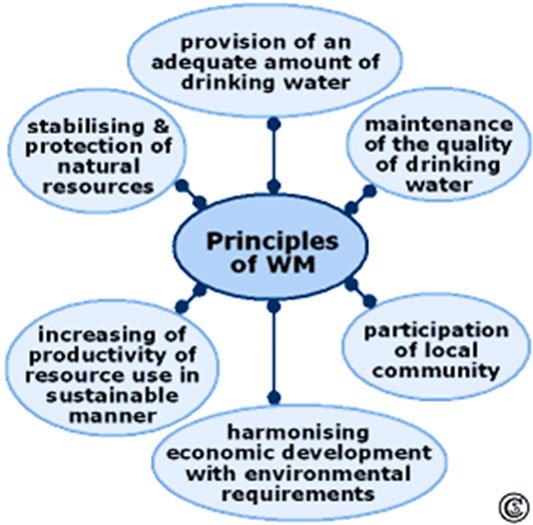
Figure 2.1.2.a. Principles of Watershed Management. Source: after data from Förch and Schütt 2004 b; Heathcote 1998; Panda 2003
These principles can be stated plainly. Sustainable water availability requires that current extraction does not compromise future supplies. Maintenance of water quality means keeping drinking water at standards that safeguard public health. Conservation of natural resources — soil, vegetation, biodiversity — demands minimizing land degradation and controlling erosion. Sustainable utilization insists that land and water productivity improve through practices that are environmentally sound, economically viable, and institutionally supported. Environmentally compatible economic development means promoting livelihoods without destroying the ecological base. Community participation requires that local people are not merely consulted but actively involved in planning, implementation, and decision-making. None of these principles operates in isolation. They are interconnected, and ignoring one undermines the others.
2.1.3 Water Management versus Watershed Management
The distinction between water management and watershed management is not merely semantic. It reflects a fundamental difference in how one conceives of the problem. Water management, as traditionally practiced, concerns the planning, allocation, and regulation of water resources themselves — supply systems, reservoirs, irrigation schedules, wastewater treatment. Its unit of analysis is the water body or infrastructure system. Its central question is: how do we deliver the right quantity and quality of water to the right users? Watershed management asks a prior question: what governs the availability and quality of that water in the first place? It considers the entire drainage basin as the management unit, recognizing that water resources are shaped by land use, vegetation cover, soil conditions, topography, and human activities across the catchment. Erosion control, flood mitigation, habitat restoration, and land-use planning become central concerns — not because they are unrelated to water, but because they are the very processes that determine water outcomes. Water management seeks to optimize use of the resource; watershed management aims to maintain the health and resilience of the system that produces it.
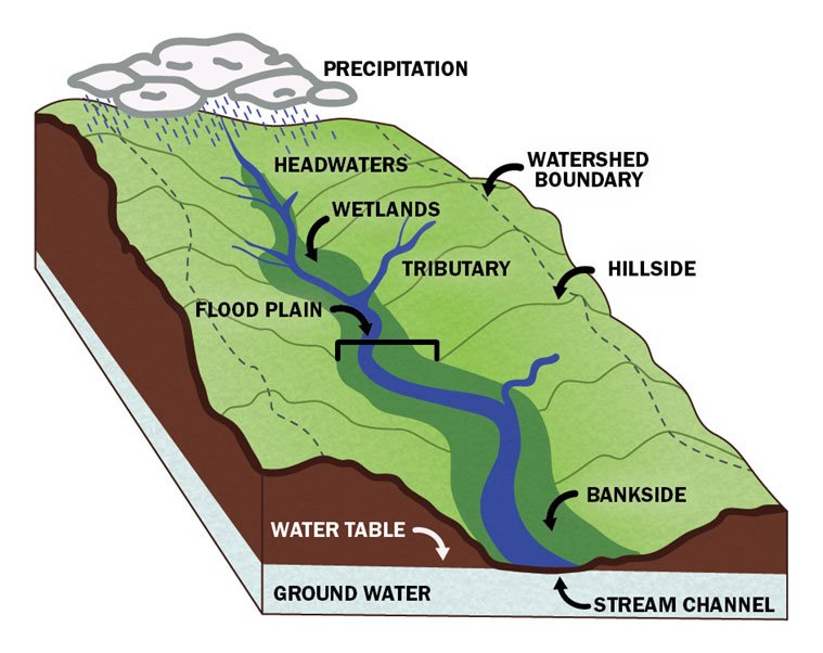
Figure 2.1.3.a. Watershed [Source: Little Conestoga Watershed Alliance © 2026]
Table 2.1.3.a: Comparative analysis between water management and watershed management
| Aspect | Water Management | Watershed Management |
| Primary Focus | Management of water resources | Management of land, water, and ecosystem interactions |
| Management Unit | Water bodies, reservoirs, aquifers, and supply systems | Entire watershed or drainage basin |
| Main Objective | Efficient allocation and utilization of water resources | Sustainable management of watershed resources and ecosystem health |
| Scope | Water quantity and water quality | Water, soil, vegetation, biodiversity, and land use |
| Approach | Resource-centered | Ecosystem-centered and integrated |
| Key Activities | Water supply, storage, distribution, treatment, and conservation | Erosion control, flood management, habitat restoration, land-use planning, and water conservation |
| Major Concerns | Water scarcity, allocation, demand management, and water quality | Watershed degradation, sedimentation, flooding, ecosystem health, and resource sustainability |
| Stakeholders | Water utilities, irrigation agencies, industries, and consumers | Governments, communities, farmers, industries, environmental organizations, and water managers |
| Spatial Scale | Can be local, regional, or sector-specific | Defined by natural watershed boundaries |
| Expected Outcome | Reliable and sustainable water supply | Healthy watershed functions and sustainable water resources |
In summary, Water management focuses on managing water as a resource, whereas watershed management focuses on managing the entire landscape that influences the quantity, quality, and sustainability of that water resource.
A watershed is not only a physical system. It is a social system. People live, work, and make decisions within it, and the consequences of those decisions are shared. Consider an upstream community at the top of a mountain slope. If trees are cleared for fuel, farming, or construction, the short-term benefit is local. The long-term cost is distributed: without tree cover, water runs rapidly downslope, carrying sediment, increasing flood risk, and degrading water quality for everyone below. Farmers lose crops. Homes are damaged. Rivers become turbid. The watershed connects people physically and socially, linking actions to consequences that may be geographically distant but hydrologically immediate. It is often said that watershed management is half science and half people. Scientific knowledge explains rainfall patterns, soil erosion, and hydrological dynamics. Engineering provides solutions — check dams, canals, terraces. But without community cooperation, these solutions rarely endure. People are the daily managers of land and water; their choices determine whether a project succeeds. In Nepal, Water User Associations (WUAs) manage irrigation systems and protect water sources with an understanding of local conditions and traditions that outside experts rarely match. In India, farmers have long managed water through shared rules adapted to their environments. When this knowledge is respected, watershed interventions are more likely to be sustainable. A watershed, then, is not just a physical area defined by water flow. It is a social system shaped by human relationships and responsibilities.
2.1.4 History of Watershed Management
Watershed management did not begin with modern science. Evidence of water conservation and land-water interaction practices appears in ancient civilizations — Mesopotamian irrigation networks, Egyptian nilometers for measuring water levels, and references in the Atharva Veda (c. 1500-500 BCE) to water use regulation. In Nepal, the Newari community's annual Sithi Nakha ceremony — a communal cleaning of water sources — represents a practice of watershed stewardship that predates any formal management framework. These practices cannot be equated with modern watershed management, but they reveal a long-standing awareness that water and land must be managed together. References to water management principles have sometimes been loosely attributed to Benjamin Franklin's 1793 interventions, though structured watershed management as a scientific and institutional approach did not emerge until much later. In the 1970s and 1980s, the field was dominated by an engineering paradigm. Interventions focused on physical structures: check dams, terracing, erosion-control works. Programs were planned top-down, and success was measured in physical outputs — structures built, hectares treated — rather than in long-term ecological or socioeconomic outcomes. By the late 1980s, the limitations of this approach had become difficult to ignore. Many projects failed to achieve sustainability because they paid insufficient attention to local livelihoods, land-use practices, and institutional continuity. This failure prompted a shift toward integrated and participatory approaches linking environmental conservation with agricultural productivity and rural development, setting the foundation for the approaches that expanded in the early 1990s.
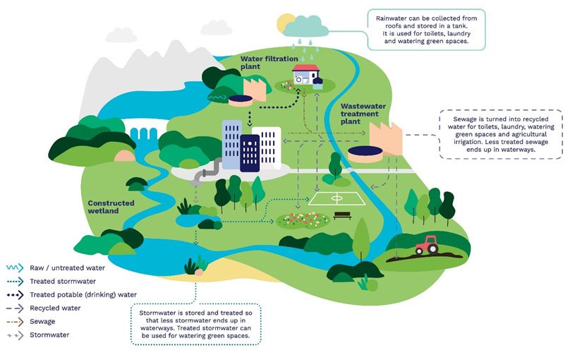
Figure 2.1.4.a. Integrated Water Resource Management Poster. Source: Integrated Water Management Framework, Greater Western Water
The conceptual architecture for this shift was articulated through the Dublin-Rio Principles, adopted at the 1992 Dublin Conference on Water and endorsed at the Rio de Janeiro Summit on Sustainable Development the same year. The Dublin Conference, the most significant global water conference since the 1977 UN Water Conference in Mar del Plata, was convened to prepare the freshwater agenda for the Rio Summit. The Copenhagen Statement, shaped significantly by Danish contributions, influenced the steering committee deliberations and preparatory work. The outcome was four Dublin Principles: freshwater is a finite and vulnerable resource; water development and management should be based on a participatory approach; women play a central role in the provision, management, and safeguarding of water; and water has an economic value in all its competing uses. Three of these drew directly from the Copenhagen framework. Together, they provided the conceptual foundation for the freshwater chapter of Agenda 21 at Rio, formally establishing Integrated Water Resources Management (IWRM) as a global guiding approach.
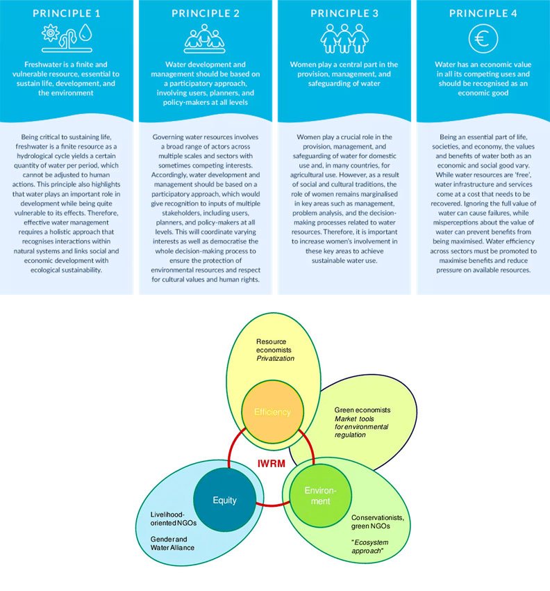
Figure 2.1.4.b. 3Es of the IWRM [Source: Molle, F. (2008). Nirvana concepts, narratives and policy models: Insight from the water sector. Water Alternatives, 1(1): 131‐156]
The Global Water Partnership defines IWRM as "a process which promotes the coordinated development and management of water, land and related resources, in order to maximise economic and social welfare in an equitable manner without compromising the sustainability of vital ecosystems" (Global Water Partnership, 2000). The definition rests on three dimensions: economic efficiency, social equity, and environmental sustainability. In watershed contexts, IWRM seeks to balance upstream and downstream interests, reconcile competing uses — agriculture, urban supply, industry, ecosystems — and build long-term resilience under climate variability.
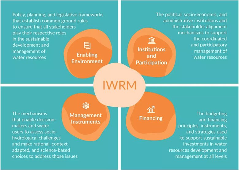
Figure 2.1.4.c. IWRM Principles. Source: Dublin Conference, 1992
The application of IWRM principles requires moving beyond purely technical solutions toward participatory and institutional arrangements that enable coordination across sectors and scales. Biswas (2004) has emphasized that IWRM's success depends not on hydrological knowledge alone but on governance structures, stakeholder engagement, and political commitment. In practice, this is executed through basin organizations, catchment management agencies, or integrated planning frameworks — the Murray-Darling Basin in Australia being a frequently cited example. In larger transboundary basins like the Mekong, IWRM extends into diplomatic coordination among riparian states, adding a layer of political complexity that purely technical frameworks cannot address. This approach aligns with Sustainable Development Goal 6, which focuses on ensuring access to clean water and sanitation for all.
Case Study 2.1-A: Upstream–Downstream Dynamics in the Koshi Basin
Instructions
All students are advised to carefully read the following case study. Upon reading it, your task is to participate in the discussion under Forum W-001. If another participant has already initiated the discussion, contribute your views by responding to the existing thread.
Case Study: Upstream-Downstream Dynamics in the Koshi Basin
The Koshi River, often called the "Sorrow of Bihar," is one of the largest transboundary rivers in the Himalayan region. Originating on the Tibetan Plateau, it is formed by seven major Himalayan tributaries (the Sapta Koshi) that flow through eastern Nepal before entering the plains of northern India and eventually joining the Ganges. The basin covers approximately 87,000 km2, extending across China (Tibet), Nepal, and India, and supports the livelihoods of tens of millions of people through agriculture, fisheries, hydropower, and domestic water supply. The Koshi River is among the most sediment-laden rivers in the world. Every year, enormous quantities of sediment are transported from the rapidly eroding young Himalayan mountains into the plains of Nepal and Bihar. As the river leaves the steep mountain valleys and enters the flat Indo-Gangetic plains, its flow velocity decreases sharply, causing large amounts of sediment to settle within the river channel. Over time, this process raises the riverbed above the surrounding floodplain, increasing the risk of channel shifts and catastrophic flooding. Historical records indicate that the Koshi has migrated more than 100 km across the plains of Bihar over the last two centuries, creating one of the world's largest inland alluvial fans. To reduce flood damage and expand irrigation, Nepal and India signed the Koshi Agreement (1954), which led to the construction of the Koshi Barrage and an extensive system of embankments, completed in the early 1960s. The project was designed to regulate river flows, protect downstream settlements from floods, provide irrigation water to millions of hectares of agricultural land in Bihar, and generate hydropower opportunities. Although the infrastructure has brought substantial agricultural and economic benefits downstream, debates continue regarding the unequal distribution of costs and benefits between upstream and downstream communities. Communities living in the upper watershed of Nepal continue to face severe challenges. Rapid deforestation, expansion of agriculture onto steep slopes, poorly planned road construction, and climate-induced extreme rainfall have accelerated soil erosion and landslide activity. These processes increase sediment delivery into the river system, while many upland communities receive only limited economic benefits from the large-scale water infrastructure located downstream. Many villages also experience declining spring discharge, seasonal water scarcity, and increasing vulnerability to landslides despite being located within one of South Asia's largest river basins.
The downstream consequences became dramatically evident during the 2008 Koshi disaster. On 18 August 2008, the eastern embankment near Kusaha in Nepal breached approximately 13 km upstream of the Koshi Barrage. Instead of remaining within its engineered channel, the river abandoned its course and returned to an older channel that it had not occupied for several decades. The flood inundated large areas of Nepal and northern Bihar, affecting millions of people, destroying homes, cropland, roads, and public infrastructure, and causing one of the most devastating flood disasters in recent South Asian history. The event highlighted not only the enormous sediment dynamics of the Koshi but also institutional shortcomings in embankment maintenance, transboundary coordination, flood forecasting, and emergency response between Nepal and India. Today, the Koshi Basin remains an important example of the complexity of Integrated Water Resources Management (IWRM) in transboundary river systems. Decisions taken in the upstream watershed—such as forest management, road construction, watershed conservation, or reservoir development—directly influence downstream flood hazards, sediment transport, irrigation reliability, and ecosystem health. Likewise, downstream infrastructure and water allocation policies have profound implications for upstream communities, whose participation in decision-making has often been limited. Sustainable management of the Koshi therefore requires cooperation across political boundaries, equitable sharing of benefits and responsibilities, joint monitoring of sediment and flood risks, and long-term watershed restoration that integrates ecological, engineering, and social dimensions.
Questions for Participants (All questions are mandatory):
All participants are requested to read the following questions and post your answers in Forum W-001.
- How would you characterize the equity dimensions of water management in the Koshi basin?
- What institutional mechanisms might address the upstream-downstream asymmetry?
- Where do you see the limits of IWRM as a framework in this context?
Read the Bare Fact
One of the least studied aspects of watershed management is the interaction between surface water and groundwater. Historically managed as separate systems, they are now recognized as hydrologically interconnected. Sophocleous (2002) argues that integrated storage management — coordinating reservoir operations, aquifer recharge strategies, and abstraction policies — can mitigate drought impacts, reduce over-extraction, and maintain environmental flows. The water-balance equation accounts for infiltration, yet this component is frequently neglected in practical watershed management, creating systematic imbalances. Making this "invisible resource visible" is more necessary now than ever.
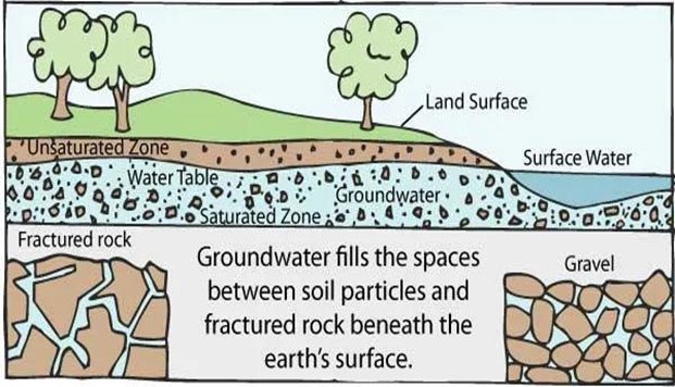
Figure 2.1.4.d. Schematic diagram of groundwater. Source: The U.S. Geological Survey
Groundwater constitutes roughly 99 percent of all liquid freshwater on Earth. Approximately 50 percent of the global population depends on it for drinking water, and it accounts for 43 percent of irrigation withdrawals. Seventy percent of global groundwater withdrawals are for agriculture. Of the world's 37 largest aquifers, 21 are being depleted faster than they can recharge. Despite these figures, groundwater remains largely invisible in policy and practice. Unlike rivers and lakes, it cannot be seen until a well is drilled. This invisibility has allowed over-pumping to become a persistent, often unaddressed problem, particularly in South Asia and the Middle East. In many regions, extraction rates — especially for irrigation — far exceed natural recharge. The result is falling water tables, dry wells, and worsening drought vulnerability. The consequences of unchecked extraction are not abstract. Mexico City, sitting atop the ancient lakebed of Lake Texcoco — composed of deep, water-saturated clay and sediments — has extracted groundwater for decades at rates far exceeding recharge. As reported in a June 2026 CNN article, the city is sinking so rapidly that the subsidence is visible from space. The aquifers can no longer keep pace with pumping, and the physical collapse of the clay matrix beneath the city is essentially irreversible.
Task and Instructions for Students
Watch the following short documentary on Mexico City's water crisis. Consider how the principles of watershed management discussed so far apply, or fail to apply, to this case. Post a short reflection (200-300 words) in the forum identifying which principle of watershed management, if enforced earlier, might have prevented or mitigated the current crisis.
(Copyright: Video creators retain copyright. Links are to open-access educational content.)
Managed Aquifer Recharge (MAR) offers a corrective approach. Rather than allowing rainwater and flood runoff to discharge into rivers and seas, MAR captures water and enhances its infiltration into aquifers during high-rainfall periods. Think of it as refilling the hidden tank beneath us. Sources can be diverse: treated wastewater, stormwater, surface water from rivers or canals.
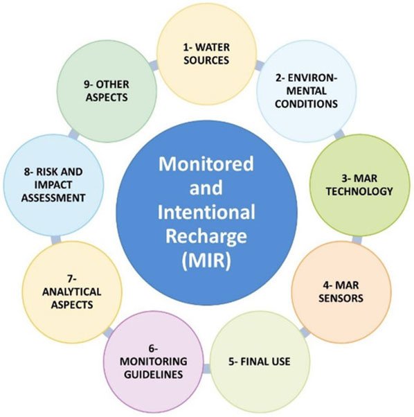
Figure 2.1.4.e. Components of the monitored and intentional recharge (MIR) conceptual model and proposed chapters (called blocks) for any managed aquifer recharge (MAR) system´s technical guidelines document.
Techniques include recharge ponds and percolation tanks — shallow basins holding surface water for seepage — recharge wells that move water directly below ground, and rainwater harvesting systems that channel collected water into the subsurface. A global inventory of MAR schemes, compiled from over 50 countries encompassing around 1,200 case studies, constitutes the first worldwide record of such interventions.
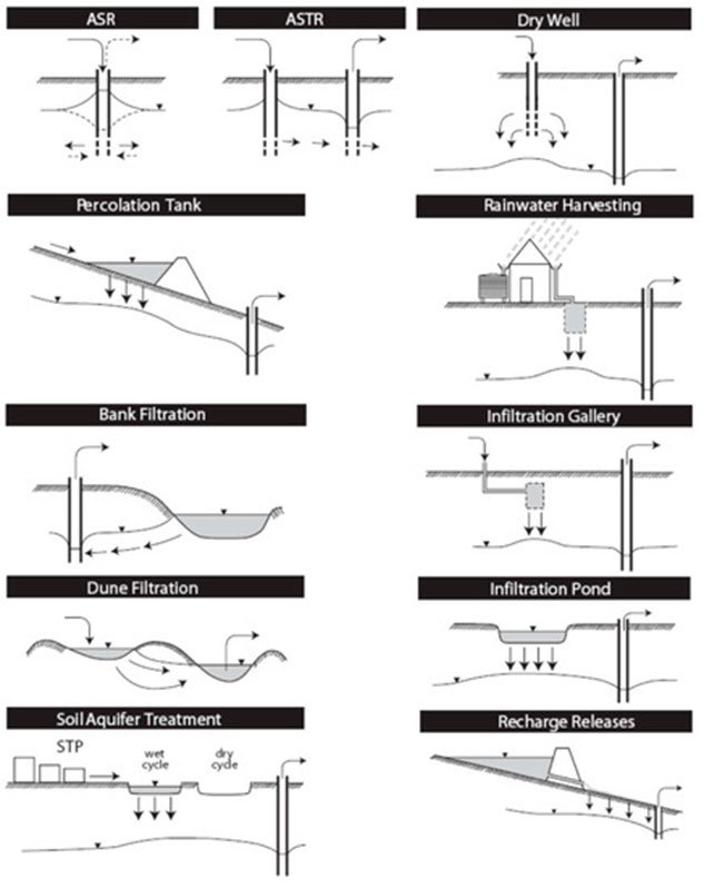
Figure 2.1.4.f. Schematic of types of MAR suited to urban water management (modified from: Dillon, 2005). ASR-Aquifer Storage and Recovery; ASTR-Aquifer Storage Transfer Recovery; STP-Sewerage Treatment Plant.
In India's Ganga-Yamuna Doab region, government mapping has identified over 150 potential MAR sites. A 2025 study on the Ramganga basin demonstrated that MAR interventions added measurable water to the aquifer, though currently accounting for only 2.5-7.5 percent of natural rainfall recharge. The research suggests that substantial expansion — potentially tens of thousands of recharge ponds — would be needed to meaningfully offset long-term groundwater decline.
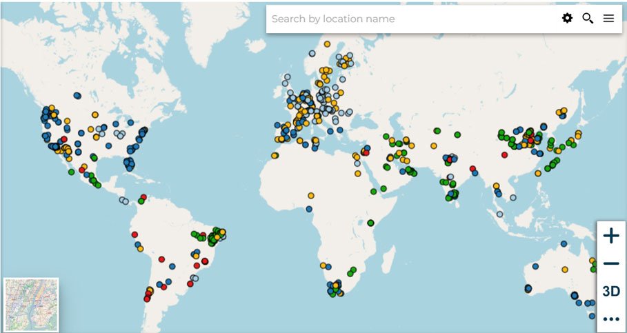
Figure 2.1.4.g. The Inventory locations of reported Global MAR sites. Source: UN-IGRAC
Site selection remains a critical challenge. Geophysical techniques, particularly Electrical Resistivity Tomography (ERT), function as a subsurface imaging tool, revealing where geology is porous and water-conductive versus dense and impermeable. Recent research in the Barakar River Basin showed that combining ERT surveys with advanced modelling and machine learning improved assessments of aquifer recharge potential, aiding decisions about where to concentrate efforts. Yet for MAR and related tools to succeed, they must be paired with local participation, policy commitment, and long-term investment.
2.1.5. Water Economics
Water is not only a component of Earth's natural systems. It is an economic resource supporting agriculture, industry, energy production, and domestic consumption. Its availability, distribution, and management directly influence economic growth and human well-being. As demand rises and supply becomes more uncertain, the relationship between water and economic activity demands analytical attention.
The economic value of water arises from its scarcity and its role in producing goods and services. Agriculture depends on reliable irrigation. Industry requires water for manufacturing, cooling, and processing. Water infrastructure — dams, reservoirs, treatment plants — represents substantial investment. Yet water scarcity, pollution, and unequal access create economic costs that are frequently unaccounted for. Water resource economics, as articulated by Rogers et al. (1998), studies how water is allocated, used, valued, and managed, considering both the costs of provision and the benefits derived from use. The field brings together hydrology, engineering, policy, and economics to address a central question: how can society use water efficiently, equitably, and sustainably?
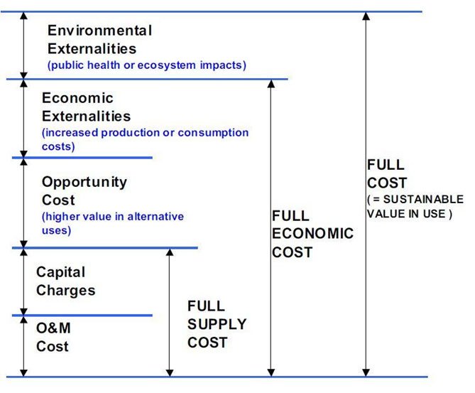
Figure 2.1.5.a. General principle for full cost of water [Credit: Savenije & van der Zaag (2002)]
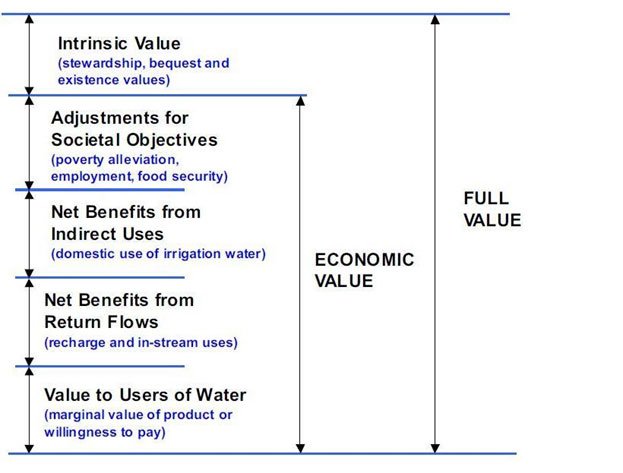
Figure 2.1.5.b. General principle for full value of water. [Credit: Savenije & van der Zaag (2002)]
A comprehensive economic evaluation requires accounting for direct costs — infrastructure, operation, maintenance — and indirect costs related to environmental impacts and resource depletion. At the same time, water generates value through its various uses, influenced by reliability, availability, and quality. From a sustainability perspective, effective management seeks balance between the full costs of provision and the value obtained from use. Economic methods in water resource economics are often deductive, providing the ability to evaluate and make predictions of future hypothetical conditions — for instance, estimating future costs and benefits to support project evaluation or alternative policy reforms through ex ante analysis.
The Tragedy of the Commons, articulated by Garrett Hardin in 1968, describes a situation where individuals acting in their self-interest collectively overuse and deplete a shared resource. In water economics, this pattern is repeatedly observed in groundwater aquifers, rivers, and communal irrigation systems. Individual users receive the immediate benefits of extraction while the environmental and social costs are distributed among all. The result: declining water tables, reduced streamflow, deteriorating quality, and escalating competition. Groundwater depletion in heavily irrigated regions — the North China Plain, the Ogallala Aquifer in the United States, the Indo-Gangetic basin — exemplifies this dynamic. Preventing it requires institutions and governance mechanisms: water rights, abstraction regulations, economic incentives, community-based management, and monitoring systems.
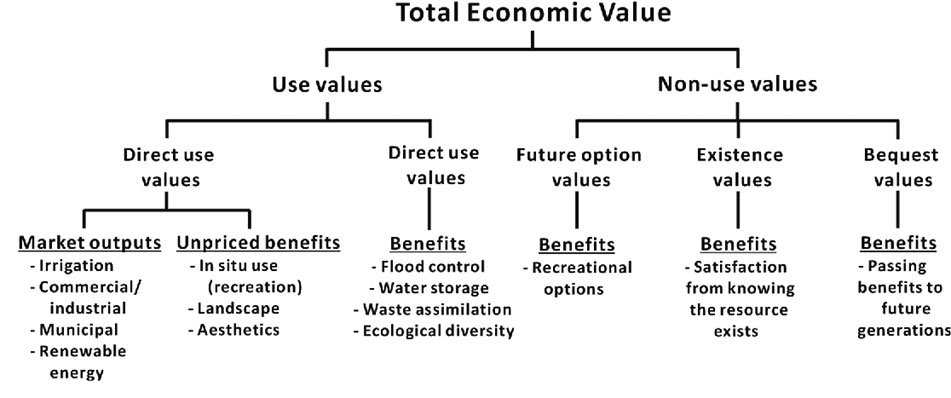
Figure 2.1.5.c. Schematic diagram of the Total Economic Value (TEV) method (after Marcouiller and Coggins, 1999).
The Total Economic Value (TEV) framework captures both use and non-use values of water. A unit of water used for drinking in a city may generate higher social benefits than the same unit applied to low-value crops in a water-scarce region. Recognizing such differences helps prioritize allocation during shortages. Tietenberg and Lewis (2018) argue that economic valuation makes explicit the opportunity costs of water use, enabling comparison between alternatives. Pricing mechanisms — volumetric tariffs, groundwater pumping fees — can encourage conservation when designed carefully, though poorly designed pricing can penalize the poor. Equity considerations complicate the economics considerably. Water is simultaneously an economic good and a human right. Poor households, small farmers, and marginalized communities are typically the most vulnerable to scarcity and rising prices. Lifeline tariffs for basic needs, targeted subsidies, and community-based management aim to reconcile efficiency with social justice, though the tension between these objectives persists in practice.
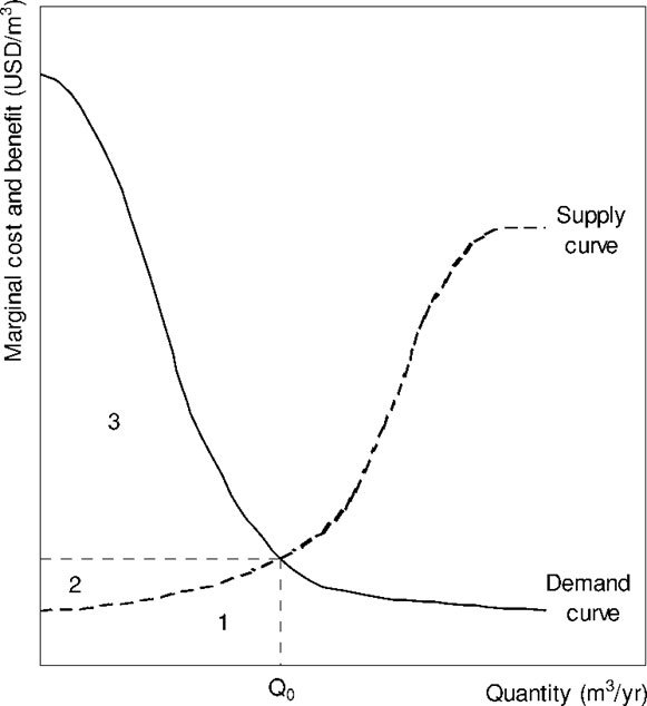
Figure 2.1.5.d. Supply and demand curve for water. Source: Hubert H.G. Savenije
The supply-demand framework for water, as presented by Savenije and elaborated by Hoekstra et al. (2001), shows that the marginal benefit of water generally decreases with increasing quantity — willingness to pay for the first units exceeds willingness to pay for the last. Marginal cost of supply typically increases with quantity due to growing scarcity, though it does not continue to increase indefinitely; once costs reach a level where importing desalinated water becomes more attractive than extracting the last drop of local water, the curve flattens. According to Vidal-Lamolla et al. (2024), factors shifting the demand curve independently of price include population changes, income levels, climate and seasonality, and the adoption of conservation technologies such as low-flow fixtures and water-saving appliances. Water resource economics also plays a critical role in infrastructure and investment decisions. Building dams, reservoirs, desalination plants, or Managed Aquifer Recharge systems requires large upfront costs. Economic analysis helps compare these options by weighing costs against long-term benefits, risks, and environmental impacts. In many cases, demand management — conservation and reuse — may prove more cost-effective than expanding supply. Rivers, wetlands, and aquifers provide ecosystem services such as flood control, water purification, and habitat support. When these services are ignored, short-term economic gains can lead to long-term losses — groundwater depletion, land subsidence, ecosystem collapse. Closely linked to economic reasoning is the practice of water budgeting — a quantitative accounting of all inflows, outflows, and changes in storage within a defined system. In a watershed, inflows include precipitation and upstream contributions; outflows consist of evapotranspiration, surface runoff, groundwater discharge, and human abstractions. The fundamental equation — inputs minus outputs equal change in storage — allows planners to assess availability, identify deficits, and evaluate sustainability. Dingman (2015) describes water budgeting as an essential diagnostic tool informing both short-term operations and long-term planning under climate change. It acts as a strict accounting framework relying on the conservation of mass within a defined geographic control volume.
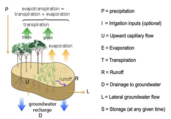
Figure 2.1.5.e.: Schematic 1D vertical Water balance at the landscape scale. Source: Aquaticecodynamics github
The water-budget equation is simple, universal, and adaptable because it relies on few assumptions about the mechanisms of water movement and storage. A basic form for a small watershed can be expressed as:
Where P is precipitation — all forms of water condensing from atmospheric vapor and falling to Earth's surface, including rain, drizzle, snow, sleet, graupel, and hail. As the primary freshwater source, precipitation sustains ecosystems, agriculture, industry, and human societies, though its global distribution is highly uneven. Beyond supplying freshwater, precipitation drives the continuous redistribution of energy within the Earth system, thereby influencing weather patterns and environmental conditions. Changes in land use, agriculture, urbanization, and water infrastructure alter runoff, infiltration, evaporation, and storage patterns, making water budgets valuable for assessing the impacts of both climate variability and human interventions. Through the transformation of water among its liquid, solid, and gaseous states, precipitation contributes to the redistribution of energy within the Earth system, thereby influencing weather patterns, climate processes, and the functioning of natural and human environments worldwide. (Source: NASA Goddard Space Flight Center). QIN is the water flow into the watershed, which is the total runoff entering the water body/hydrologic region/watershed, measured in units of height or volume per unit time. This includes all forms of precipitation, including liquid (rain, drizzle, cloudburst, storm) or freezing/mixed (freezing drizzle, freezing rain, rain and snow mixed) or frozen (snow, hail, ice) and the upstream contributing sources like glaciers, rivulets, and springs. ET is evapotranspiration (the sum of evaporation from soils, surface-water bodies, and plants), measured in units of height or units of volume/units of time.
Mandatory Quiz: [Click Here]
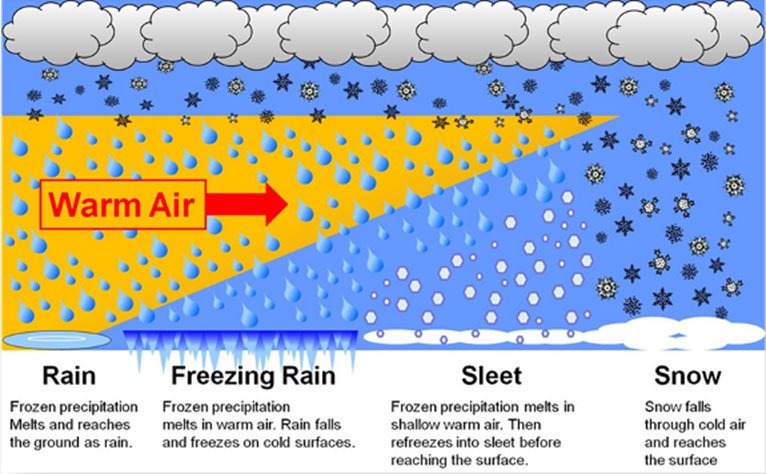
Figure 2.1.5.f: Typical types of Precipitation. Source: NOAA, 2013
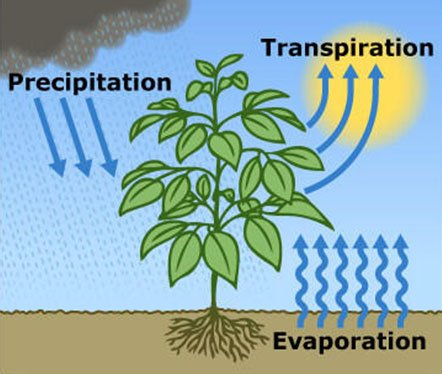
Figure 2.1.5.g: Schematic diagram of Evapotranspiration
Plants absorb water through their roots and release it as vapor through stomata — a process called transpiration. Combined with direct evaporation from soil and wet plant surfaces, this constitutes evapotranspiration (ET). ET represents the principal pathway through which a vegetated landscape consumes water and serves as the foundational metric for determining irrigation requirements. Total landscape water demand also includes losses through deep percolation and runoff, but in most watersheds, ET dominates the water budget. ΔS denotes the change in water storage. A positive value indicates net accumulation within the watershed; a negative value signals depletion. When inputs equal outputs, ΔS approaches zero, representing a steady-state condition — rarely sustained for long in natural systems but useful as a theoretical baseline. Qout is the total outflow from the watershed, primarily surface runoff, measured over the same temporal and spatial scales as the other budget components.
Task for Students: Elinor Ostrom and the Commons
The Tragedy of the Commons, as discussed earlier, paints a pessimistic picture of shared resource management. Yet it is not the only theoretical lens available. Valuable works in this context include those of political economist Elinor Ostrom, particularly her book “Governing the Commons: The Evolution of Institutions for Collective Action” (1990), for which she received the Nobel Prize in Economic Sciences. Read the following note and post your reflections in Forum W-001 addressing the following:
- Does Ostrom's empirical evidence fundamentally challenge Hardin's tragedy, or does it simply identify the narrow conditions under which the tragedy can be averted?
- Which of Ostrom's eight design principles do you consider most difficult to achieve in practice in watershed management?
Elinor Ostrom and Community-Based Management of Common Resources
For many years, the dominant explanation for the degradation of shared natural resources was Garrett Hardin's influential essay The Tragedy of the Commons (1968). Hardin argued that when a resource is freely accessible to everyone, each individual has an incentive to maximize personal benefit while sharing the costs of overuse with the entire community. According to this reasoning, common resources such as forests, fisheries, grazing lands, and irrigation water inevitably become degraded unless they are either privatized or placed under strict government control. Political economist Elinor Ostrom challenged this assumption through decades of empirical research on communities around the world. Rather than relying on theoretical models alone, she examined how farmers, fishers, and local communities successfully managed shared resources over long periods without privatization or centralized control. Her work culminated in the landmark book Governing the Commons: The Evolution of Institutions for Collective Action (1990), for which she was awarded the 2009 Nobel Prize in Economic Sciences. Ostrom argued that the "tragedy" is not inevitable. She demonstrated that communities can sustainably manage common-pool resources when appropriate institutions are developed collectively by resource users. Through numerous case studies—including irrigation systems in Nepal and Spain, communal forests in Japan, and groundwater management in California—she identified common characteristics shared by successful community-managed systems. Ostrom proposed eight design principles that frequently occur in successful commons management: (1) clearly defined resource boundaries and user groups; (2) rules that match local environmental and social conditions; (3) participation of resource users in developing and modifying rules; (4) effective monitoring by accountable individuals; (5) graduated sanctions for rule violations; (6) accessible mechanisms for resolving conflicts; (7) recognition of community rights by external authorities; and (8) coordination among institutions when managing larger resource systems. Rather than replacing government entirely, Ostrom emphasized polycentric governance, where local communities, governments, and other institutions share responsibility according to their strengths. Local users often possess detailed ecological knowledge and have strong incentives to protect resources that directly support their livelihoods, while governments provide legal support, technical expertise, and coordination across larger scales. Watershed management provides an excellent example of Ostrom's ideas in practice. Many successful watershed programmes depend not only on engineering structures such as check dams or terraces, but also on collective agreements regarding grazing, tree cutting, water allocation, and maintenance. Community institutions such as Water User Associations and watershed committees help ensure that rules are followed and benefits are shared fairly. Projects such as Sukhomajri (India) demonstrate that long-term success depends as much on social institutions as on technical interventions. Ostrom did not argue that every commons will succeed. Instead, she showed that successful collective management depends on appropriate institutional arrangements, trust among users, effective monitoring, and participation in decision-making. Where these conditions are absent, common resources may indeed experience the type of degradation described by Hardin.
2.1.6. Economic Tools in Watershed Management
Economic appraisal tools provide the structure for comparing alternative watershed interventions — soil conservation, afforestation, flood control, ecosystem restoration — when resources are limited and trade-offs are inevitable. Cost-Benefit Analysis (CBA) remains the most widely adopted technique. At its core, CBA uses discounted cash flow analysis to compare the present value of a project's benefits against its costs over time. If benefits exceed costs, the project is considered economically justified. In watershed contexts, this approach proves particularly useful because interventions like reforestation or Managed Aquifer Recharge incur high upfront costs but generate benefits — improved water supply reliability, reduced flood damage, enhanced groundwater recharge — over decades. Boardman et al. (2018) note that modern CBA in water projects extends beyond direct financial returns to include ecosystem services and social welfare. Recently, in May 2026, the New South Wales Government Department of Climate Change, Energy, the Environment and Water (DCCEEW) released guidelines explicitly adapting CBA for water conservation, signaling its continued dominance in public sector decision-making. Not all watershed values, however, lend themselves easily to monetization. Ecosystems provide benefits — biodiversity, recreation, microclimate regulation — that lack traditional market prices. Non-market valuation tools, particularly Willingness to Pay (WTP) surveys, attempt to estimate the societal value of these services by asking households how much they would financially support the protection of local waterways (Gunawardena et al., 2020). Feuilette et al. (2016) applied such approaches during the implementation of the Water Framework Directive in France. Yet WTP is sensitive to survey design, income levels, and cultural contexts, making its application in diverse watershed settings analytically fraught.
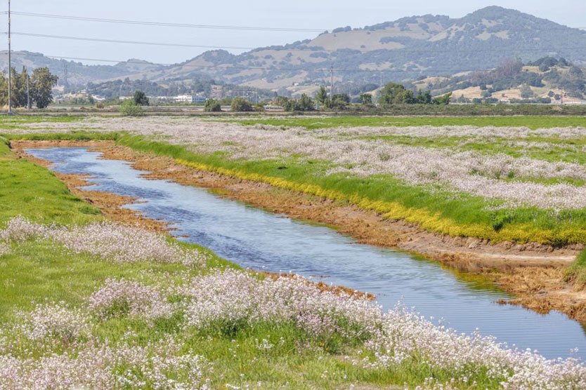
Figure 2.1.6.a. Aboveground vegetation around a river. Source: Pexels (Open access)
When monetary metrics are insufficient, or when decision-makers face conflicting objectives that resist reduction to a single currency, Multi-Criteria Decision Analysis (MCDM) offers an alternative. MCDM scores options against multiple, weighted criteria — cost, ecological impact, political feasibility, cultural heritage — allowing for a more transparent evaluation of trade-offs than pure economic efficiency (Taherdoost, 2023). Hydro-economic modeling pushes this integration further by embedding hydrological data directly within economic frameworks. Expósito et al. (2020) highlight that these coupled models evaluate water allocation and policy interventions under climate uncertainty, increasingly incorporating the water-energy-food nexus. Despite their sophistication, none of these tools yield unambiguous answers. A defining challenge of applying CBA in watershed management is the issue of distributional effects. Benefits and costs are rarely shared evenly across a catchment. Upstream afforestation might impose costs on upland farmers through reduced agricultural land, while generating flood-control benefits downstream. If these uneven impacts are not explicitly recognized — and where appropriate, compensated — even economically "efficient" projects can fail due to social resistance. Economic tools are decision-support mechanisms, not decision rules. Integrating them with participatory planning and hydrological analysis leads to more legitimate outcomes than relying on any single metric in isolation.
Task for students
Before moving to water modeling, watch this short documentary to ground the economic and management concepts discussed above in lived reality.
Video: "World's Water Crisis"
2.1.7. Water Modeling
Water modeling employs mathematical, statistical, and computational frameworks to represent and predict hydrological behavior. As water systems grow more stressed by population growth, land-use change, and climate variability, models have shifted from academic exercises to central components of planning and policy analysis. The fundamental rationale for modeling is straightforward: hydrological processes vary across space and time in ways that direct observation cannot fully capture. Models provide a simplified but scientifically structured representation, allowing managers to test scenarios, manage risk, and optimize resource allocation without exposing real systems to harm. Modern watershed management relies on two broad modeling paradigms, often used in combination: simulation and optimization. Simulation models, such as the Soil and Water Assessment Tool (SWAT), replicate the physical behavior of hydrological systems. They simulate precipitation, evapotranspiration, surface runoff, infiltration, groundwater flow, and sediment transport based on inputs like land use, soil characteristics, topography, and climate data. Their primary strength lies in scenario analysis — exploring how a watershed might respond to deforestation, agricultural expansion, or climate shifts. They function, in effect, as virtual laboratories for diagnosing environmental problems before committing resources to physical interventions.
Optimization models serve a different purpose. Rather than describing how a system behaves, they prescribe how it should be managed to achieve specific objectives — maximizing water supply reliability, minimizing costs, or reducing flood risk — subject to physical, economic, and institutional constraints. Using linear, nonlinear, or dynamic programming, these models allocate water among competing users and schedule infrastructure operations. Loucks and van Beek (2017) argue that the most robust decision-support systems emerge when simulation and optimization are integrated. A simulation model like SWAT might generate outputs on runoff and recharge, which then serve as constraints in an optimization model determining the most cost-effective placement of conservation measures. This coupling links system understanding with decision efficiency. It is worth noting, however, that models carry inherent limitations. They are only as reliable as their input data and structural assumptions. In data-scarce regions — which include many of the world's most water-stressed watersheds — model outputs must be treated with considerable caution. Furthermore, models do not replace judgment, institutional knowledge, or stakeholder engagement. They provide a transparent, structured framework to inform these processes, but the decisions themselves remain irreducibly political and social.
Additional Watch
Watch this video on "SDG 6: Integrated Water Resources Management" by UN Water
Wrap Up the Unit 2.1
In summary, the principles of water management in watersheds rest on integration across disciplines, resources, and stakeholders. IWRM provides the conceptual framework, while economics, water budgeting, modeling, and cost-benefit analysis supply the analytical tools. None of these tools is sufficient alone, and all carry limitations that practitioners must navigate carefully. Together, however, they enable informed, equitable, and sustainable management of water resources at the watershed scale.
Group Online Discussion
Enter Forum W-001 to participate in the group discussion threads:
- Identify a specific aquifer system where this dynamic is playing out and discuss what institutional failures are driving it.
- Under what hydrological and socioeconomic conditions is MAR most likely to succeed?
References
Alam, M.F., et al. (2025), Assessing the contribution of managed aquifer recharge programs on
groundwater storage in the Ramganga basin https://doi.org/10.1016/j.gsd.2025.101486
Biswas, A. K. (2004). Integrated Water Resources Management: A Reassessment. Water
International, 29(2), 248-256. https://doi.org/10.1080/02508060408691775
Boardman, A. E., Greenberg, D. H., Vining, A. R., & Weimer, D. L. (2018). Cost-Benefit Analysis:
Concepts and Practice (5th ed.). Cambridge University Press. https://doi.org/10.1017/9781108235594
Copenhagen Statement (1991/1992), DANIDA, Ministry of Foreign Affairs
https://www.ircwash.org/sites/default/files/210-92CO-9217.pdf
Dingman, S. L. (2015). Physical Hydrology (3rd ed.). Waveland Press.
Dingman, S. L. (2022). Physical Hydrology (3rd ed.). Waveland Press.
https://www.waveland.com/browse.php?t=384
Dino Ratnaweera; Arve Heistad; Ståle Navrud , 2021, The current use and potential of cost benefit
analysis in water sector projects, Water Supply (2021) 21 (4): 1438–1449. https://doi.org/10.2166/ws.2020.364
Expósito, A., Beier, F., Berbel, J., & Arsenopoulos, A. (2020). Hydro-economic modelling for water-
policy assessment under climate change at a river basin scale: A review. Water, 12(6), 1559. https://doi.org/10.3390/w12061559
Feuillette, S., Levrel, H., Boeuf, B., et al. (2016). The use of cost-benefit analysis in environmental
policy: Insights from the implementation of the European Water Framework Directive in France. Environmental Science & Policy, 57, 79-89. https://doi.org/10.1016/j.envsci.2015.12.002
Global Water Partnership. (2000). Integrated Water Resources Management (TAC Background
Papers No. 4). Stockholm, Sweden. https://www.gwp.org/globalassets/global/toolbox/publications/background-papers/04-integrated-water-resources-management-2000-english.pdf
Groundwater for Sustainable Development, Article 101486.
https://doi.org/10.1016/j.gsd.2025.101486
Gunawardena, A., et al. (2020). Non-market valuation approaches for environmental and water
resource management. Australasian Journal of Water Resources, 24(1), 1-15. https://doi.org/10.1080/13241583.2020.1746174
Hardin, G. (1968). The Tragedy of the Commons. Science, 162(3859), 1243-1248.
https://doi.org/10.1126/science.162.3859.1243
Healy, R. W., Winter, T. C., LaBaugh, J. W., & Franke, O. L. (2007). Water Budgets: Foundations
for Effective Water Resources and Environmental Management. U.S. Geological Survey Circular 1308. https://doi.org/10.3133/cir1308
Heathcote, I. W. (1998). Integrated Watershed Management: Principles and Practice. Wiley.
International Conference on Water and the Environment (ICWE). (1992). The Dublin Statement on
Water and Sustainable Development. Dublin, Ireland. https://www.wmo.int/pages/prog/hwrp/documents/english/icwedece.html
Loucks, D. P., & van Beek, E. (2017). Water Resource Systems Planning and Management: An
Introduction to Methods, Models, and Applications. Springer. https://doi.org/10.1007/978-3-319-44234-1
Marcouiller, D. W., & Coggins, J. S. (1999). The Economic Value of Ecosystem Services. University
of Wisconsin Extension Publication.
Panda, S. C. (2003). Planning and Management of Watersheds. Agrobios. (Book)
Rogers, P., de Silva, R., & Bhatia, R. (1998). Water as a Social and Economic Good: How to Put the
Principle into Practice. Global Water Partnership Technical Advisory Committee Background Paper No. 2.https://www.gwp.org/globalassets/global/toolbox/publications/background-papers/02-water-as-a-social-and-economic-good-1998-english.pdf
Savenije, H. H. G., & van der Zaag, P. (2002). Water as an Economic Good and Demand
Management: Paradigms with Pitfalls. Water International, 27(1), 98-104. https://doi.org/10.1080/02508060208686982
Sophocleous, M. (2002). Interactions Between Groundwater and Surface Water: The State of the
Science. Hydrogeology Journal, 10, 52-67. https://doi.org/10.1007/s10040-001-0170-8
Taherdoost, H. (2023). Multi-Criteria Decision Making Methods and Concepts. Encyclopedia, 3(1),
77-87. https://doi.org/10.3390/encyclopedia3010006
Tietenberg, T., & Lewis, L. (2018). Environmental and Natural Resource Economics (11th ed.).
Routledge. https://doi.org/10.4324/9781315229270
UNCED Rio Earth Summit (1992), United Nations. (1992). Agenda 21: Programme of Action for
Sustainable Development. United Nations Conference on Environment and Development, Rio de Janeiro. https://sustainabledevelopment.un.org/content/documents/Agenda21.pdf
United Nations Educational, Scientific and Cultural Organization (UNESCO). (2022). United Nations
World Water Development Report 2022: Groundwater - Making the Invisible Visible. UNESCO. https://unesdoc.unesco.org/ark:/48223/pf0000380721
Vidal-Llamola, P., et al. (2024). Drivers of Urban Water Demand under Climate and Socioeconomic
Change. Sustainable Cities and Society, 105, 105435. https://doi.org/10.1016/j.scs.2024.105435