Unit 2.6: Watershed Management and Climate Change
Instructor: Ms. Syeda Tabassum Tasfia
2.6.1: Climate Variability and Climate Change
One of the central distinctions in climate science, and one that is frequently conflated in public discussion and environmental management, is the difference between climate variability and climate change. Climate variability refers to fluctuations in climatic conditions relative to longer-term averages over seasonal, interannual, or decadal timescales. These fluctuations are associated with naturally occurring modes of atmosphere–ocean interaction such as the El Niño–Southern Oscillation (ENSO), the Pacific Decadal Oscillation (PDO), the Atlantic Multidecadal Oscillation (AMO), and the Indian Ocean Dipole (IOD). Such processes influence rainfall, temperature, drought frequency, and flood occurrence in many regions of the world and can substantially affect watershed hydrology.
Climate change, in contrast, refers to long-term changes in the statistical properties of the climate system, including shifts in mean conditions and changes in the frequency or intensity of extremes. The IPCC (2021) concluded that human influence has unequivocally warmed the atmosphere, ocean, and land. The IPCC Sixth Assessment Report estimated that global surface temperature during 2011–2020 was approximately 1.09°C higher than the 1850–1900 baseline (IPCC, 2021). Anthropogenic greenhouse gas emissions are therefore altering the climatic conditions within which natural variability occurs, increasing the likelihood and severity of some hydro-climatic extremes.
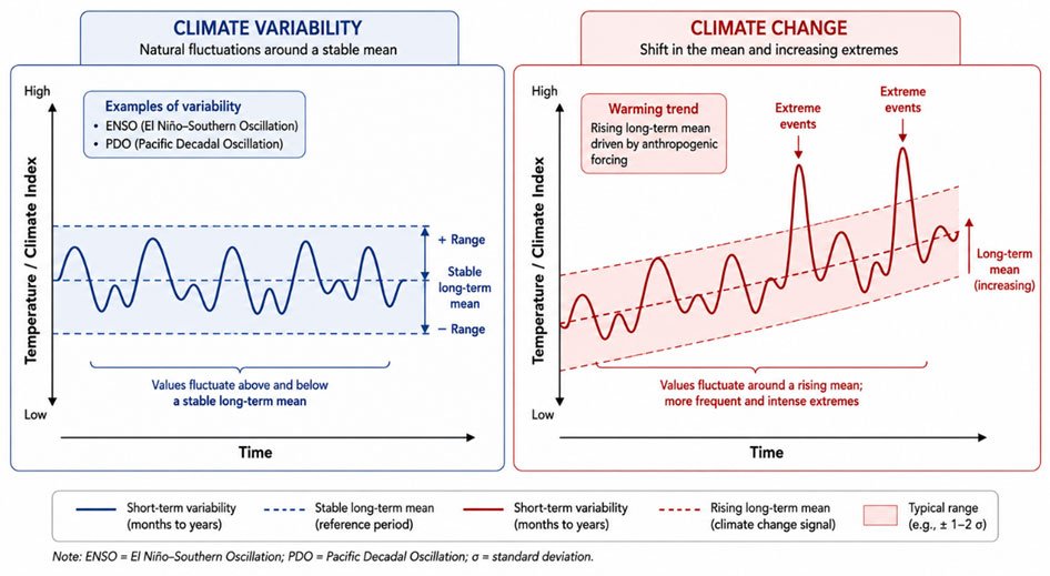
Figure 2.6.1a: Schematic representation of climate variability (left panel) and long-term climate change (right panel). Climate variability refers to natural oscillations of temperature or climate index values around a stable long-term mean, as illustrated by oscillating cycles with a fixed ± range. Examples include the El Niño–Southern Oscillation (ENSO) and Pacific Decadal Oscillation (PDO). Climate change, in contrast, involves a shift in the long-term mean driven by anthropogenic forcing, so that the same short-term oscillations now occur around a rising baseline, with more frequent and intense extreme events (shown as elevated spikes above the rising mean). The pink shaded band represents the typical range (±1–2 standard deviations). Arrows indicate warming trend direction. (Image courtesy: Original schematic by Syeda Tabassum Tasfia. Conceptual representation informed by IPCC AR6 WG1 (2021).)
For watershed management, distinguishing between variability and long-term change is important because the reliability of historical hydrological records depends on whether climatic conditions remain statistically stable through time. Traditional water resources planning has often assumed stationarity, meaning that historical patterns of streamflow, precipitation, and flood frequency are representative of future conditions. Milly et al. (2008) argued that this assumption is increasingly unreliable under contemporary climate change because hydrological systems are being altered by long-term warming and associated changes in the water cycle. Although historical records remain valuable, watershed planning increasingly requires approaches that account for uncertainty, non-stationarity, and changing climate risks.
Observed and Projected Climate Trends
The IPCC Sixth Assessment Report documents widespread changes in the global water cycle that are relevant to watershed systems. Observations indicate that heavy precipitation events have intensified in many regions, the atmosphere’s moisture-holding capacity has increased with warming, and changes in evapotranspiration are altering hydrological balances (IPCC, 2021). The Clausius–Clapeyron relationship indicates that atmospheric water-holding capacity increases by approximately 7% per degree Celsius of warming, contributing to the potential for more intense rainfall events. Regional responses, however, vary considerably. Some high-latitude and tropical regions have experienced increases in precipitation, whereas drying trends have been documented in several subtropical regions, including parts of the Mediterranean, southern Africa, and southwestern North America (IPCC, 2021). Consequently, climate impacts on watershed hydrology are spatially heterogeneous and depend on regional atmospheric circulation, land cover, topography, and water use practices.
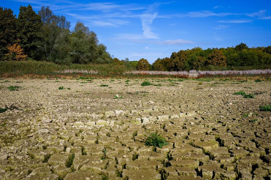
Figure 2.6.1b: Drought-stricken riverbed illustrating climate-driven shifts in watershed hydrology and the growing variability of water availability. (Image courtesy: Nikola Tomašić, https://unsplash.com )
Cryospheric change has major implications for mountain watersheds. Glacier retreat, reductions in snowpack, and earlier snowmelt have altered streamflow timing in many snow- and glacier-fed river systems. In some regions, glacier melt may temporarily increase river discharge before long-term declines occur as glacier volume decreases, a process often referred to as “peak water.” Such changes are particularly important for downstream water supply, hydropower generation, and irrigation in regions including the Himalaya, Andes, and Alps (IPCC, 2021). Groundwater systems are also affected by climate variability and climate change. Changes in precipitation seasonality, evapotranspiration, and recharge influence groundwater availability, especially in shallow and unconfined aquifers. In some semi-arid regions, reduced recharge and increasing groundwater extraction are contributing to declining groundwater levels. However, groundwater responses are often highly localised and influenced by geology, land use, and water management practices.
Task for Students
Identify a river basin or watershed in your country or region and investigate whether significant changes in rainfall, streamflow, snowpack, or groundwater levels have been documented during recent decades. Based on available evidence, discuss whether the observed changes are more likely associated with climate variability, long-term climate change, or a combination of both. Identify the sources of data and methods used in your analysis. Post your findings in Forum W-001.
References
Intergovernmental Panel on Climate Change. (2021). Climate change 2021: The physical science
basis. Cambridge University Press. https://www.ipcc.ch/report/ar6/wg1/
Intergovernmental Panel on Climate Change. (2022). Climate change 2022: Impacts, adaptation
and vulnerability. Cambridge University Press. https://www.ipcc.ch/report/ar6/wg2/
Milly, P. C. D., Betancourt, J., Falkenmark, M., Hirsch, R. M., Kundzewicz, Z. W., Lettenmaier,
D. P., & Stouffer, R. J. (2008). Stationarity is dead: Whither water management? Science, 319(5863), 573–574. https://doi.org/10.1126/science.1151915
2.6.2: Changing Hydro-Climatic Patterns
Climate change influences watershed hydrology through changes in temperature, precipitation, evapotranspiration, and the timing and intensity of hydro-climatic events. Warming increases the atmosphere’s moisture-holding capacity, which can contribute to the intensification of heavy precipitation events in many regions (IPCC, 2021). At the same time, changes in circulation patterns and land–atmosphere interactions may alter the seasonal distribution and variability of rainfall. Temperature increases affect hydrological systems through multiple pathways. Higher temperatures generally increase potential evapotranspiration, which can intensify soil moisture deficits and increase drought stress even where annual precipitation remains relatively stable. Consequently, hydrological and agricultural drought conditions may intensify independently of changes in total rainfall.
Distinguishing between different forms of drought is therefore important. Meteorological drought refers primarily to precipitation deficits, hydrological drought involves reduced streamflow, reservoir levels, or groundwater availability, and agricultural drought refers to insufficient soil moisture for crop growth. These drought types may occur simultaneously, but they can also develop at different timescales depending on watershed characteristics and water management practices.
Climate change also affects vegetation and ecosystem processes that influence hydrology. Changes in temperature and moisture availability can alter evapotranspiration rates, vegetation cover, wildfire occurrence, and erosion processes. In some forested regions, prolonged drought and heat stress have been associated with increased tree mortality and wildfire risk, which may subsequently influence runoff generation, sediment transport, and water quality.
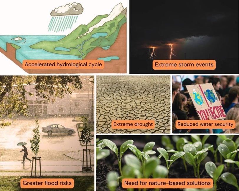
Figure 2.6.2.a: The impacts of an accelerated hydrological cycle under climate change, from extreme storms and flooding, to drought and reduced water security, alongside nature-based solution approaches for adaptation. (Image courtesy: Stormwater Management Journalhttps://ucanr.edu/sites/default/files/styles/ex/public/2025-07/WSS%20%234%20Blog%20Cover.png.webp?itok=4dzgIH5i
Implications for Watershed Hydrology
Hydrological responses to climate change vary among watershed types. In snowmelt-dominated basins, warmer temperatures have contributed to earlier snowmelt and shifts in seasonal runoff timing in several regions. In rainfall-dominated systems, increases in rainfall intensity may contribute to flash flooding, while longer dry intervals may reduce baseflow and water availability during dry seasons. Groundwater recharge dynamics may also change under altered precipitation regimes. In some environments, intense rainfall events may enhance recharge where infiltration pathways are available, whereas in other settings, increased runoff and evaporation may reduce effective recharge. The relationship between climate change and groundwater recharge therefore, depends on soil characteristics, geology, vegetation, and rainfall timing.
Task for Students
Using publicly available climate projection tools such as the IPCC Interactive Atlas or the World Bank Climate Change Knowledge Portal, identify projected temperature and precipitation changes for your watershed region under two emissions scenarios (for example, SSP1-2.6 and SSP5-8.5) during the period 2050–2100. Discuss the range of projections, associated uncertainties, and likely implications for watershed hydrology. Post your findings in Forum W-001.
References
Intergovernmental Panel on Climate Change. (2021). Climate change 2021: The physical science
basis. Cambridge University Press. https://www.ipcc.ch/report/ar6/wg1/
Intergovernmental Panel on Climate Change. (2022). Climate change 2022: Impacts, adaptation
and vulnerability. Cambridge University Press. https://www.ipcc.ch/report/ar6/wg2/
Schewe, J., Heinke, J., Gerten, D., Haddeland, I., Arnell, N. W., Clark, D. B., & Gosling, S. N.
(2014). Multimodel assessment of water scarcity under climate change. Proceedings of the National Academy of Sciences, 111(9), 3245–3250. https://doi.org/10.1073/pnas.1222460110
2.6.3: Climate-Induced Risks and Extremes
Floods, Droughts, Landslides, and Extreme Events
Climate-related hazards such as floods, droughts, landslides, and wildfires can significantly alter watershed processes and increase risks to ecosystems and human communities. Flood generation is influenced by rainfall intensity and duration, antecedent soil moisture, land cover, drainage density, and watershed geomorphology. Climate change has increased the intensity of heavy precipitation events in many regions, although flood responses vary depending on local hydrological and land use conditions (IPCC, 2021). Urbanisation can further increase flood risk by expanding impervious surfaces and reducing infiltration. In many cities, drainage infrastructure designed using historical rainfall statistics may be less effective under changing rainfall patterns.
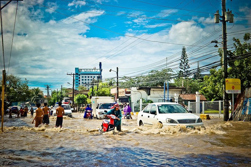
Figure 2.6.3. a: Urban flooding during extreme rainfall. (Image Courtesy: j_lloahttps://pixabay.com/)
Droughts develop over longer timescales and may affect soil moisture, streamflow, groundwater, ecosystems, and agriculture. Increased evaporative demand associated with warming can intensify drought impacts even in regions where precipitation trends are uncertain. Groundwater droughts may persist for years because aquifer recovery can occur slowly. Landslides and debris flows are often associated with intense rainfall, steep slopes, vegetation loss, and soil instability. Deforestation, wildfire, and land degradation can reduce slope stability and increase susceptibility to rainfall-triggered mass movement events.
Geomorphic and Hydrological Responses to Extreme Events
Extreme hydro-climatic events can produce long-term geomorphic and ecological changes within watersheds. Large floods may mobilise substantial sediment from hillslopes and river channels, altering channel morphology, reservoir storage, and aquatic habitats. Sediment pulses generated during major events may continue to influence downstream systems for years. Wildfire can also significantly alter watershed hydrology. Severe fires may reduce vegetation cover, modify soil structure, and in some cases contribute to the development of hydrophobic soil conditions that reduce infiltration and increase runoff. Post-fire watersheds are therefore often vulnerable to flash floods, debris flows, and elevated sediment transport during subsequent rainfall events. The 2010 Pakistan Floods: Climate Extremes and Watershed Vulnerability
The 2010 Pakistan floods were associated with exceptionally intense monsoon rainfall and affected large areas of the Indus River basin. Research suggests that both meteorological conditions and pre-existing watershed vulnerabilities, including land degradation, floodplain encroachment, and deforestation in some upland areas, contributed to the severity of impacts. The event illustrates how climatic extremes and watershed vulnerability can interact to increase disaster risk.
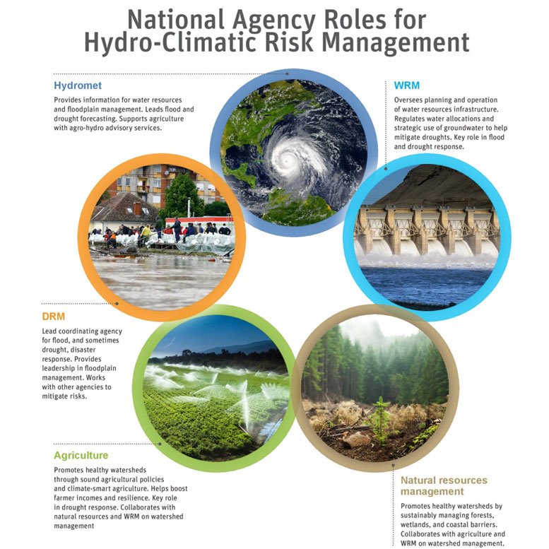
Figure 2.6.3. b: Schematic of national agency roles for hydro-climatic risk management across floods, agriculture, infrastructure, and natural resources, illustrating the multi-sectoral institutional challenge of managing climate-induced watershed risks. (Image courtesy: World Bankhttps://www.worldbank.org/content/dam/photos/768x768/2021/may/EPIC-RESPONSE-square-agency.jpg)
Task for Students
Select a major flood, drought, wildfire, or landslide event from the past 15 years. Analyse the event using a watershed perspective. Discuss the climatological triggers, watershed characteristics, and management factors that may have amplified or reduced vulnerability. Propose watershed-scale interventions that might reduce future risk. Post your findings in Forum W-001.
Watch the following video: Forested Watershed Climate Strategies and Approaches.
Courtesy: Northern Institute of Applied Climate Science
References
Intergovernmental Panel on Climate Change. (2021). Climate change 2021: The physical science
basis. Cambridge University Press. https://www.ipcc.ch/report/ar6/wg1/
Intergovernmental Panel on Climate Change. (2022). Climate change 2022: Impacts, adaptation
and vulnerability. Cambridge University Press. https://www.ipcc.ch/report/ar6/wg2/
Merz, B., Kreibich, H., Schwarze, R., & Thieken, A. (2010). Assessment of economic flood
damage. Natural Hazards and Earth System Sciences, 10(8), 1697–1724. https://doi.org/10.5194/nhess-10-1697-2010
Syvitski, J. P. M., Vörösmarty, C. J., Kettner, A. J., & Green, P. (2005). Impact of humans on the
flux of terrestrial sediment to the global coastal ocean. Science, 308(5720), 376–380. https://doi.org/10.1126/science.1109454
2.6.4: Watershed Degradation and Environmental Problems
Land Degradation, Sedimentation, and Groundwater Depletion
Watershed degradation commonly results from the cumulative interaction of land use change, soil erosion, vegetation removal, pollution, hydrological alteration, and unsustainable water extraction. A healthy watershed generally retains the capacity to regulate runoff, support ecological processes, maintain water quality, and sustain groundwater recharge. Degraded watersheds often exhibit reduced infiltration, increased erosion, declining water quality, and altered hydrological regimes.
Watershed degradation commonly results from the cumulative interaction of land use change, soil erosion, vegetation removal, pollution, hydrological alteration, and unsustainable water extraction. A healthy watershed generally retains the capacity to regulate runoff, support ecological processes, maintain water quality, and sustain groundwater recharge. Degraded watersheds often exhibit reduced infiltration, increased erosion, declining water quality, and altered hydrological regimes.
Sedimentation is a major environmental and engineering challenge in many river basins. Excess sediment delivery can increase turbidity, degrade aquatic habitats, clog irrigation infrastructure, and reduce reservoir storage capacity. Reservoir sedimentation rates vary considerably among regions and catchments, depending on erosion intensity, geology, and watershed management practices.
Groundwater depletion results primarily from excessive extraction relative to recharge. Satellite observations from the Gravity Recovery and Climate Experiment (GRACE) mission have identified significant terrestrial water storage declines, including groundwater depletion signals, in several heavily irrigated regions. Reduced recharge associated with land use change and climate variability may further contribute to groundwater stress.
Watch the following video:
The video highlights urban water crisis and groundwater depletion: challenges for sustainable water security and resilience. Courtesy: The Sunita Narain Show| Down To Earth.
Diffuse (Non-Point Source) Pollution and Ecosystem Degradation
Diffuse, or non-point source, pollution refers to contamination originating from multiple dispersed activities and landscape processes rather than from a discrete discharge location. In agricultural settings, it commonly includes nutrients, pesticides, sediments, and pathogens transported by surface runoff and subsurface flow; in urban environments, stormwater runoff can convey hydrocarbons, heavy metals, nutrients, sediments, and increasingly recognized contaminants such as microplastics and other human-derived particles (U.S. Environmental Protection Agency [EPA], 2015; Amato-Lourenço et al., 2024; Ledesma et al., 2021). As rainfall moves across fields, roads, and settlements, it mobilises these pollutants and delivers them to streams, wetlands, lakes, and coastal waters, often exhibiting elevated transport during storm events and, in some systems, seasonal hydrological peaks (EPA, 2015; Amato-Lourenço et al., 2024). Because pollutant loading is cumulative and event-driven, ecological responses are frequently better understood at sub-catchment and basin scales, where the effects of dispersed land use become apparent across larger spatial extents (Allan, 2004; Meyer et al., 2005). Managing diffuse pollution is therefore challenging because sources are spatially dispersed, temporally variable, and closely tied to routine land-use and economic activity. Effective watershed management must integrate land-use planning, riparian buffers, soil and water conservation, and green infrastructure for stormwater control, alongside community engagement and source reduction measures (National Research Council [NRC], 2002). Wetlands and floodplains are especially important because they can temporarily retain, transform, and store sediments and nutrients before they reach downstream waters, although their effectiveness depends on landscape position, hydrologic connectivity, and loading intensity (Craft & Casey, 2000; Noe & Hupp, 2005; NRC, 2002). In this sense, watershed-scale analysis is often more appropriate than parcel-scale analysis for understanding cumulative impacts and planning restoration interventions (Allan, 2004; NRC, 2002).
Feedback Loops in Degraded Watersheds
Feedback mechanisms can accelerate watershed degradation and make recovery progressively more difficult. For example, vegetation loss increases runoff and erosion, which can reduce soil fertility and inhibit revegetation, creating a self-reinforcing cycle of land degradation (Lal, 2001). Sedimentation and channel instability can reduce floodplain connectivity and simplify channel morphology, processes that are often associated with declines in habitat complexity and ecological recovery potential (NRC, 2002; Wohl, 2004). In coastal regions, excessive groundwater extraction can contribute to saltwater intrusion and, in some coastal settings, land subsidence (Werner et al., 2013; Werner & Simmons, 2009).
Salinisation may reduce agricultural productivity and vegetation cover, and under some conditions it can alter evapotranspiration and local water balances, reinforcing hydrological stress (Qadir et al., 2014). Taken together, these reinforcing processes can push watersheds toward persistent degraded states characterised by self-reinforcing ecological and geomorphic change, so restoration becomes substantially more difficult and costly once thresholds are crossed (Walker et al., 2004). Recognising this feedback underscores the importance of preventive watershed management and early intervention, especially through vegetation protection, groundwater regulation, and conservation of wetlands and riparian zones (NRC, 2002).
Task for Students
Identify a watershed in your region experiencing land degradation, sedimentation, groundwater depletion, or non-point source pollution. Describe the evidence for degradation and discuss the feedback mechanisms involved. Suggest interventions that could reduce or reverse degradation trends. Post your findings in Forum W-001.
References
Allan, J. D. (2004). Landscapes and riverscapes: The influence of land use on stream
ecosystems. Annual Review of Ecology, Evolution, and Systematics, 35, 257–284. https://doi.org/10.1146/annurev.ecolsys.35.120202.110122
Craft, C., & Casey, W. P. (2000). Sediment and nutrient accumulation in floodplain and
depressional freshwater wetlands of Georgia, USA. Ecological Applications, 10(2), 526–536. https://doi.org/10.1890/1051-0761(2000)010%5B0526:SANAIF%5D2.0.CO;2
Intergovernmental Panel on Climate Change. (2022). Climate change 2022: Impacts, adaptation and
vulnerability. Cambridge University Press. https://www.ipcc.ch/report/ar6/wg2/
Lal, R. (2001). Soil degradation by erosion. Land Degradation & Development, 12(6), 519–539.
https://doi.org/10.1002/ldr.472
Ledesma, S., et al. (2021). Urban stormwater runoff: A major pathway for anthropogenic
particles, black rubbery fragments, and other types of microplastics to urban receiving waters. ACS ES&T Water, 1(3), 564–575. https://doi.org/10.1021/acsestwater.1c00017
Meyer, J. L., Paul, M. J., & Taulbee, W. K. (2005). Stream ecosystem function in urbanizing
landscapes. Journal of the North American Benthological Society, 24(3), 602–612. https://doi.org/10.1899/0887-3593(2005)024%5B0602:SEFIUL%5D2.0.CO;2
National Research Council. (2002). Riparian areas: Functions and strategies for management.
National Academies Press. https://doi.org/10.17226/10327
Qadir, M., Quillérou, E., Nangia, V., Murtaza, G., Singh, M., Thomas, R. J., Drechsel, P., &
Noble, A. D. (2014). Economics of salt-induced land degradation and restoration. Natural Resources Forum, 38(4), 282–295. https://doi.org/10.1111/1477-8947.12054
U.S. Environmental Protection Agency. (2015). Basic information about nonpoint source (NPS)
pollution https://www.epa.gov/nps/basic-information-about-nonpoint-source-nps-pollution
U.S. Environmental Protection Agency. (n.d.). Basic information about nonpoint source (NPS)
pollution. Retrieved May 23, 2026, from https://www.epa.gov/nps/basic-information-about-nonpoint-source-nps-pollution
Walker, B., Holling, C. S., Carpenter, S. R., & Kinzig, A. (2004). Resilience, adaptability and transformability in
social–ecological systems. Ecology and Society, 9(2), 5. https://www.ecologyandsociety.org/vol9/iss2/art5/
Werner, A. D., Bakker, M., Post, V. E. A., Vandenbohede, A., Lu, C., Ataie-Ashtiani, B., Simmons, C. T., & Barry,
D. A. (2013). Seawater intrusion processes, investigation and management: Recent advances and future challenges. Advances in Water Resources, 51, 3–26. https://doi.org/10.1016/j.advwatres.2012.03.004
Werner, A. D., & Simmons, C. T. (2009). Impact of sea-level rise on sea water intrusion in coastal
aquifers. Ground Water, 47(2), 197–204. https://doi.org/10.1111/j.1745-6584.2008.00535.x
Wohl, E. (2004). Disrupted lands: River channel morphology and the sediment regime. Progress in Physical
Geography, 28(2), 126–147. https://doi.org/10.1191/0309133304pp404ra
2.6.5: Watershed Vulnerability Assessment and Adaptation Strategies
Concepts and Frameworks for Watershed Vulnerability Assessment
Climate vulnerability assessment provides a framework for understanding how watersheds may be affected by climate-related hazards. The IPCC has described vulnerability in terms of exposure, sensitivity, and adaptive capacity (IPCC, 2007). Exposure refers to the degree to which a watershed experiences climatic stressors such as droughts, floods, or temperature change. Sensitivity describes how strongly ecological, hydrological, and social systems respond to those stressors. Adaptive capacity refers to the ability of institutions, communities, and ecosystems to adjust to changing conditions.
Watershed vulnerability assessments commonly involve baseline characterization of watershed conditions, evaluation of climate exposure, identification of sensitive systems or populations, and assessment of institutional and technical capacity for adaptation. Spatial tools, climate projections, hydrological models, and indicator-based methods are often used to support these assessments. Indicator-based vulnerability indices can assist practitioners in identifying areas of relatively high or low vulnerability, particularly where detailed modelling capacity is limited. However, such indices simplify complex socio-ecological systems and should therefore be interpreted cautiously. Scenario-based approaches that consider multiple climate futures are increasingly recommended because they better reflect uncertainty in future climatic conditions. Rather than relying on a single prediction, adaptive watershed planning often emphasizes flexibility, resilience, and iterative decision-making.
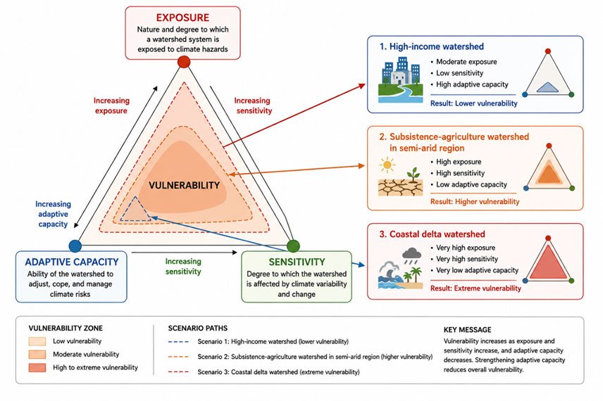
Figure 2.6.3.b: The IPCC AR4 (2007) vulnerability framework applied to watershed systems, illustrating how combinations of exposure (the degree to which a watershed is exposed to climate hazards), sensitivity (the degree to which the system is affected by climate variability and change), and adaptive capacity (the ability to adjust, cope, and manage climate risks) determine overall vulnerability. The nested shading zones indicate low (outer), moderate (middle), and high to extreme (inner) vulnerability. Three illustrative watershed scenarios are shown: (1) a high-income watershed with moderate exposure, low sensitivity, and high adaptive capacity, resulting in lower vulnerability; (2) a subsistence-agriculture watershed in a semi-arid region with high exposure and sensitivity and low adaptive capacity, resulting in higher vulnerability; and (3) a coastal delta watershed with very high exposure and sensitivity and very low adaptive capacity, resulting in extreme vulnerability. Mini-triangles (right) show the relative vulnerability position of each scenario. (Image courtesy: Original schematic by Syeda Tabassum Tasfia). Conceptual vulnerability framework informed by IPCC AR4 (2007).)
Adaptation Strategies for Climate-Resilient Watersheds
Adaptation strategies in watershed management may include structural, ecological, institutional, and behavioural measures. Supply-side measures can involve improved water storage, groundwater recharge, and infrastructure upgrades. Demand-side measures may include water-use efficiency, irrigation improvements, and conservation practices. Nature-based solutions and ecosystem-based adaptation approaches have received increasing attention because they may provide multiple benefits for water regulation, biodiversity, and climate resilience. Examples include reforestation, wetland restoration, riparian buffer establishment, floodplain reconnection, and green urban infrastructure. Evidence suggests that nature-based solutions can contribute to flood mitigation, erosion control, water quality improvement, and biodiversity conservation, although effectiveness varies among contexts and scales (Chausson et al., 2020). Adaptation planning should also consider the possibility of maladaptation. Measures that reduce short-term risks may unintentionally increase long-term vulnerability. For example, extensive flood-control infrastructure may encourage settlement in high-risk floodplains, while intensive groundwater extraction used for drought adaptation may accelerate aquifer depletion. Adaptive management approaches that include monitoring, stakeholder participation, and periodic reassessment are therefore important components of climate-resilient watershed planning.
Watch the following video: which shows integrated watershed adaptation through ecosystem restoration, infrastructure improvements, and stakeholder participation.
Task for Students
Develop a watershed adaptation strategy for a watershed experiencing climate-related stress. Identify key vulnerabilities using the exposure–sensitivity–adaptive capacity framework. Propose nature-based, engineered, and institutional adaptation measures. Discuss at least one potential maladaptation risk and explain how it could be minimized. Outline a monitoring strategy to support adaptive management. Post your findings in Forum W-001.
Mandatory Quiz: [Click Here]
References
California Department of Water Resources. (2023). Watershed resilience framework and toolkit.
Canadian Council of Ministers of the Environment. (n.d.). Tools for climate change vulnerability
assessments for watersheds. https://ccme.ca/en/res/pn1494_vat-secure.pdf
Chausson, A., Turner, B., Seddon, D., Chabaneix, N., Girardin, C. A. J., Key, I., Smith, A.,
Woroniecki, S., & Seddon, N. (2020). Mapping the effectiveness of nature-based solutions for climate change adaptation. Global Change Biology, 26(11), 6134–6155. https://doi.org/10.1111/gcb.15310
Intergovernmental Panel on Climate Change. (2007). Climate change 2007: Impacts, adaptation
and vulnerability. Cambridge University Press.
Intergovernmental Panel on Climate Change. (2022). Climate change 2022: Impacts, adaptation
and vulnerability. Cambridge University Press. https://www.ipcc.ch/report/ar6/wg2/
International Institute for Sustainable Development. (2017). Adaptive watershed training:
Watershed-based adaptation and management. https://www.iisd.org/projects/adaptive-watershed/
U.S. Environmental Protection Agency. (2025). Developing a watershed vulnerability index.
https://www.epa.gov/hwp/developing-watershed-vulnerability-index
weADAPT. (2023). Watershed vulnerability and adaptation assessments.
https://weadapt.org/knowledge-base/vulnerability/guidelines-for-climate-change-practitioners/s
Unlock the secrets of water resource management with our groundbreaking online course.
Partner Organization

Collaborating Organizations