Unit 1.6: Irrigation Water And Technologies
Instructor: Mr. Kartik Omanakuttan
In this Unit 1.6, we examine irrigation, the largest human intervention in the global water cycle, as both a technical system and a governance regime. Irrigation has made possible the feeding of billions of people in regions where rainfall alone cannot sustain agriculture. It has also driven the depletion of aquifers, the salinisation of soils, the collapse of river systems, the spread of waterborne disease, and the unequal redistribution of water from ecological and subsistence uses to commercial agriculture.
The unit situates irrigation within agronomy, hydrology, political economy, public health, and ecological science. It challenges the common framing of irrigation as simply a technical solution to water scarcity, asking instead: who governs irrigation? Who benefits from it, at what cost to whom, and what institutional arrangements perpetuate damage even when better options are known?
1.6.1 The Scale, History and Stakes of Global Irrigation
What is Irrigation and Why Does It Matter?
Irrigation is the deliberate application of water to land to support crop production, supplementing or replacing natural rainfall. It is one of humanity's oldest technologies — irrigation agriculture appeared in Mesopotamia, the Nile Valley, the Indus Valley, and China more than five thousand years ago, enabling the emergence of settled, complex societies in regions where rain-fed agriculture was unreliable.
Today, irrigated agriculture occupies approximately 20% of cultivated land globally but produces roughly 40% of the world's food output (FAO, 2021). This productivity advantage — the result of reliable water supply allowing more intensive cropping, higher-yielding varieties and year-round production — makes irrigation central to global food security, particularly in Asia, the Middle East and North Africa, where large populations live in water-limited environments.
Globally, irrigation accounts for approximately 70% of total freshwater withdrawals from rivers, lakes, and aquifers, making it the dominant driver of water abstraction worldwide (Gleick & Cooley, 2021). In many river basins, the consumptive use of water by irrigation, water that evaporates or is taken up by crops and does not return to the source, reduces flows to levels insufficient to sustain downstream ecosystems, riparian communities, and coastal fisheries. Irrigation is thus simultaneously the foundation of food security and the single largest pressure on freshwater systems on Earth.
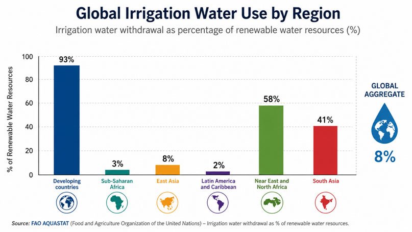
Figure 1.6.1: Global irrigation water use by region — a proportional bar or pie chart showing the share of freshwater withdrawals attributed to irrigation in major world regions, with a global aggregate. Source: FAO AQUASTAT (2022).
Understanding irrigation requires holding two things simultaneously: its genuine, documented contribution to human food security and rural livelihoods on one hand, and its equally genuine, documented ecological and social costs on the other. The governance challenge is not to choose between food production and water stewardship, but to design the institutional frameworks that allow both to be pursued without irreversibly sacrificing one for the other.
Task and Instructions for Students
Participants are advised to engage with the following open-access materials illustrating irrigation expansion, water diversion, and efficiency debates.
Essential Watch
Overview of irrigation patterns and water withdrawals.
Additional Watch
Analysis of irrigation efficiency, rebound effects, and sustainability trade-offs.
While watching, note how irrigation expansion and water scarcity are discussed. Is water scarcity presented as a natural condition or as a governance problem?
While watching, consider: Under what governance conditions would efficiency gains actually reduce total water use, rather than enabling expansion?
Narration: Irrigation as Engine of Productivity and Depletion
Historically, pre-industrial irrigation was governed through community institutions — the acequia associations of Spain and the American Southwest, the subak systems of Bali, the karez networks of Central Asia and Iran, the tank irrigation systems of South India — that managed shared water resources through customary rules, collective maintenance obligations, and conflict resolution mechanisms developed over generations. These systems were imperfect and sometimes inequitable, but many were genuinely sustainable, matching extraction to available supply and distributing water according to socially negotiated agreements. The twentieth century introduced a fundamentally different scale and logic of irrigation. Large-scale state-built canal systems — the great dam projects of the mid-century era in India, Pakistan, Egypt, the United States, and the Soviet Union — were designed to transform landscapes and economies through centralised water management. Motorised pumps and subsidised energy simultaneously enabled the decentralised explosion of groundwater irrigation across South Asia and China. Together, these developments drove a global irrigation expansion that roughly tripled irrigated area between 1950 and 2000.
The food production gains were real and significant. But so were the unintended consequences. The Aral Sea — fed by the Amu Darya and Syr Darya rivers, both of which were diverted in growing volumes to cotton and wheat irrigation from the 1960s onward — illustrates with terrible clarity what can happen when irrigation is governed as a production problem rather than a basin management problem. The rivers were progressively drained into canals. The sea shrank. The fishery collapsed. A new desert formed. We will examine this case in detail below. Today, irrigation expansion increasingly relies on groundwater, whose extraction is less visible and less governed than surface water diversions. In large parts of South Asia, the Middle East, North Africa, and the American West, irrigation is drawing on groundwater reserves accumulated over geological timescales, at rates that cannot be sustained. As Unit 1.5 examined in the context of the Ogallala Aquifer, this is a trajectory toward a depletion crisis that will arrive within decades in the most overexploited systems.
Reflective Questions (Mandatory)
Post your reflections in Forum W-001 under the tag "Reflective Questions 1.6".
- Why has irrigation expansion historically been prioritized over water conservation?
- Can irrigation efficiency gains reduce total water use, or do they encourage expansion?
- Who benefits most from irrigation subsidies and technological upgrades?
1.6.2 Salinization, Waterlogging and Disease in Irrigated Landscapes
Soil Degradation: Salinization and Waterlogging
Poorly managed irrigation progressively degrades the soils it is designed to make productive. Two related processes — waterlogging and salinization — affect an estimated 10% of irrigated land globally, causing annual crop losses exceeding US$27 billion (FAO, 2021). Waterlogging occurs when irrigation raises the water table to within the root zone of crops, saturating the soil and excluding the oxygen that plant roots require. It results from over-irrigation (more water applied than soils can absorb), poor drainage design, or the leakage of water from unlined canals that recharges local groundwater. Waterlogged soils are anaerobic, structurally damaged, and unproductive. Salinization occurs when the naturally occurring salts in irrigation water — even in water of apparently good quality, all water contains trace salts — accumulate in the root zone as water evaporates and is taken up by crops. Without adequate drainage to flush salts below the root zone, concentrations build season by season. As salinity increases, osmotic stress prevents plants from drawing water from the soil even when the soil is wet; the plant effectively desiccates in moist ground. Yields of sensitive crops such as maize, beans, and leafy vegetables fall first; more tolerant crops such as barley and cotton can persist at higher salinity, but eventually all production becomes impossible. In severely salinised areas, yields of staple crops can decline by up to 70% (Shrivastava and Kumar, 2015), reducing food security and rural incomes precisely in regions that have invested most in irrigation infrastructure. The geography of salinization aligns closely with the geography of irrigation — the dry climates where irrigation is most needed are also the climates where evaporative concentration of salts is fastest and where natural rainfall is insufficient to flush accumulated salts from the root zone. The Indus basin of Pakistan, the Tigris-Euphrates basin of Iraq, the Murray-Darling basin of Australia, and the valley floors of the American West are all areas where salinization has already removed large areas from productive use, and where the trajectory of continued irrigation without improved drainage is toward further degradation.
Disease Ecology: Irrigation and Public Health
Irrigation reshapes landscape hydrology in ways that create breeding habitats for disease vectors, modify microclimates, and alter the conditions for pathogen survival and transmission. The public health consequences are well documented but rarely integrated into irrigation planning and assessment. Malaria is the disease most consistently linked with irrigation. Anopheles mosquitoes, the vectors of Plasmodium parasites that cause malaria, breed in slow-moving, warm, shallow water: exactly the conditions created by unlined irrigation canals, poorly drained fields, blocked drainage channels, and irrigation-fed wetlands. Studies in sub-Saharan Africa, South Asia, and Southeast Asia consistently find higher malaria incidence in irrigated than in non-irrigated communities, often dramatically so. Kibret et al. (2014) documented malaria incidence rates up to six times higher in irrigated villages than in nearby non-irrigated communities in Ethiopia.
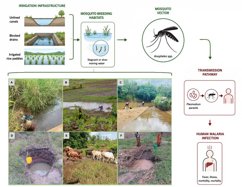
Figure 1.6.2: Disease ecology in irrigated landscapes — diagram showing how irrigation infrastructure creates potential mosquito breeding habitats (A washing dishes beside river streams, B cleaning dishes within flooded rice fields, C laundering clothes by riverbanks, D fetching drinking water from dug pits, E providing water for livestock at river streams, and F collecting water from dug pits for household use) and the transmission pathway from breeding water to human malaria infection (Adopted from Kahamba et al., 2024).
Schistosomiasis (bilharzia) — a parasitic infection with severe long-term health consequences affecting over 200 million people globally — is strongly linked with slow-moving freshwater habitats that support the intermediate host snails through which the parasite's life cycle passes. The expansion of irrigation canals and reservoir margins in sub-Saharan Africa has been associated with dramatic increases in schistosomiasis prevalence. Arsenic in rice represents a less obvious but significant pathway of irrigation-related health risk. In regions where groundwater contaminated with arsenic is used for rice irrigation, particularly in South and Southeast Asia, arsenic accumulates in rice grain through uptake from the soil. Rice is a major dietary staple in these regions; arsenic consumed through rice can contribute substantially to chronic exposure, even in households that have switched to safe drinking water sources.
The governance failure in all these cases is institutional separation. Irrigation projects are planned and approved by agricultural ministries, with cost-benefit analyses that count food production gains but typically exclude health costs. Disease surveillance is the responsibility of health ministries, which have no involvement in irrigation planning. The result is a systematic externality: irrigation schemes generate quantifiable agricultural benefits that are counted, while generating health costs that are unaccounted, borne by communities and health systems rather than by the irrigation project or its developers.
1.6.3 Case Studies: Irrigation as a Socio-Technical Trade-off
Instructions for Students
The Aral Sea case is one of the most extensively documented examples of irrigation-driven ecological and social collapse in history. Read the case below from a governance analysis perspective, focusing on the institutional and political processes that allowed — and continued — the diversion that destroyed the sea. Consider what governance conditions would have needed to be in place to prevent the outcome. Post your analysis in Forum W-001 under the tag "Case Study 1.6-A".
Case Study 1: Large-Scale Canal Irrigation and Basin Collapse
Case Study 1.6-A: Irrigation-Induced Basin Collapse — The Aral Sea (Central Asia)
The collapse of the Aral Sea is one of the most extensively documented examples of irrigation-driven hydrological failure. In the 1960s, the Aral Sea — then the world's fourth largest lake, straddling the border between Kazakhstan and Uzbekistan — supported a productive fishery of approximately 40,000 tonnes per year and a fishing industry that employed tens of thousands of people across the communities of its delta and shores (Micklin, 2007). The cities of Muynak and Aralsk were active fishing ports. The sea moderated the regional climate, reducing the extremes of temperature in the surrounding continental interior. The rivers that fed it — the Amu Darya from the south and the Syr Darya from the east — carried meltwater from the Pamir and Tian Shan mountain ranges through vast delta wetlands, one of the most biodiverse ecosystems in Central Asia.
Soviet central planners identified the region as suitable for large-scale cotton production in the 1950s and early 1960s. Cotton requires warm temperatures, abundant sunlight, and large quantities of irrigation water — all available in the Central Asian lowlands, provided the rivers could be diverted into canals extending hundreds of kilometres across the desert. The Karakum Canal, opened in 1956, was the largest irrigation canal in the world. By the early 1980s, more than 60 million hectares of additional land had been brought under irrigation across the Amu Darya and Syr Darya basins (Micklin, 2007), and the two rivers were being diverted so extensively that their combined inflow to the Aral Sea fell from approximately 50–60 km³ per year in the 1950s to near zero by the 1980s.
The sea's response was catastrophic in its speed and scale. The water surface began falling in the late 1960s. By 1987, the sea had split into two — the Northern Small Aral Sea and the Southern Large Aral Sea. By 2009, the southern sea had further fragmented and largely disappeared, leaving a landscape of salt flats, known as the Aralkum Desert, scattered with the rusting hulks of abandoned fishing boats. The volume of the original sea had declined by more than 90%. Salinity, which was approximately 10 g/L before the diversion, rose to over 100 g/L in the southern basin — approaching ten times the salinity of the ocean and incompatible with the survival of most native fish species. The commercial fishery collapsed entirely.
The human and ecological consequences of this collapse were multiple and severe, and they continue today.
The Aralkum Desert (the exposed former seabed) covers tens of thousands of square kilometres and is one of the world's youngest deserts and among its most toxic. The seabed sediments are saturated with the accumulated residues of decades of pesticide and fertiliser application in the upstream agricultural areas. Deflated by wind, these contaminated dusts are transported hundreds of kilometres, depositing salt, pesticides, and heavy metals on agricultural soils, pastures, and human settlements across the region. Studies in the Aral Sea basin have documented elevated rates of respiratory illness, throat cancers, liver disease, anaemia, and infant mortality in communities exposed to dust deposition (Ataniyazova, 2003).
The regional climate was measurably altered by the loss of the sea's moderating influence. Without the large water body to moderate temperature, the continental climate became more extreme — hotter summers, colder winters. Growing seasons are shortened. The delta ecosystems that once sustained high biodiversity — including wetlands, reedy marshes, and forests of saxaul and tugai riparian woodland — dried out as river flows declined and the water table dropped.
Was the Aral Sea collapse a failure of knowledge or of governance? How did centralized production targets suppress ecological feedbacks? Can restoration ever substitute for prevention at the basin scale?
Source: Peveling et al. (2010)
What makes the Aral Sea case analytically powerful is the clarity with which it illustrates the governance conditions that produce large-scale irrigation collapse.
Cotton production targets drove decision-making absolutely. Soviet central planning set cotton output quotas for the Central Asian republics; fulfilling those quotas was the measure of political and institutional success, regardless of ecological cost. There was no governance mechanism — no independent environmental agency, no basin-scale water accounting, no stakeholder process representing fishing communities or delta farmers — capable of constraining irrigation expansion against the imperative of production targets. Ecological feedback was institutionally invisible. The canal network was deeply inefficient. Large sections of the Karakum and Fergana canals were unlined earthworks; seepage losses were enormous, estimated at 30–50% of conveyed water in some reaches. This inefficiency was known but not corrected, because water in the canal network was essentially free, and the political system rewarded irrigated area expansion rather than water use efficiency. Downstream communities bore the costs without representation. Fishing communities in Muynak and Aralsk did not set policy for the Amu Darya or Syr Darya. They were downstream — physically, politically, and institutionally — from the decision-makers who signed off on each new irrigation diversion. When the fishery collapsed, there was no compensation mechanism, no retraining programme equal to the scale of dislocation, and no legal framework through which affected communities could seek accountability. Restoration has been partial and asymmetric. Following the dissolution of the Soviet Union, the Kok-Aral dam in Kazakhstan, completed in 2005, partially restored the Northern Small Aral Sea by separating it from the desiccating southern basin and allowing inflow from the Syr Darya to accumulate. Water levels in the northern sea have risen, salinity has declined, and a modest fishery has been re-established — a genuine, if limited, restoration success story (Micklin, 2010). The southern sea and the Amu Darya delta remain largely destroyed. Full restoration of the original sea is considered physically impossible given current water use patterns in the basin; the Amu Darya's flow is still largely consumed by irrigation before reaching its former delta.
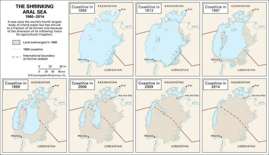
Figure 1.6.3: Historical and current satellite comparison of the Aral Sea, 1960 and 2014 — showing dramatic shrinkage. Photo Courtesy: Britannica Editors (2026).
Analysis Exercise for Students
Participants are instructed to analyze large canal irrigation systems and their basin-scale impacts, focusing on how river diversion decisions accumulate downstream ecological and social costs. Discussion to be initiated in Forum W-001, tag: Case Study 1.
Case Study 2: Irrigation Expansion and Malaria Risk
Reading Exercise
Before reading this case, download and review Kibret et al. (2014) and Boelee et al. (2013) from the reference list. Kibret et al. provide the empirical basis for the Ethiopia irrigation-malaria link; Boelee et al. provide the broader health-irrigation framework in African contexts.
Instructions for Students
Read the case below and reflect on how the institutional separation of agriculture and health governance produces predictable health externalities. Post in Forum W-001 under the tag "Case Study 1.6-B".
Case Study 1.6-B: Irrigation Expansion and Disease Ecology — Ethiopia
The Awash Valley in Ethiopia's Rift Valley is one of the country's most intensively irrigated regions. Large commercial irrigation schemes drawing from the Awash River and its tributaries produce cotton, sugar, fruits, and vegetables for domestic markets and export, while smaller smallholder irrigation schemes support vegetable production and food security across a large rural population. It is also, in irrigated areas, a region of elevated malaria burden.
The connection is not coincidental. The expansion of irrigation infrastructure — canals, distribution channels, poorly drained paddy fields, reservoir margins — has created an extensive mosaic of slow-moving, warm, shallow water across a landscape where natural water was previously seasonal and limited. Anopheles arabiensis, the dominant malaria vector in the region, breeds precisely in these conditions. Canal-irrigated areas provide year-round breeding habitat, extending the malaria transmission season beyond its natural limits and dramatically increasing vector density.
The epidemiological evidence is stark. Kibret et al. (2014) compared malaria incidence in villages within irrigation schemes and in nearby villages without irrigation, controlling for other relevant variables. They found malaria incidence rates up to six times higher in irrigated villages, with the difference most pronounced during the dry season — the period when standing water in canals provides breeding habitat that would not otherwise exist, and when the contrast with the naturally dry landscape is greatest. A child in an irrigated village in the Awash Valley faces a malaria risk substantially higher than a child in an equivalent non-irrigated village a few kilometres away. The burden falls unevenly within affected households. Women who perform more agricultural labour at the field edge and canal margin face higher exposure to mosquito bites. Children under five face the highest mortality risk from malaria infection. Households experiencing malaria face direct costs — medical treatment, drugs, transport to health facilities — and indirect costs — reduced agricultural labour productivity, inability to attend school, caregiver time diverted from other activities — that can constitute a significant share of annual income in subsistence farming households. A community health worker in Melka Werer recalled: "We have more food now from the irrigation. But we also have more malaria. People get sick during planting and harvest. They cannot work. The crops sometimes go to waste." Food security gained; health security eroded. The exchange was never formally negotiated.
The institutional roots of this problem are clear. Irrigation projects in Ethiopia — as in most countries — are designed, approved, and implemented by agricultural development agencies operating under mandates to increase food production and rural incomes. Environmental Impact Assessments are conducted, but health impact assessment — systematic evaluation of the disease ecology consequences of the proposed infrastructure — is not standard practice. Health ministries are not routinely consulted during irrigation project design. The result is that malaria costs generated by irrigation investment are not included in project cost-benefit analysis; they are externalised onto the health system and affected households.
Technical solutions to reduce irrigation-associated malaria exist — and several can be implemented with limited additional cost if incorporated at the design stage rather than retrofitted after construction. Canal lining reduces seepage that creates peripheral waterlogging. Intermittent irrigation (alternating wet and dry periods in fields) can reduce the standing water available for mosquito breeding in rice paddies. Improved drainage design reduces the ponding in which Anopheles breeds. Vegetation management around canal margins removes resting habitat. Where these measures are adopted, vector density and malaria incidence can be substantially reduced — but only if someone is responsible for them, which requires coordination between agriculture and health authorities that is currently absent in most project management frameworks.
Think: Should health risk assessment be mandatory in irrigation planning? How can agricultural and health governance be institutionally integrated? Who bears responsibility for health costs generated by development projects?
Livestream Zoom Session with Dr./Mr./Ms.
Topic: Irrigation Between Production and Sustainability — Field Perspectives from [Region]
Date: [Date]
Time: [Time] Central European Time (CET)
Zoom Link: [Link]
Prerequisite: Read the session note PDF. The session will address practical irrigation governance challenges and successful reform approaches from the practitioner's field experience.
1.6.4 Irrigation Technologies and Water Optimization
Modern irrigation technologies are designed to increase water use efficiency (WUE) — the amount of crop yield produced per unit of water applied. The range from traditional flood irrigation to precision drip systems represents a significant spectrum of efficiency, cost, management complexity, and social accessibility.
Surface (flood) irrigation — directing water across fields from field borders, basins, or furrows — is the oldest and most widespread irrigation method, accounting for approximately 85% of global irrigated area. It is low-cost to establish and maintain, requires minimal technical management capacity, and is accessible to smallholder farmers with limited capital. However, uniformity of water application is poor; on uneven terrain, some areas receive excess water while others are under-irrigated. Runoff and deep percolation losses can be high where application rates exceed soil infiltration capacity.
Surface (flood) irrigation — directing water across fields from field borders, basins, or furrows — is the oldest and most widespread irrigation method, accounting for approximately 85% of global irrigated area. It is low-cost to establish and maintain, requires minimal technical management capacity, and is accessible to smallholder farmers with limited capital. However, uniformity of water application is poor; on uneven terrain, some areas receive excess water while others are under-irrigated. Runoff and deep percolation losses can be high where application rates exceed soil infiltration capacity.
Drip (micro) irrigation delivers water directly to the root zone of individual plants through low-pressure emitters on or below the soil surface. It produces the highest application efficiency of any irrigation method — effectively eliminating runoff, minimizing evaporation and allowing precise control of water and nutrient delivery. Where properly designed and maintained, drip systems can reduce water application by 30–50% compared with surface methods for equivalent yields (Gleick, 2021).
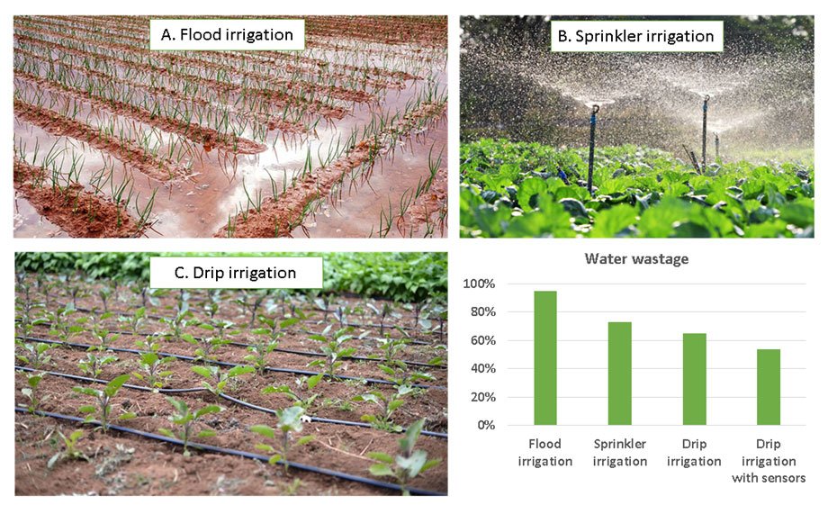
Figure 1.6.4: Comparison of irrigation methods (a) flood/furrow irrigation with runoff and deep percolation losses; (b) sprinkler irrigation with evaporation losses; (c) drip irrigation with minimal losses and precise root-zone delivery. Efficiency percentages for each type have been shown (Rehman et al., 2023). Photos courtesy: Agri-route (2023), KSNM-DRIP (2025), ADRIVI (nd).
The Rebound Effect: Why Efficiency Does Not Always Mean Conservation
It is tempting to conclude that the wide adoption of drip and other high-efficiency irrigation technologies would substantially reduce total water use and relieve pressure on overexploited water resources. The evidence is more complicated.
The rebound effect (also called the Jevons paradox in energy economics) refers to the tendency for efficiency gains to be partly or wholly offset by increased use of the more efficient technology. In irrigation, the rebound effect operates through several pathways. Where water is allocated by volume and efficiency improvements reduce the volume used per unit of land, the saved water is often reallocated to irrigate additional land rather than returned to the river or aquifer. Where water rights are insecure and not tied to specific volumes, efficiency improvements create no incentive to use less — farmers simply irrigate more intensively. Where water is unpriced or underpriced, the economic gains from efficiency improvements are captured as profit rather than as reduced withdrawal.
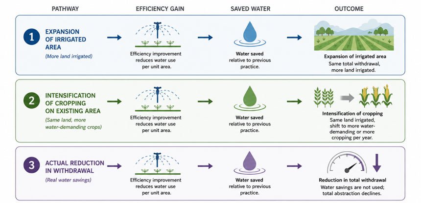
Figure 1.6.5: The irrigation rebound effect showing three pathways with efficiency gains, saved water, and expansion of irrigated area. Source: Diagram by Kartik Omanakuttan.
Israel is frequently cited as a success story of irrigation efficiency and genuinely has achieved remarkable crop production under severe water constraints through drip technology, wastewater reuse, and precision scheduling. But the Israeli case also illustrates the political dimensions of water governance: Israel's water system, including the National Water Carrier completed in 1964, operates in a context of contested water rights between Israeli users and Palestinian communities in the West Bank and Gaza, where Palestinian access to irrigation water and aquifer rights remains highly constrained by the political-legal framework of occupation. Efficient technology alone cannot resolve the governance dimensions of water allocation.
Precision Irrigation and Emerging Approaches
Precision irrigation integrates soil moisture sensors, weather forecasting, crop water demand models, and remotely sensed vegetation indices to schedule irrigation at the exact time and in the exact quantity that crops require, eliminating application beyond agronomic necessity. Combined with variable-rate irrigation systems capable of applying different amounts to different zones of a field, precision approaches can reduce water application by 20–30% beyond fixed-schedule drip systems (Hedley and Yule, 2009).
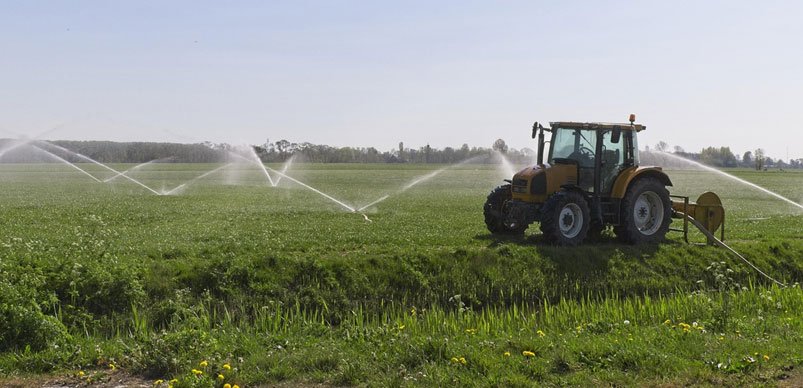
Figure 1.6.6: Precision water delivery systems that optimize crop hydration while reducing waste. Source: Pixabay
Deficit irrigation — deliberately applying less water than maximal crop demand, accepting some yield reduction in exchange for large water savings — is another efficiency strategy with significant conservation potential. Research has shown that many crops can tolerate moderate water stress at specific growth stages with limited yield penalty; applying water only during stress-sensitive periods allows substantial reductions in total seasonal application.
Treated wastewater reuse for irrigation — well-established in Israel, parts of the USA, the Gulf states, and increasingly adopted across the developing world — represents a qualitatively different approach to the water-food nexus, one that decouples irrigation from freshwater sources and can reduce pressure on rivers and aquifers while capturing the nutrient value of treated effluent for crop production.
1.6.5 Legal, Economic and Institutional Frameworks for Irrigation Governance
Read the Bare Fact
Irrigation outcomes are shaped less by the technology farmers use than by the incentive structures governments create. Where water is free or underpriced, farmers have no financial incentive to conserve it. Where energy for pumping is subsidised, groundwater extraction costs are insulated from physical reality. Where crop price supports favour water-intensive commodities, farmers are paid to grow crops that would not be viable under honest water pricing. And where water rights are attached to land and measured in area rather than volume, there is no mechanism to reward users who apply water efficiently rather than abundantly.
The dominant instruments of irrigation governance — water allocation laws, agricultural subsidy frameworks, energy pricing policies, infrastructure investment programmes — were designed in the mid-twentieth century to maximise production in a world where water was abundant, and food was scarce. Many remain largely unchanged, while the water availability and ecological conditions they were designed for no longer exist.
Key Legal Instruments
Irrigation Acts and Water Allocation Policies provide the legal framework for determining who can divert water from rivers and extract from aquifers for irrigation, and in what quantities and under what conditions. The range of doctrines across jurisdictions is significant:
- Prior appropriation (dominant in the western United States): "first in time, first in right" — older water rights take priority over newer ones. In conditions of scarcity, junior rights are curtailed first. This creates predictability but tends to concentrate water rights in historically powerful interests and locks in allocation patterns established in a very different era.
- Riparian rights (England, eastern USA, many common law systems): landowners adjacent to a watercourse have the right to use a reasonable share of the water. This doctrine is poorly adapted to large-scale irrigation requiring diversions far from the watercourse.
- State ownership (France, Spain, much of the developing world): the state owns all water and grants licences for use. In principle, this allows the state to manage water in the public interest; in practice, licence systems are often captured by commercial agricultural interests and lack the monitoring and enforcement capacity to be effective.
Agricultural Subsidy Frameworks (including input subsidies (fertilisers, seeds), price supports for irrigated crops, and infrastructure investment in canal and drainage systems) are arguably more powerful determinants of irrigation demand than water allocation law. Where governments guarantee minimum prices for water-intensive crops like sugarcane, rice, or cotton, farmers have strong incentives to maximise irrigated area, regardless of water availability or ecological cost. The history of irrigation over-development in South Asia, the Nile basin, Central Asia, and elsewhere is, in significant part, a history of agricultural price and subsidy policies that made water-intensive production more profitable than ecological sustainability.
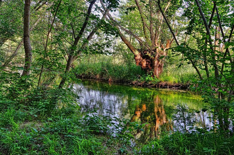
Figure 1.6.7: Farmers practice agriculture along the banks of rivers, lakes, and streams which is referred to as a Riparian agriculture system. Source: Pixabay
Energy Pricing Policies and their relationship to groundwater extraction have been addressed in Unit 1.5. In the context of surface water irrigation, energy pricing matters primarily for pumped lift systems and pressurised distribution networks. Where electricity prices recover the full cost of supply, pressurized irrigation technologies are more likely to be adopted only where their agronomic benefits justify the energy cost; where electricity is subsidized, any technology becomes financially viable regardless of efficiency.
Water User Associations (WUAs) — organizations of irrigation water users that take on collective responsibility for operation and maintenance of irrigation infrastructure, water allocation among members, and fee collection — represent the institutional bridge between state-managed water supply and farm-level use. Well-functioning WUAs can achieve more efficient water distribution, better maintenance of tertiary canals, and more equitable allocation than top-down bureaucratic management. They also carry risks: WUAs can be captured by larger, wealthier irrigators; they may exclude women, who perform much of the irrigation labour but rarely hold formal water rights; and they can be de facto privatization vehicles for water governance functions that states should retain.
Environmental Flow Requirements in the context of irrigation governance assert the principle that rivers and their dependent ecosystems have a right to a minimum quantity and quality of water, that not all water in a catchment is available for consumptive use. Environmental flows represent the institutionalization of ecological values in water allocation law. Their adoption — in Australia's Murray-Darling Basin, South Africa's National Water Act, and elements of the EU Water Framework Directive — is significant but contested. Agricultural water users consistently resist environmental flow allocations as reductions in their productive water supply; yet without them, the ecological consequences documented throughout this module — dead zones, collapsed fisheries, dried rivers, lost biodiversity — are the inevitable outcome of allocation systems that recognise no claim on water other than human use.
Task for Participants
Post in Forum W-001 under the tag "Policy Analysis Task 1.6". For the irrigation governance framework of your country or region, identify and briefly describe one of the following:
- The legal doctrine governing who has the right to divert water for irrigation and in what quantities.
- Whether agricultural subsidies or energy pricing policies encourage water-intensive cropping or over-irrigation
- Whether environmental flow requirements exist and, if so, whether they are enforced in practice
Mandatory Quiz: [Click Here]
1.6.6 Irrigation Infrastructure and Hydrological Fragmentation
How Irrigation Fragments Hydrological Systems
Large-scale canal irrigation is, at its core, a deliberate act of hydrological fragmentation and conversion — the transformation of a naturally dynamic river system, with its seasonal rhythms and connectivity, into a managed water delivery network optimised for stable, predictable supply to agricultural fields.
Canal networks impose rigid hydraulic geometries — fixed channels, division structures, control gates — on landscapes where water previously flowed across floodplains, recharged wetlands, and sustained riparian ecosystems according to the variability of climate and hydrology. The lateral connectivity between rivers and their floodplains — described in Unit 1.4 as essential to the ecological functioning of river systems — is typically severed by the embankments that contain canals and protect irrigated fields from natural flooding. The seasonal flood pulse, which in unregulated systems deposits nutrients, recharges floodplain wetlands, and cues fish reproduction, is replaced by the controlled release regime of the irrigation system.
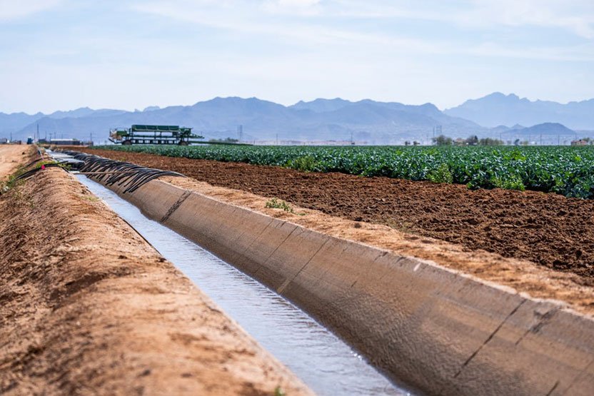
Figure 1.6.8: An irrigation canal running through a farm. Source: Pexels
The sediment dynamics of river systems are equally disrupted. Canal head structures divert clear water — stripping the sediment-carrying capacity that would otherwise replenish delta soils and coastal areas. The combination of reduced flow and reduced sediment supply in rivers downstream of major irrigation diversion points is a primary driver of delta erosion and subsidence across South Asia, the Nile Delta, the Colorado River Delta, and the Mekong Delta, as discussed in Unit 1.4.
Technological Lock-In
Once large-scale irrigation infrastructure is built, it creates technological lock-in — a condition in which the capital investment, political commitments, institutional arrangements, and economic dependencies created around the infrastructure make meaningful reform extremely difficult even when its costs are clearly understood.
Lock-in operates through several mechanisms. Physically, irrigation infrastructure — dams, headworks, main canals, distribution systems — represents sunk costs of enormous scale; abandonment or radical redesign is not economically straightforward. Economically, entire regional agricultural systems — crop choices, farming practices, land values, rural employment — are built around the assumption of irrigation water availability; removing that water would cause immediate and concentrated economic disruption. Politically, the constituencies that benefit from irrigation — commercial farmers, rural politicians, agricultural equipment suppliers, canal authorities and their staff — are well-organised, well-resourced and highly effective at defending existing arrangements against reform. The communities most damaged by irrigation — downstream riparian communities, subsistence fishers, delta farmers — are typically less organised and less politically powerful.
This lock-in dynamic transforms irrigation from an adaptive technology — a tool that could be deployed differently as circumstances change — into a structural vulnerability. As groundwater tables decline beneath irrigated regions, as river flows diminish, as climate variability increases, and as salinisation progresses, the irrigation systems most adapted to past conditions become least well-suited to future ones. But the political and economic barriers to adaptation are precisely those created by the previous generation of infrastructure investment.
Managed transition — designing pathways away from unsustainable irrigation toward more water-limited agriculture, with explicit support for affected communities — is the governance challenge that lock-in creates. It requires acknowledging that some irrigation cannot continue indefinitely, planning for the adjustment of agricultural systems and rural economies, compensating those most damaged by transition, and building the political coalitions that can sustain reform against the resistance of incumbent interests. This is some of the hardest governance work in water management, and it is increasingly necessary.
Discussion Task for Students
Identify an irrigation infrastructure project or scheme, existing or proposed, in your country or region. In Forum W-001 under the tag "Fragmentation and Lock-In Discussion", assess:
- What hydrological connectivity (longitudinal, lateral, vertical) has it disrupted or would it disrupt?
- What communities bear the ecological and social costs of that disruption?
- What technological lock-in has it created or would it create — what economic and political dependencies now make reform difficult?
- Whether alternative designs or governance arrangements could have achieved similar agricultural objectives with less hydrological disruption and more equitable cost distribution
Wrap Up Unit 1.6: Synthesis and Reflection
Post your synthesis in Forum W-001 under the tag "Wrap Up Unit 1.6", addressing:
- One insight about irrigation — technical, ecological or governance-related — that changes how you understand a water resource challenge in your professional context.
- One example where irrigation has demonstrably improved food security or rural livelihoods in your region — and what ecological or social costs accompanied that benefit.
- Whether irrigation governance in your country is oriented toward the long-term sustainability of the water and soil resources on which irrigation depends, or toward maximising short-term production. What interests sustain whichever orientation predominates?
Closing Note
Irrigation has shaped civilisations, fed billions, and transformed landscapes on every continent. It will continue to be essential to food security in a world where water is becoming scarcer, more variable, and more contested. But the irrigation systems that humanity has built were designed for a water world that no longer exists — one of apparent abundance, low energy costs, and minimal concern for ecological or social externalities. Managing the transition from that world to one in which water scarcity is real, ecological limits are binding, and social equity matters requires institutional imagination that is different in kind from engineering skill. The dams and canals are the easy part. The governance of water — who gets it, at what cost to whom, for how long, and within what ecological limits — is where the real difficulty, and the real stakes, lie.
References
ADRIVI (nd). Blog-Modern management of centennial furrow irrigation. Available online at:
https://www.agrivi.com/blog/modern-management-of-centennial-furrow-irrigation/
Agri-route (2023). Blog-What is drip irrigation and why is it beneficial? Available online at:
https://agri-route.com/blogs/news/what-is-drip-irrigation-and-why-is-it-beneficial
Ataniyazova, O. A. (2003, March). Health and ecological consequences of the Aral Sea crisis.
In 3rd World Water Forum, Regional Cooperation in Shared Water Resources in Central Asia, Kyoto (Vol. 18). http://caee.webhost.utexas.edu/prof/mckinney/ce385d/papers/atanizaova_wwf3.pdf
Boelee, E., Yohannes, M., Poda, J. N., McCartney, M., Cecchi, P., Kibret, S., ... & Laamrani, H.
(2013). Options for water storage and rainwater harvesting to improve health and resilience against climate change in Africa. Regional Environmental Change, 13(3), 509-519. https://www.researchgate.net/profile/Fitsum-Hagos-4/publication/257480629_Options_for_water_storage_and_rainwater_harvesting_to_improve_health_and_resilience_against_climate_change_in_Africa/links/53db294b0cf2631430cb1b44/Options-for-water-storage-and-rainwater-harvesting-to-improve-health-and-resilience-against-climate-change-in-Africa.pdf
Britannica Editors (2026). Aral Sea. Encyclopedia Britannica.
https://www.britannica.com/place/Aral-Sea
FAO AQUASTAT (2022). AQUASTAT - FAO's Global Information System on Water and
Agriculture. https://www.fao.org/aquastat/en/
Gleick, P. H., & Cooley, H. (2021). Freshwater scarcity. Annual Review of Environment and
Resources, 46(1), 319-348. https://doi.org/10.1146/annurev-environ-012220-101319
Hedley, C. B., & Yule, I. J. (2009). A method for spatial prediction of daily soil water status for
precise irrigation scheduling. Agricultural Water Management, 96(12), 1737-1745. https://doi.org/10.1016/j.agwat.2009.07.009
Kahamba, N. F., Tarimo, F. S., Kifungo, K., Mponzi, W., Kinunda, S. A., Simfukwe, A., ... & Finda,
M. F. (2024). Societal uses of the main water bodies inhabited by malaria vectors and implications for larval source management. Malaria Journal, 23(1), 336. https://doi.org/10.1186/s12936-024-05154-z
Kibret, S., Wilson, G. G., Tekie, H., & Petros, B. (2014). Increased malaria transmission around
irrigation schemes in Ethiopia and the potential of canal water management for malaria vector control. Malaria journal, 13(1), 360. https://doi.org/10.1186/1475-2875-13-360
KSNM-DRIP (2025). Sprinkler irrigation advantages and disadvantages. Available online at:
https://ksnmdrip.com/blogs/sprinkler-irrigation-advantages-and-disadvantages
Micklin, P. (2007). The Aral sea disaster. Annu. Rev. Earth Planet. Sci., 35(1), 47-72.
https://doi.org/10.1146/annurev.earth.35.031306.140120
Peveling, R., Köhler, V., KRASS Service, Lamers, J., Latchininsky, A., Lux, T., Navratil, P.,
Ströbel, H., Wilps, H., & Ziegler, D. (2010, April). The Aral Sea disaster — From living in crisis to solving problems. Retrieved from: https://www.researchgate.net/publication/375030042_The_Aral_Sea_Disaster_-_From_Living_in_Crisis_to_Solving_Problems
Rehman, D., Jamil, M. A., Badar, H. M. S., Awan, M. D. A., Chaudhry, M. U., & Kajla, N. I.
(2023). Enhancing crop production and water conservation through IoT-based smart irrigation systems. Journal of Computing & Biomedical Informatics, 5(01), 96-104. https://www.jcbi.org/index.php/Main/article/view/175
Shrivastava, P., & Kumar, R. (2015). Soil salinity: A serious environmental issue and plant growth
promoting bacteria as one of the tools for its alleviation. Saudi journal of biological sciences, 22(2), 123-131. https://doi.org/10.1016/j.sjbs.2014.12.001